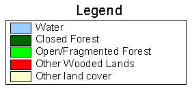
Forest Resource
Overview
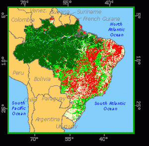
Brazil has the world´s largest area of tropical rainforests. Forests cover around 2/3 of Brazil´s land area. The country´s forest classes can largely be divided into Amazon, Atlantic and araucaria forests. The humid tropical Amazon rainforests in the northwestern half of the country account for 95 percent of Brazil´s forest area. The Amazon forests comprise large areas of broad-leaved forests including those growing in a variety of dryland and alluvial zones, and lowland and submontane forests. To the south of the Amazon are extensive areas of cerrado (savanna-type) woodlands. The Atlantic forests comprise a discontinuous band of humid evergreen forests along Brazil´s Atlantic coastline between Natal and Porto Alegre. In the south (especially in Parana, Santa Caterina and Rio Grande do Sul) there is a transition zone of coniferous Araucaria spp. (and Podocarpus spp.) forests. Extensive areas of the Atlantic and araucaria forests have been cleared for agriculture. Brazil has around 5 million hectares of forest plantations, based on pine and eucalyptus species. Brazil has more than 30 million ha of protected areas including many state parks and reserves.
Forest Types
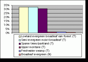
+124,982 ac Mangrove (T)
+545,376 ac Deciduous/Semi-Deciduous Broadleaf(T)
+1,499,537 ac Needleleaf (T)
+5,077,826 ac Sparse Trees/Parkland (N)
Geographic Description
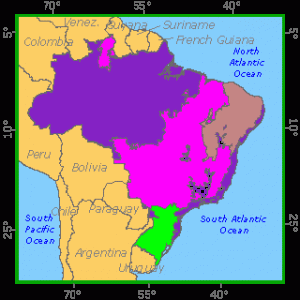
The Federative Republic of Brazil has continental dimensions. It extends over 8 547 400 km2, 40 degrees of longitude, from the extreme east of the state of Paraiba on the Atlantic, to the extreme west of the state of Acre on the border with Peru, and 39 ° of latitude, from the northern tip of the territory of Roraima bordering Guyana and Venezuela, 5°15’N, to the southern tip of the state of Rio Grande do Sul on the Atlantic coast and bordering Uruguay.
The topography is, in most parts, gentle and 93 percent of the country is below 800 meters. The highest peaks -above 2 500 meters- are confined to two regions, the northern border with Venezuela in the territory of Roraima and the state of Amazonas and the states of Espirito Santo, Minas Gerais, Rio de Janeiro and São Paulo, in the south-east Atlantic coast.
Two geographic features dominate the landscape of Brazil: the vast Amazon Basin, which spans the width of northern Brazil, and an extensive highland plateau, known as the Brazilian Highlands, which covers most of the south and south-east. The Amazon Basin contains the world’s largest river and the world’s largest tropical rain forest. In the south and south-east, the Brazilian Highlands an eroded plateau dotted with irregular mountains and crossed by river valleys forms the major feature of the landscape. The highlands separate Brazil’s inland regions from a narrow coastal plain that stretches from Ceará in the north-east to the Uruguayan border in the south.
The Amazon River and its tributaries is the largest in the world based on its flow, and the second longest in the world after the Nile. The Paraná River drains much of the southern part of the country and empties into the Río de la Plata estuary in Argentina. The principal river of the eastern plateau region is the São Francisco. Many smaller rivers drain the land sloping to the Atlantic seaboard.
The climate of Brazil is largely tropical or subtropical, with temperatures averaging from 26° C with little seasonal variation in the lower Amazon basin to 16° C in the southern region (less on the mountains of the south-eastern Atlantic coast). Annual rainfall varies from 3 000 mm or more in some parts of the northern region (the Colombian border and the delta of the Amazon river) to 1 600 mm in central Brazil to as little as 300 mm in some parts of the “drought polygon” in the north-eastern region (in particular the states of Rio Grande do Norte, Paraiba, Pernambuco, Alagoas and Sergipe).
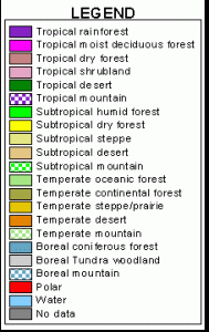
Ecological Zones
Forest Industry
Resources Forest cover Vegetation
Natural Woody Vegetation Description
Introduction
The diversity of Brazilian vegetation reflects the large dimensions of the country and the wide range of climatic and ecological conditions.
Closed Forests
Broadleaved
The humid tropical forests of the Amazon region constitute the largest block of closed forests in any tropical country. They correspond to humid or very humid climates (rainfall more than 1 500 mm) at lowland to submontane altitudes (less than about 2 000 meters) and can be “ombrophilous” or “evergreen”, “seasonal” or not. The number of forest types is large, whatever the criteria used, whether dryland or alluvial zones (swamp forests and periodically or permanently inundated forests). Hueck (“Los Bosques de Sudamerica”), for instance, mentions eight main “regions” of dryland forest (Amazon delta, Peru and Jari, Tocantins and Gurupi, Xingu and Tapajoz, Madeira and Purus, western “Hylaea”, north-western “Hylaea” (Rio Negro) and the region of Acre, Beni, Mamore and Guaporé). In the alluvial forests it is common to speak about “varzea forests” and “igapo forests”, some of these forests being mainly constituted of palms (“miritizal” of Mauritia flexuosa, “jauarizal” of Astrocaryum jauary etc.).
Special mention must be made of the “campinaranas”, “amazonian caatingas”, “caatingas of the Upper Rio Negro”, “humirizal”, and “carrasco”, which are less dense and tall than the usual forests on dry land, and which Aubreville proposes to call under the generic term of “thickets and low forests on white sands”.
A differentiation is often made (e.g. (Reis, 1978)) between the “ombrophilous dense forest” (“densa”) and the “ombrophilous open forest” (“aberta”), which does not correspond to the division between open (woodlands) and closed (forests) as used in many vegetation classifications. The “ombrophilous open forests”, with or without palm trees (“cocal” or “cipoal”), or “liana forests” are composed of trees more distant than in the case of typical closed forests with a dense scrub story and correspond mainly to adverse edaphic conditions or limiting climatic conditions (transition between the amazonian forests and the cerrado and caatinga areas).
Considerable areas of humid forest with the palm tree known as “babaçu” (Orbignya speciosa) exist in the state of Maranhão, east of Belem. They probably correspond to a secondary type of the original humid forests after clearing of most tree vegetation except the babaçu trees, which are traditionally used for their oil seeds (Aubreville, 1961). Some specialists (Sampaio, Hueck) have made a special class in their phytogeographical classification for this type of stand.
Dry semi-deciduous forests can be found in the middle of the amazonian humid forests (called “floresta estacional semidecidual” by RADAMBRASIL). Dry semi-deciduous (and deciduous) forests exist also, generally in degraded form, in the transition zone between the humid forests with babaçu and the caatinga region of the north-east.
The humid evergreen forests of the Atlantic coast, the climax zone of which stretches from Natal (6° S) to parallel 30° S on a 100- to 200-km wide band, remains only on the ridges and their total area does not exceed 3 million hectares. In the south there is a transition zone with coniferous stands of Araucaria spp. and Podocarpus spp.
Semi-deciduous and deciduous forests are found in patches within the cerrado area and on its southern fringe down to the Paraguayan border, often in contact or mixture with the dense wooded savannas (cerradãos”).
In the northeastern zone, a small proportion of the caatinga appears as dense forest (classified on the UNESCO/C.I.T.V. map as “sclerophyllous dominated extremely xeromorphic forest”) among many other open tree or scrub vegetation types.
Mangroves extend along the Atlantic coast from the border with French Guyana to Florianapolis in the southern state of Santa Catarina (28° S) where scrub trees of Laguncularia racemosa (“mangue-branco”) can still be found. The two other main species are Rhizophora mangle (“manue vermelho”) and Avicennia nitida (“manguesiriúba”). Within the area mapped by RADAMBRASIL (the coasts of state of Amapa, Para, Maranhão and Piaui), almost 1.3 million ha of mangrove forest were identified, while the UNESCO/C.I.T.V. map indicated for the whole of Brazil an area approximately equal to 3.6 million ha. Comparison with other maps, however, show that mangrove stands do not exceed a total area of 2.5 million ha (forests and scrubs).
Coniferous
The extent of the Araucaria angustifolia stands (“pinheiro do Parana”) was originally some 16 to 17 million ha; approximately half in the state of Parana, 20 to 25% in each of the states of Santa Catarina and Rio Grande do Sul and the rest in scattered patches in the states of São Paulo and Minas Gerais. Heavy exploitation and clearing for agriculture have considerably reduced these areas over the last fifty years. These forests, which are found above 500 m on the plateaus sloping from the littoral mountains to the Rio Parana, often have three stories (Aubreville, 1961): a dominant pure stand of Araucaria 20 to 25 m high, a dominated story of Podocarpus species or “Pinheiro bravo” (P. sellovii, P. lambertii) and some hardwood species (such as Phoebe porosa, Ilex paraguayensis or ervamate), and a thick undergrowth. Pure stands of Podocarpus spp. are found in the bottoms of the valleys.
Forest Map
Open forests
Broadleaved
(a) The “cerrado” region extends to more than 170 million ha (28) on the south amazonian forests form the territory of Rondonia in the west to that of Piaui in the east where it comes in contact with the caatinga region and down to the northern part of the state of São Paulo. Although some are fairly dense, they are classified here as “open hardwood forests” as they have always a grass layer that makes them sensitive to degradation by fires. They can therefore be compared to the African savannas. The following types are generally differentiated, although there exist a “continuum” of facies:
- “Cerradão” or “dense wooded savanna”, a fairly dense multi-storeyed vegetation type with dominant trees up to 20 meters and relatively long straight boles that corresponds to the transition between closed forests and the cerrado sensu stricto;
- The “cerrado” sensu stricto or “wooded savanna” with less high and more flexuous trees than those of the cerradão;
- The “campo cerrado” or “tree savanna” with scattered trees and shrubs;
- The “cerradinho” and “campo sujo” or “scrub savanna” with only scattered shrubs.
In most parts of the cerrado area, the stands are principally used for fuelwood. In the states of Minas Gerais and São Paulo they have been exploited for decades for the supply of charcoal to the iron industry. Around 10 million m3 of charcoal are made every year from the cerrado stands, approximately corresponding to an area of 200 000 ha. If one considers that fires and grazing are also taking place in many parts of the cerrado area, one can realise the heavy pressure on these stands. They will avoid depletion and degradation only if conservatively managed.
Other types of open woodlands exist in various parts of the country. The most important are:
- The wooded savannas within the amazonian forests, probably of anthropogenic origin (like those of the territory of Amapa), classified as “medium tall grassland with tree synusia” in the UNESCO/C.I.T.V. map, and where species characteristic of the cerrado can be found;
- The wooded savannas of the “campians”, patches of white sands within the amazonian forest area;
- The “chaco” stands with the main genera Schinopsis and Aspidosperma that can be found along the Paraguayan border (approximately 1.5 million ha according to Hueck and the UNESCO/C.I.T.V. map); it is interesting to note that the chaco species are also present 2 500 km north in wooded savannas of the Alto Rio Rurumu in the territory of Roraima (“savanna-steppe” of the RADAMBRASIL classification);
- The wooded and tree savannas of the caatinga region in the north-eastern region;
- The woodlands of the “Pantanal Matogrossense”, a large area of some 12 million ha, a complex of periodically inundated areas with tree and scrub vegetation on the higher elevation, mostly of the cerradão type;
- The palm savannas of Copernicia cerifera (“carnauba”, “palma de cera”) in the areas with high water table of the caatinga region of Mauritia vinifera (“buriti”) in the cerrado region, etc.
Other wooded land
Shrubs
The phytogeographic region called Caatinga covers more than 80 million ha, principally in the states of Piaui, Ceará, Rio Grande do Norte, Paraiba, Pernambuco, Alagoas, Sergipe and Bahia. It constitutes an extremely complex mixture of woody vegetation types with varying degrees of alteration and degradation by man (agriculture, grazing, fuelwood collection, fires), and transition to the cerrado types to the west and the south and to the Atlantic forest to the east. All cover types of varying heights and densities exist from patches of the original dry forest (“sclerophyllous dominated extremely xeromorphic forest” according to UNESCO/C.I.T.V. classification) to poor scrubland with scattered shrubs and cactaceae, through thickets of varying heights. Area statistics cannot be more than rough estimates until at least mapping by RADAMBRASIL is completed. However, most of the vegetation corresponds to scrub and thicket types at various degradation stages.
Other scrub types exist in:
- The “restingas” or sandy soils of the littoral area from São Luiz in the state of Maranhão to the border with Uruguay;
- The “vazantes”, a generic name for ill-drained areas along rivers:
- Inside the Amazonian forest, in zones periodically inundated that may amount to large areas, or in some campos like those in the Upper Rio Branco (in the corresponding map sheet No. 8 of the RADAMBRASIL project, scrub vegetation of periodically inundated areas and of campos covers more than 2 million ha).
References
Aubreville, A. (1961). Etude écologique des principales formations végétales du Brésil, et contribution à la connaissance des forêts de l´Amazonie brésilienne. Centre Technique Forestier Tropical, Nogent-sur-Marne, France.
Azevedo, L. G. de (1966). Tipos eco-fisionômicos da vegetação da Região de Januario (MG). An. da Acad. Brasileira de Ciencias (38) 31 de Dezembro de 1966, Supplemento. Rio de Janeiro.
Escola de Florestas U.F.P./RIGESA (1967). Inventario florestal de reconhecimento das florestas deAraucaria das formacoes sedimentares do Paleozoico no Estados do Parana e Santa Catarina. Curitiba.
Fishwick, R. W. (1974). Forestry in Brazil. Commonwealth Forestry Review 54(1)
Heiseke, D. R. (1975) Forest ecological study of woodland savannas in central Minas Gerais, Brazil. Centro de Pesquisa Florestal da Região do Cerrado. Belo Horizonte.
Projeto RADAM (BRASIL) (1973-1978). Lavantamento de recursos naturais, volumes 1-16. Ministério das Minas e Energia, Departamento Nacional da Produção Mineral, Rio de Janeiro/Belem/Salvador.
Projeto RADAMBRASIL (1978). Projecto RadamBrasil-cLevantamento de recursos naturais. Silvicultura 2(11) São Paulo.
Reis, M. S. (1978). Uma definição técnico-politica para o aproveitamento racional dos recursos florestais da Amazonia Brasileira. Presented at the 3rd Brasilian Forestry Contress, Manaus, 4-7 Dec. 1978. IBDF/PRODEPEF document, Brasilia.
Rizzini, C. T. (1975). Contribução ao conhecimento da estrutura do cerrado. Brasil Florestal 6(22) Rio de Janeiro.
Van Dillewijn, F. J. (1966) Inventário do pinheiro no Paraná. CERENA/Universidade Federal do Paraná/DGTC/FAO/CODEPAR, Curitiba.
Veloso, H. P. (1966). Atlas florestal do Brasil. Ministério do Agricultura, Rio de Janeiro.
I really like whqt you guys are usually up too.
This sort of clever work and coverage! Keep up the superb works guys I’ve
incorporated you guys to my own blogroll.