Forest Resource
Overview
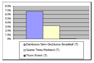
The Democratic Republic of the Sudan is moderately forested with around 17 percent forest cover and an additional 10 percent of other wooded land. Most of the northern half of Sudan is desert or semi-desert and vegetation is limited to scattered xerophytic shrubs such as Acacia ehrenbergiana. Closed forests are found in the mountain ranges and in the derived woodland savannahs. Closed tropical rainforest is confined to a few small, scattered localities, mainly at the foot of the Imatong mountains. Montane vegetation is predominantly in Equatoria province and is mainly coniferous, with Podocarpus milanjianus the dominant species. Open broadleaved forest is the most common forest type, with high rainfall woodland savannah extending into most parts of Equatoria and Bahr el Ghazal provinces. Low rainfall savannah extends through most of central Sudan. The country has significant areas of mainly Acacia senegal and A. nilotica plantations. Sudan has an extensive network of protected areas, mainly national parks and game reserves. Around 11 percent of Sudan’s forests are in protected areas
Geographic Description
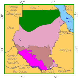
The Republic of the Sudan, located in north-eastern Africa, lies almost entirely within the tropics between latitude 21° 55´ and 3° 53´ N and longitudes 21° 54´ and 38° 31´ E. It is bounded on the north by Egypt; on the east by the Red Sea, Eritrea, and Ethiopia; on the south by Kenya, Uganda, and the Democratic Republic of the Congo (DRC, formerly Zaire); and on the west by the Central African Republic, Chad, and Libya. It is the largest country in Africa (2 505 813 km2). Of this, 29% is usually classified as desert, 19% as semi-desert, 27% as low rainfall savanna, 14% as high rainfall savanna, 10% as flood region (affected by floods and swamps) and less than 1% as true mountain vegetation.
Generally speaking the landscape is a basin-like plain with an elevation between 300 to 900 meters. There are a few groups of hills and a mountain range in the south, the Imatong Mountains, rising to over 1 500 m; Djebel Mara mountain (3 090 m) in Darfur province in the west and the Red Sea Hills (over 2 000 m) in the north-east near the coast. The highest point in Sudan, Kinyeti (3 187 m), is in the southeast.
The country can be divided into three natural regions. North of Khartoum is primarily desert. The central part of the country is mostly a grass-covered plain. The south contains a vast swamp, the Sudd, and rain forest.
Almost the entire drainage of the country is from south to north through the Blue and White Niles and the Sobat and Atbara Rivers. The Nile River is called the Bahr al Jabal in southern Sudan. North of the Sudd, the Bahr al Jabal is called the White Nile. It meets the Blue Nile, which flows from the mountains of Ethiopia, at Khartoum to form the main Nile River.
Sudan has a range of tropical continental climates with large daily and seasonal fluctuations in temperature. In the deserts, winter minimum temperatures as low as 5° C are common at night, while summer maximum temperatures often exceed 44° C. In the vicinity of Khartoum the average annual temperature is about 27° C. Temperatures, humidity and rainfall are all higher in the south.
There is a large variation in annual rainfall, from less than 75 mm in the desert, 75 mm to 300 mm in the semi-desert, 300 mm to 1 500 mm in the woodland savannas and to over 1 500 mm in the montane vegetation. Dust storms, called haboobs, occur frequently
Ecological Zones
Forest cover Vegetation
Introduction
The character of the vegetation in the Sudan depends largely on rainfall and soil type. The following classification is principally based on Harrison and Jackson (1958). There are no clear-cut boundaries between the various types. Since the vegetation of the desert, which lies almost entirely in the Northern province with some small areas in Darfur, Kordofan and Kassala provinces, is limited to some xerophytic shrubs (Acacia ehrenberiana, Capparis decidua and Fagonia cretica) along the water courses, this ecological type has been omitted from the description.
Closed Forests
Broadleaved
The closed forest types are found in the mountain ranges and in the derived woodland savannas. Their only common features are their closed canopy and multi-storeyed structure that differentiate them from the vegetation of the surrounding areas.
Tropical rain and gallery forests
Tropical rain forest is confined to a few small, scattered localities. Talanga, Lotti and Laboni forests are at the base of the Imatong Mountains; Azza forest is in Meridi district and there are other small areas on the Aloma Plateau and in the Yambio area. In these forests, four storeys can be distinguished in the vegetation:
- The canopy trees, which are 30 to 50 meters high with long, straight trunks, often buttressed at the base;
- The second-storey trees, from 15 to 30 meters high, usually not so straight, more copiously branched and with less tendency to form buttresses;
- The shrub layer, 4 to 6 meters high, often very dense, with numerous creepers and lianas; and
- The ground layer of herbs and grasses, usually sparse and often absent.
The species occurring in rain forest are similar to those of the drier parts of the forests of West Africa. The most common species are Chrysophyllum albidum and Celtis zenkeri, with Holoptelea grandis in Azza forest. A number of valuable timber trees are found, including Khaya grandifoliola, Chlorophora excelsa, Entrandrophragma angolense and others.
Gallery forest may be regarded as a reduced type of rain forest confined to the banks of streams. It is generally found in rather deep U-shaped valleys, and benefits both from the extra water supply of the streams and the protection against fire afforded by the steeply sloping banks. Other important species are Cola cordifolia, Syzygium guineense and, especially in swampy places, Mitragyna stipulosa.
Acacia nilotica forests
These forests occur along the Nile from the Egyptian frontier south as far as Jebelein on the White Nile and Roseires on the Blue Nile. They occur on land that is more or less flooded when the river rises. Acacia nilotica is the dominant species, and occurs over large areas as pure dense stands. In the shallower, less frequently flooded basins along the Atbara River and in some inland sites, they are replaced by Hyphaene thebaica palm forests.
Coniferous
Montane vegetation of the Imatong and Dongotona ranges.
Both ranges are located in Equatoria Province, the highest one culminating at 3 187 m. The lower slopes of these mountains, below about 1 500 meters, have vegetation in wetter areas similar to that of the derived woodland savanna, but with fewer species. In drier areas they are similar to low rainfall woodland savanna, especially on rocky hill slopes, with an abundance of Boswellia papyrifera and Terminalia brownii. Between 1 500 and 2 600 meters the climax vegetation is closed evergreen forest with Podocarpus milanjianus, Olea hochstetteri and Syzygium spp. dominant over a shrubby understorey. Second growth of Acacia xiphocarpa occupies large areas on old cultivation sites. Between 2 600 and 3 000 meters, Podocarpus milanjianus again forms the climax vegetation, but is less mixed with other species, apart from a little Olea hochstetteri. This zone includes large areas of mountain meadow dominated by the sedge Bulbostyles atrosanguineus. The bamboo Arundinaria alpina is also found. Much of the ground is wet or swampy because of the combination of high rainfall and low potential evapo-transpiration. Above 3 000 meters, ferns (Erica arborea and Myrica salicifolia) are dominant. Many species of herbs occur.
Montane vegetation of the Didinga range
This range lies also in Equatoria Province. The highest point, 2 963 m high, is Mount Lotuke at the south end, the summit carrying vegetation similar to that of the Imatong, with Podocarpus milanjianus mixed forest. Below this zone there is, however, a belt with a few relic trees of Juniperus procera, probably the remnants of a forest now destroyed by fire. The north end of the Didinga Mountains is a high plateau, in which trees of Podocarpus milanjianus occur in dense thickets of Olea chrysophylla, Soutia myrtina and other species. Dense forests of Podocarpus and Albizia maranguensis are confined to valleys.
Montane vegetation of the Red Sea hills
Up to 2 260 m high, these hills are situated in the north-eastern edge of the Sudan. The seaward facing slopes of the hills have a winter rainfall, while those not facing the sea have a very low summer rainfall. Mist and clouds have an important effect on the vegetation. A few localities enjoy both summer and winter rains. Near the Eritrean border, forests of Juniperus procera are found, with a few well-stocked areas but most ravaged by fire and overgrazing. Associated with Juniperus is Olea chrysophylla. Characteristic plants of the drier parts of this range include Dracaena ombet and Euphorbia abyssinica.
Open forests
Broadleaved
The woodland savanna region lies in the central and southern parts of the country, excluding the flood region in the south-east. The vegetation is of mixed grass types with bushes and trees, the proportions being dependent on rainfall, soil type, and fire frequency and intensity. Rainfall is confined to a few months followed by a long hot dry season.
High rainfall (> 900 to 1 000 mm) woodland savanna
The high rainfall woodland savanna extends into most parts of Bahr el Ghazal and Equatoria provinces. The trees are tall and broadleaved and thorny ones are rare. Coarse tall tussocks of perennial grasses predominate and hence fires are generally more fierce than in the low rainfall woodland savanna. Forest species easily recolonise areas with high rainfall when fire protection is provided. Two types have been described:
- Anogeissus-Khaya-Isoberlinia woodland is found on ironstone soils with rainfall of 900 to 1 300 mm. It is far from homogeneous due to variations in climate, different types of soil that occur from ridge top to valley bottom and the effect of different degrees of human disturbance.
The driest parts, with a rainfall of 900 to 1 000 mm, have such species as Sclerocarya birrea, Diospyros mespiliformis, Tamarindus indica, Balanites aegyptiaca with a good deal of Combretum ghasalense and many Acacia species. Mahogany (Khaya senegalensis) is sporadic on the ridges and near seasonal watercourses. With a slightly increased rainfall, these more drought-resisting species become rather rare. The ridge tops are denuded of soil in some places to form almost bare ironstone pans. But where the soil is deeper, they carry vegetation characterised by tangles of evergreen shrubs and lianas centred on termite mounds, with one or two larger trees on these mounds or in the centre of the tangle. The larger trees include Khaya senegalensis and Parkia oliveri. On the slopes down from the ridges, bu (Daniellia oliveri) is found, and, on clay soils, Anogeissus leiocarpus. In the valley bottoms, there tends to be open grassland or scattered trees of Terminalia laxiflora or T. macroptera. This belt of vegetation, of which mahogany and bu are the most valuable trees, extends from south of Aweil through Wau, Rumbek, Yirrol and Tali Post almost to Juba, and similar vegetation is found east of the Nile near Mongalla. To the south and west of this belt is a broad zone in which species of Isoberlinia are dominant over large areas, particularly on the lighter soils. At its northern drier limit, the Isoberlinia tends to be mixed with other species and is especially characteristic on the edge of the ironstone outcrops, where large blocks of ironstone have been broken off. Further south, Isoberlinia is found pure or almost pure over very wide areas, avoiding only the clay soils of depressions. It sometimes has an understorey of Monotes kerstingii or Uapaca sansibarica. These Isoberlinia woodlands are sensitive to human interference and where there has been much cultivation, they are replaced by more mixed vegetation of which Burkea africana and Terminalia mollis are typical species. At its wetter edge, Isoberlinia woodland is replaced by species of derived woodland such as Terminalia glaucescens and Albizia zygia. Many other large trees are found in smaller quantities and there are many species of small trees such as Combretum spp., Grewia mollis and Acacia seyal var. multijuga. Butyrospernum niloticum becomes dominant with the appearance of parkland, where other species have been removed during shifting cultivation and the latter preserved for the value of its fruit.
- Woodland derived from rain forest is found on ironstone and red loam soils in the south of the Equatoria provinces with over 1 300 mm of rainfall annually. There is a good deal of evidence that it has replaced rain forest destroyed by shifting cultivation and fires during the last few hundred years. Small areas of remaining rain forest and gallery forest have been described separately as belonging to “closed broadleaved forests”. Situated along the Zaire border from Li Yuby to the Aloma Plateau, it reappears again in the western foothills of the Imatong Mountains and in the Kinyeti valley. The Boma Plateau, although at a higher altitude, has generally similar vegetation. Characteristic species of larger trees in this woodland are Terminalia glaucescens, Albizia zygia, Vitex doniana and, though not in all areas, Acacia campylacantha. Anogeissus leiocarpus is common in places west of the Nile, growing up to 30 meters high. Smaller trees include Combretum binderianum, Grewia mollis, Annona chrysophylla, Bridelia scleroneuroides and Dombeya quinqueseta. The number of species per hectare is less than in the typical ironstone woodland, as can be expected in a vegetation type of comparatively recent origin. Especially in the wetter parts, occasional trees of Chlorophora excelsa, Khaya grandifoliola and Erythrophleum guineense are found.
Forest Industry
Low rainfall (<900 to 1 000 mm) woodland savanna
This type covers most of central Sudan and areas east of the flood region. In the drier parts, the trees are nearly all thorny and of low stature, with species of Acacia predominating. Broadleaved deciduous trees become predominant in the wetter parts, but there is not as great a variety of species as in the high rainfall woodland savanna, and thorn trees are usually present. There are also more annual grasses than perennials and a variable proportion of herbs. The following subdivisions have been distinguished.
- Terminalia-Sclerocarya-Anogeissus-Prosopis savanna woodland. Situated in southern Darfur and Kordofan Provinces with rainfall of over 600 mm, this type of vegetation is only distinguished from the “high rainfall woodland savanna” by the different soil type, the slightly poorer variety of trees and the mixture of annual grasses with the perennials. The trees attain 10 to 15 meters in height, and include Terminalia laxiflora, Sclerocarya birrea, Anogeissus leiocarpus and Prosopis africana. Tamarindus indica is usually associated with the dominants and in the drier parts small quantities of Guiera senegalensis, Acacia senegal and Dalbergia melanoxylon may be found.
- Anogeissus-Combretum hartmannianum savanna woodland. This type of vegetation, though occurring on dark cracking clays, is confined to well-drained sites, such as sloping ground with rock fragments frequently found near the surface, and over 800 mm of rainfall. Combretum hartmannianum and Anogeissus leiocarpus trees (10 to 15 m high) are nearly always mixed with a few specimens of Acacia seyal, alternating with evergreen trees such as Sterculia setigera.
- Acacia seyal-Balanites savanna. This savanna is found on cracking clays with over 600 mm of rainfall. But in the flood region, with over about 700 mm of rainfall, level sites cannot absorb all the water falling on them and the surface soil is waterlogged or flooded. Here the trees disappear and are replaced by open grassland. Patches of higher clay in the flood region do, however, carry typical savanna of this type and it appears again towards the fringes of the ironstone country. Acacia seyal is distributed throughout, usually more or less mixed with Balanites aegyptiaca. In the northern parts Acacia mellifera thickets occur as an understorey to the Acacia seyal. In the central parts, Acacia senegal is common, though it is rarely found in pure stands over extensive areas as it is in the sand country. Further south again Acacia fistula appears with Acacia drepanolobium on areas liable to flooding. In these peculiar areas Acacia campylacantha and Dichrostachys glomerata also form part of the local vegetation. On the southern fringe of the area Combretum hartmannianum and Entada sudanica begin to occur, mixed with Acacia seyal, the former being especially common when rock underlies the clay at a few meters below the surface.