Forest Resource
Overview
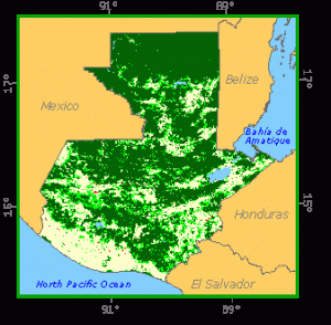
Guatemala is moderately forested with around 35 percent forest cover. Guatemala´s forests can be divided into 11 types, according to rainfall and elevation. The majority of forests are humid subtropical broad-leaved forests, located primarily in the lowland El Peten region in the north of the country. Guatemala has more than 300 broad-leaved tree species, with the main commercial species being Dialum spp. and Brosium spp.. Coniferous forests are particularly prevalent above 1200 metres and are the dominant forest type outside El Peten. Pines (especially Pinus oocarpa, P. psuedostrobus and P. tenuifolia) are the most common coniferous species. Montane coniferous forests are often mixed with quercus spp. and Cupressus lusitanica. Mangrove forests occur on both the Caribbean and Pacific coasts. National parks and recreational areas have been established throughout Guatemala. Around 20 percent of Guatemala´s land area is in legally protected areas.
Forest Types
+39,767 ac Mangrove (T)
Geographic Description
The Republic of Guatemala, located in Central America, is bounded on the west and north by Mexico; on the east by Belize and the Gulf of Honduras; on the south-east by Honduras and El Salvador and on the south by the Pacific Ocean. Its total area is 108 889 km2. The country can be divided into three main regions:
The great mountain chains stretching from the border with Mexico down to the border with Honduras, with the highest peaks being found in the west and deep valleys dividing the mountains. The southern edge of the western highlands is marked by the Sierra Madre range, which stretches from the Mexican border south and east, almost to Guatemala City. It then continues at lower elevations toward El Salvador, in an area known as the Oriente.
The chain is punctuated by steep volcanic cones, including Tajumulco Volcano (4220 m), the highest point in the country. The northern chain of mountains begins near the Mexican border with the Cuchumatanes range, then stretches east through the Chuacús and Chamá mountains and slopes down to the Santa Cruz and Minas mountains near the Caribbean Sea.
The northern and southern mountains are separated by a deep rift, where the Motagua River and its tributaries flow from the highlands into the Caribbean. Rainfall ranges from 1 200 to 5 000 mm.
The second region is a low-lying Pacific coastal area, a fertile plain of volcanic soil that stretches along the Pacific coast. Once covered with tropical vegetation and grasslands, this area is now developed into plantations where sugar, rubber trees, and cattle are raised. Rainfall varies between 1 000 and 2 000 mm.
The flat low-lying region of El Petén north of the mountains. This lowland region is composed of rolling limestone plateaux covered with dense tropical rain forest, swamps, and grasslands, dotted with ruins of ancient Maya cities and temples. Rainfall is between 2 000 and 4 000 mm.
Most of the population lives in the first region. The main conifer forests are also found here, but are subject to an ever-increasing demand for farmland and pasture. In the east of this zone, pressure has been so great that conifer stands are now only residual.
The second region – the low-lying Pacific coast – is primarily agricultural, although the effects of deforestation of the highlands situated to the north are felt here too, since it is a flood-prone zone.
Broadleaved tropical rainforests are found in El Petén, with small patches of P. caribaea in the south-east, in Poptún. A strong settlement policy has been pursued in this region in recent years, so that the forested area has shrunk considerably. Until very recently, only a small part of the El Petén region was accessible by road, river or tracks.
The climate of Guatemala varies according to altitude, from hot coastal plains to cold mountain heights. Temperatures vary greatly from area to area because of differences in altitude. The plains and lowlands have an average yearly temperature of about 27° C with little seasonal change.
Mountain valleys 1 200 to 1 800 meters high are usually comfortably mild. They have a yearly average temperature of 16° C to 21° C. The higher valleys sometimes have frost, and average 4° C. Rainfall varies as noted above. The rainy season generally lasts from May to November, and daily showers fall during most of this period.
Forest Industry
Resources Forest cover Vegetation
Natural Woody Vegetation Description
Introduction
Holdridge (1975) distinguishes several environmental life zones in Guatemala, the main ones being “subtropical wet forest”, “subtropical moist forest”, “subtropical low montane wet forest”, “subtropical low montane moist forest”, “subtropical montane wet forest”, “subtropical montane moist forest”, “subtropical dry forest”, “subtropical rain forest” and “subtropical low montane rain forest”.
Closed Forests
Broadleaved
On the basis of their complexity, Holdridge classifies the closed forests of El Petén as climax formations. Over 300 species of trees have so far been identified. However, when commercial or potentially commercial species of trees with a DBH of over 40 cm are considered, two genera (Dialium and Brosimum). Another eight commercial species including Calophyllum brasiliense, Vatairea lundellii, Ceiba sp., Manilkara zapota, Terminalia amazonia and Spondias mombin, Swietenia macrophylla, and Cedrela odorata, and various species of palm are found in many places.
Coniferous
Conifer stands tend to be found mainly at altitudes between 1 200 and 2 000 m. The dominant vegetation is Pinus sp and Quercus sp. forest, although these genera are found in association with such other species as Cupressus lusitanica and Liquidambar styraciflua. The undergrowth usually contains the Eugenia, Myrica, Hedyosmum and Piper genera.
About ten species of pine are found in the country, but the largest conifer forests are made up mainly of three species, Pinus oocarpa, P. pseudostrobus and P. tenuifolia, sometimes with Cupressus lusitanica. Small stands of Abies guatemalensis (fir tree) and Juniperus standeleyii are found at higher altitudes. Other conifers are P. ayacahuite, P. rudis and P. montezumae.
P. oocarpa forests cover the largest area, for reasons of soil and climate. The trees tend to be ill-formed and have poor growth, and fires often affect the forests. Although P. pseudostrobus and P. tenuifolia grow better and have better phenotypic features, the fact that they grow on better soil means that they have suffered more from the inroads of agriculture. P. hartwegii and P. rudis are found in higher places. Various species of Quercus sometimes form very open pure stands.
P. oocarpa stands vary considerably in height, ranging from ill-formed brushland of under 3 m to forests of over 20 m with acceptable trunks, scattered in small isolated stands. Inga, Persea, Carpinus and Ostrya sp. are also found (Lehmann, 1977).
The growth of mixed stands of Pinus and Quercus (as well as Liquidambar) depends more on edaphic conditions.
The four main conifer forests are found in Alto Cuchumatanes north of Huehuetenango, in María Tecún between Sololá and Totonicapán, in Sierra de las Minas between Zacapa and Izabal and in the Salamá area.
Pine forests are being destroyed by grazing and by clearing for agriculture. Good quality stands are now confined to the most inaccessible areas and the Department of Totonicapán.
References
FAO (1970). Estudio de preinversión sobre desarrollo forestal – general. Vol. I, FO/SF:81/GUA 6, Rome.
Holdridge, L. R. (1975). Taller sobre mapificación ecológica en el nivel de zona de vida. Proyecto GUA/72/006, Documento de Trabajo No. 9, Guatemala.
Lehmann, R, De Jongh, O., and Aguilar, J. M. (1977). Fundamentos para mejorar los bosques del área demostrativa. Proyecto GUA/72/006, Documento Interno No. 17, Guatemala.
Forest Map