Forest Resource
Overview
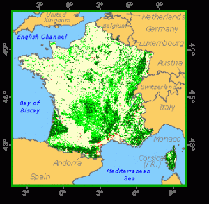
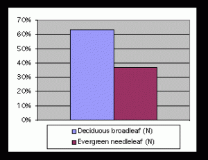
France is a large country in western Europe with a wide diversity of topographic and climatic conditions and a correspondingly diverse flora and fauna. Although it has one of the largest forest resources in Europe, forest and other wooded land accounts for just less than a third of France´s land area; this is less than the European average. The main forest regions in France are the massif central, Alps, Jura, Vosges, Alsace-Lorraine and the Landes in the south-west, which is the largest man-made forest in Europe (in the 19th century for dune stablization and resin tapping). Broadleaved species account for nearly two thirds of the growing stock volume. Oaks and beech are the most important broadleaved species, but there are many others including hornbeam, poplars and sweet chestnut. Pines, Norway spruce and Douglas fir (an introduced species) are the commonest coniferous species. Most of the forest is available for wood supply; around half of it is high forest, the remainder coppice and coppice with standards. There is steady expansion of forest onto former agricultural land through natural extension and afforestation. Net increment is appreciably higher than fellings, with a consequent expansion in the growing stock. Most of the forest is classed as semi-natural, with a relatively small share as plantations; there is very little forest undisturbed by man. One quarter of the forest is publicly owned, partly by the State, partly by communes and municipalities. Several million individuals own most of the remainder, with some forests belonging to private institutions. Besides wood production, hunting, recreation and the collection of non-wood products are important forest functions, as well as soil protection in hilly areas.
Forest Types
Geographic Description
The French Republic is the largest country of Western Europe with an area of 549 190 km2. It is bounded on the north by the English Channel, the Strait of Dover, and the North Sea (which separate it from Great Britain); on the north-east by Belgium, Luxembourg, and Germany; on the east by Germany, Switzerland, and Italy; on the south-east by Monaco and the Mediterranean Sea; on the south by Spain and Andorra; and on the west by the Bay of Biscay (an arm of the Atlantic Ocean). The country is about 965 km north to south and 935 km from east to west. The island of Corsica lies in the Mediterranean Sea to the south-east, off the coast of Italy.
The Brittany-Normandy hills in the north have low, rounded hills and rolling plains. The soils are generally poor, although there are some fertile areas along the coast. The flat or rolling plains of northern France, on the other hand, have an average elevation of about 200 m and highly fertile soils. The area centring on Paris is a large circular basin drained by the Seine and other major rivers. France shares the Ardennes Mountains in the north-east with Belgium. The Rhine Valley bordering Germany has steep slopes and flat bottom lands. In the south-west are lowlands drained by the Garonne River and its tributaries. Inland are rolling plains.
In the south central part of the country lie the central highlands, or Massif Central. The soils in the region are poor except in some of the valleys. Massive mountains, including parts of the Alps and the Jura, are located along the border with Switzerland and Italy, many with elevations exceeding 4 000 m. The highest point in France is Mont Blanc at 4 807 m. The Pyrenees Mountains extend along France’s border with Spain, with many peaks above 3 000 m.. Between the central highlands and the foothills of the Alps, the Mediterranean lowlands and the Rhone-Saone Valley region have productive soils.
The island of Corsica is hilly and mountainous with generally poor soils and a steep, rocky coastline.
The climate of France is generally temperate, but there are large regional differences. Westerly winds that blow in from the Atlantic strongly influence the climate of the western coastal regions, which have a rainy climate with cool winters and mild summers. The Mediterranean coast has an almost semitropical climate, with dry summers and mild winters. Much of the rest of the country has a more continental climate, with cold winters and hot summers.
The average daily temperature range in Paris is 1° to 6° C in January and 15° to 25° in July with an average precipitation of 620 mm per year. At Marseille, on the Mediterranean coast, the daily average is 2° to 10° C in January and 17° to 29° C in July with an average of 550 mm of precipitation annually. The mountains receive more precipitation, with heavy snowfalls at the upper elevations.
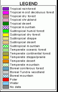
Ecological Zones
Forest Industry
Management
French forests are managed on the basis of a long tradition of sustainable and multi-purpose management principles. The total standing volume is about 3 billion m3. Annual growth of forests (Net Annual Increment) in France amounts to nearly 95 million m3, which makes about 6 m3/ha. This figure is higher than the average for Europe. In an average year, the total annual cut is about 55-60 million m3 (production of commercial wood is about 30 million m3). Roughly three quarters of the forest in France is privately owned, the remainder belongs to the State or to local authorities. Private forests, belonging to several million landowners vary enormously in terms of size and type. About 15 % of forests are owned by 11 000 communes and other local authorities, for the most part in mountainous districts. A network of biological reserves promotes the conservation and study of the ecological environment.
Forest Map