Forest Resource
Overview
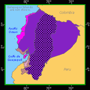
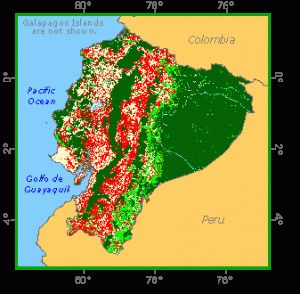
Ecuador is well-forested with more than 40 percent forest cover of the total land area. The country can essentially be divided into three ecological regions: a rich agricultural coastal plain west of the Andes; high-elevation valleys through the mountainous centre of the country; and forested plains in the east. The majority of forests are in the eastern, Amazonian region and mainly comprise lowland humid tropical rainforests comprising several thousand species. Commercially important tree species include Balsa (Ochroma lagopus), Cedrela fissilis and Virola spp. while the alluvial plains, support great concentrations of palm species. Montane forests occur on both sides of the Andes, while the coastal plain harbours areas of tropical rainforest (notably, Protium spp. and Dacryodes spp.) in Esmeraldas province, and dry forests in the south. Around 17 percent of Ecuador´s territory is protected in a network of more than 20 national parks and reserves. One of the most important is the island of Galápagos. Ecuador has forest plantations based mainly on eucalyptus species.
Forest Types
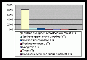
+21,242 ac Needleleaf (T)
Geographic Description
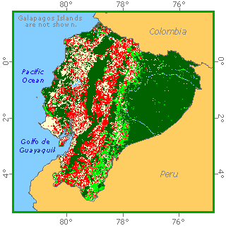
The Republic of Ecuador, located in north-western South America, is bounded by Colombia on the north, by Peru on the east and south, and by the Pacific Ocean on the west. The country also includes the Galápagos Islands (Archipiélago de Colón) in the Pacific, about 965 km west of the mainland. Ecuador, as its name implies, straddles the equator and has an area of 283 560 km2.
Despite its small size, Ecuador has a great variety of environmental conditions as a result of two major factors: first, the presence of the Andes, which divide the country from north to south, and second, the cold, dry Humboldt current, which is responsible for xerophytic vegetation found along the southern coast and reaching roughly as far as the equator.
The coastal plain along Ecuador’s Pacific coast covers a little more than a fourth of the country. It was formed by alluvial deposits from the mountains and ranges from 20 to 160 km wide. In the north, it is wet and swampy. In the south, near Peru, it is a desert thanks to the drying effect of the Humboldt current. In between, tropical forests cover much of the lowland, although some of it has been cleared for farms.
The highlands of the Sierra make up about another fourth of Ecuador. Two parallel ranges of the Andes Mountains extend the length of the country from north to south with high plateaus between them. Mountain peaks rise over 6 000 m, some of them are active volcanoes.
To the east, the Oriente lowlands cover the remaining half the country. Thick tropical forests cover the eastern foothills of the Andes and part of the Amazon River Basin. The rivers draining the Oriente, including the Napo and the Pastaza, are part of the Amazon River system. The region is mostly undeveloped.
The Galapagos Islands cover about 7 800 km2. Most of the islands are volcano peaks, some of which rise to 1 500 m. The five largest islands are Isabela (Albemarle), Santa Cruz (Indefatigable), San Cristobal (Chatham), Fernandina (Narborough), and San Salvador (James).
The coastal region and the Oriente are generally hot and humid, with a mean annual temperature of about 24° C. Temperatures in the Sierra are cooler, depending on the elevation. Quito, some 2850 m above sea level, has an average annual temperature of 13° C. The climate of the Galapagos Islands is moderated by the cool Humboldt Current. Rainfall averages 1 400 mm, although over 2 000 mm may fall in the Oriente. The southern coastal lowlands receive much less rainfall, as do the Galapagos Islands
Ecological Zones
Forest Industry
Resources Forest cover Vegetation
Natural Woody Vegetation Description
Closed Forests
Broadleaved
Closed pure or almost pure forests:
Four concentrations of mangroves are found along the Pacific coast. These are as follows from north to south: Ancon Bay (on the border with Colombia), Cojimies Bay, Caraquez Bay, and the group around the Gulf of Guayaquil (as far as Peru) and Puno Islandthe largest and most intact stand. Some mangroves are also found in the Galapagos Islands. Patches of Mora sp. are found behind the mangroves in the north-west, as they are in Colombia. In fresh water there are forests of Dialyanthera sp. (Acosta-Solfa, 1961; Perfumo, 1974) with Campnosperma panamensis, Symphonia globulifera, Pterocarpus officinalis, etc.
Coniferous
Podocarpus trees are found at the sub-Andean level (approximately 800 to 2 800 m) and are predominant in some stands.
Mixed
These are the largest forests in the country and correspond to the various levels of altitude up to 2 800 m. They can be divided as follows in decreasing order of size:
- Closed mixed forests in the east (approximately 80% of the country’s broadleaved forests). Known as “hylea amazonica”, this vegetation is found east of the Andes in Venezuela, Colombia, Ecuador and Peru, and corresponds mainly to Holdridge’s (1967) “tropical moist forest” life zone. Palm stands and swamp forests are found within it along rivers.
- Rainforests in the north-west (mainly in Esmeraldas province). Rainfall increases with altitude, ranging from 1 500 to 3 000 mm at sea-level up to 6 000 mm and more at 800 m. The most common commercial species in these forests belong to the Burseraceae family, Protium sp., and Dacryodes sp., the Laureaceae, Brosimum utile, Inga sp., Pourouma chocoana and kapok Ceiba sp.
- Mixed forests on the lower and upper levels of the Andes, on the western and eastern slopes and in the mountains towards the Andean high peaks, including cloud forests with a floristic composition that differs significantly from one slope to the other. Extraction is impossible in most of these forests because of the terrain. It is interesting to note the presence of Polylepis sp. up to very high altitudes (4 340 m in one place on the Andean crest (Putney, 1976) and the presence in the upper level of the Andean forest (2 800 to 3 300 m) of patches of surales, surillos, moyas and tundas, which are “representatives of true bamboos” (Acosta-Solfa, 1961).
- Dry (deciduous) forests along the central and southern coast (Manabí, Los Ríos and Guayas provinces) with Cordia alliodora, Pseudosamanea guachapele, Tabebuia sp. and various Bombaceae Ceiba sp., Bombax sp, with balsa Ochroma lagopus in the moister areas. (Acosta-Solfa, 1961).
Open forests
Broadleaved
There are open forests along the central and southern parts of the coast, classified in the UNESCO system as “drought-deciduous broadleaved lowland woodland” and “purely deciduous thorn woodland”, and as “coastal savannah” by Acosta-Solfa (1961), with Acaciasp., Prosopis inermis and patches of Tabebuia sp. They correspond mainly to the “tropical dry forest” and “subtropical dry forest” life zones.
Other wooded land
Shrubs
Scrub is found in relatively dry conditions in various places along the coast and in the mountains. It is found at the lower level mainly in Los Ríos, Guayas and Manabí provinces, stretching south to the dry Peruvian coast (“tropical” and “subtropical desertic scrub” and “tropical” and “subtropical thorn woodland”). Typical locations are the Guayas peninsula and the foot of the Colonche Mountains. The Andean level, especially the high peaks, has scrub, as do the inter-Andean valleys, for example Malcatos and Vilcabamba, where Cactaceae are common (Acosta-Solva, 1961). The vegetation of the Galapagos Islands (an “arid zone”) is made up essentially of cactus scrub and sometimes – in ravines – of scrub with trees such as Bursera graveolens, Coroton scouleri and Acacia spp. Small closed forests are found only on the upper level (at an altitude of over 180 m).
References
Acosta-Solfa, M. (1961). Los bosques del Ecuador y sus productos. Publicacionescientmficas, Quito.
Holdridge, L. R. (1967). Life Zone Ecology. Centro de Ciencias Tropicales, San José.
Perfumo, L. R. (1974). La región forestal del Noroccidente: Panorama actual y perspectivas que ofrece. Proyecto PNUD/FAO/ECU/71/527, Documento de Trabajo No. 7, Quito.
Putney, A. D. (1976). Informe final sobre una propuesta estrategia preliminar para la conservación de áreas silvestres sobresalientes del Ecuador. Dirección de Desarrolly Forestal, Quito
Forest Map
Specific areas
Galápagos Islands
Description of the natural woody vegetation
The Galápagos Islands lie on the equator in the eastern Pacific about 900 km west of Ecuador. The archipelago includes 45 named volcanic islands; the six largest range from 4 670 km2 (Isabela) to 171 km2 (Floreana) and are as high as 1 707 m (Isabela). The climate is characteristically warm and wet from January through June during the El Niño season and cool and dry from July to December (called the garúa season). The varied topography and moisture regimes allow for a wide range of woody vegetational types, including mangrove swamps, arid scrublands and montane and cloud forests. The following description of vegetation types is derived from Mueller-Dombois and Fosberg (1998) and Wiggins and Porter (1971).
Closed broadleaved forests
Mangrove Swamp
Low-growing, usually closed, evergreen mangrove swamps occur in sheltered places where mud and sand deposits accumulate. These species-poor communities feature four mangrove species: Avicennia germinans (black mangrove), Conocarpus erecta (button mangrove), Laguncularia racemosa (white mangrove, which on favorable sites can grow up to 25 m tall) and Rhizophora mangle (red mangrove). Rhizophora is occasionally found on intertidal rocky shores.
Scalesia Moist Forest
This zone of moist evergreen forest occurs above transition-zone forest and below Miconia scrub and forest and is dominated by one of three arborescent species of Scalesia (S. cordata, S. microcephala, S. pedunculata) that reach 15 to 20 m in height. Other important trees in this forest are Pisonia floribunda, Psidium galapageium and Zanthoxylum fagara. Shrubs form a prominent understory and include Baccharis gnidifolia, Darwiniothamnus tenuifolius, Desmanthus virgatus, Duranta dombeyana, Psychotria rufipes and Tournefortia rufosericea. Ground herbs and ferns are numerous, as are lianas and epiphytes; the latter survive the dry season because of heavy fogs prevalent in the uplands during that time of year.
In areas disturbed by feral herbivores, woody species such as Cinchona succirubra, Persea americana, and Psidium guajava have become naturalized.
Open broadleaved forests
Arid-zone Scrub and Forest
An open, xerophytic forest or scrub occurs inland from the littoral zone and extends upslope to as much as 80 to 100 m on the southerly slopes and 300 to 400 m on leeward faces. This distinctive thorn forest is dominated by arborescent and shrubby species of Opuntia and Jasminocereus thouarsii. Acacia rorudiana and Scutia pauciflora are other thorny, woody species. Some sections of this zone are dominated by deciduous forests of Bursera graveolens or evergreen forests of Croton scouleri. The open nature of this forest is dictated by differences in substrate texture and by fractures and crevices in the volcanic landscape. This vegetation type is also the main cover on some of the smaller islands.
Transition-zone Forest
This forest does not have a particularly distinctive assemblage of species. It includes elements from both the arid zone below and the moister Scalesia zone above. The trees are taller and more closely spaced than in the arid zone and the understory more developed and richer in species. The main tree species are Bursera graveolens, Cordia lutea, Piscidia carthagenensis, Pisonia floribunda, Psidium galapageium and Tournefortia pubescens. Because Bursera often forms nearly pure stands in this zone, the forest is semi-deciduous during the dry season.
Miconia Scrub and Forest
This zone of gradually diminishing rainfall, generally between 400 and 600 m elevation, is a transition from the tall Scalesia forest to an open forest or closed scrubland on acidic soils. In this zone Miconia robinsoniana may form monodominant stands of intertangled branches 3 to 4 m high, as on Santa Cruz. In other areas, it is mixed with other shrubs, including Baccharis guidifolia, Darwiniothamnus tenuifolius, Dodonaea viscosa var. galapagensis, Duranta dombeyana, Macraea laricifolia, Tournefortia pubescens, and Zanthoxylum fagara. Miconia robinsoniana is absent from Fernandina and Isabela, and on these islands the zone is inhabited by Baccharis guidifolia, Darwiniothamnus tenuifolius, Dodonaea viscosa var. galapagensis, and Hyptis gymnocaulos. Plants in the lower part of this zone are densely covered by epiphytic mosses and lichens.
Shrubs
Littoral Scrub
In this zone, influenced by seawater and salt spray, common woody halophytic species growing on sand, boulder beaches, or basalt rock include 2 to 3 m tall shrubs of Grabowskia boerhaaviaefolia and Lycium minutum. Also present are Atriplex peruviana, Cryptocarpus pyriformis and Nolana galapagensis.
Highland Scrub
Upland from the Miconia scrub and forest zone, at 600 m and above, is a highland zone dominated by low-growing sedges, broad-leaved herbs, ferns, mosses, and liverworts. A large tree fern (Cyathea weatherbyana) grows in sheltered areas. A woody scrub community of Pernettya howellii occurs on south-facing, windy slopes. In depressions protected from winds are patches of mixed scrub that include species of Acnistus, Miconia, Psychotria and Zanthoxylum.
References
Mueller-Dombois, D. and F. R. Fosberg (1998). Vegetation of the tropical Pacific islands. Springer-Verlag, New York. 733 pp.
Wiggins, I. L., and D. M. Porter (1971). Flora of the Galápagos Islands. Stanford Univ. Press, Stanford, CA. 998 pp