Forest Resource
Overview
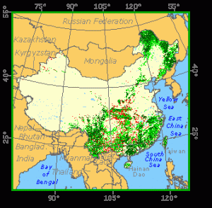
China is, geographically, the world´s third largest country and the most populous. China presently has around 14 percent forest cover, almost evenly divided between coniferous and broadleaved forests. The largest forests are in the northeast and inner Mongolian provinces; the ten southern provinces; and Sichuan and Yunnan provinces. Southern forests are mainly lowland rain forests and monsoon forests. In the north the majority of forests are mixed coniferous. The Chinese Government attaches great importance to forestry development. Afforestation and territory greening have been defined as a common duty of society. China has the world´s most extensive plantation estate, in excess of 20 million hectares The country is also implementing a number of large-scale shelterbelt programmes to protect against erosion and desertification. China has around 800 nature reserves covering more than 6 percent of the country´s land area.
Forest Types
+268,983 ac Semi-Evergreen Moist Broadleaf (T)
+223,041 ac Sclerophyllous Dry (N)
Geographic Description
The People’s Republic of China is the world’s third largest country in area (after Russia and Canada) and the most populous. It is bounded on the north by the Republic of Mongolia and Russia; on the north-east by Russia and North Korea; on the east by the Yellow Sea and the East China Sea; on the south by the South China Sea, Vietnam, Laos, Myanmar, India, Bhutan, and Nepal; on the west by Pakistan, Afghanistan, and Tajikistan; and on the north-west by Kyrgyzstan and Kazakhstan.
China includes more than 3 400 offshore islands. Its total area is 9 596 960 km2, including Hong Kong, Macau and Taiwan. Hong Kong, formerly a British territory, reverted to China in 1997. Macau returned to Chinese administration in 1999.
China encompasses a great diversity of landscapes and a corresponding variety of natural resources. It ranges from sub-arctic regions in the north and west to tropical lowlands in the south; from fertile plains in the east to deserts in the west. China may be divided into six major geographic regions, each of which contains considerable geomorphological and topographic diversity.
- The Northwest region consists of two basins – the Junggar Basin in the north and the Tarim Basin in the south – and the lofty Tien Shan Mountains. The Tarim Basin contains the vast sandy Takla Makan, one of the worlds the driest deserts. The Turpan Depression, the lowest point in China, lies 154 m below sea level. The Junggar Basin, although containing areas of sandy and stony desert, is primarily a region of fertile steppe soils and supports irrigated agriculture.
- The Mongolian Steppe, located in north central China, lies between the Gobi Desert and the Eastern Lowlands It is a plateau region consisting mainly of sandy, stony, or gravelly deserts that grade eastward into steppe lands with fertile soils.
The north central region is characterised by flat-to-rolling plains, divided by several barren flat-topped mountain ranges. Along its eastern border is the higher, rugged, forested Greater Khingan Range.The southern part of the region is thickly covered with loess, a fertile, yellowish soil deposited by the wind. The Huang He and its tributaries have carved out hills and steep-sided valleys in the soft soil. The name Huang He means Yellow River and comes from the large amounts of loess carried by the river.
- Comprising all of Manchuria east of the Greater Khingan Range, the Northeast region incorporates the Manchurian Plain and its bordering uplands. The plain has extensive tracts of productive soils. The uplands are hilly to mountainous, with numerous broad valleys and gentle slopes. The highest hills are the Changbai Mountains (Long White Mountains) along the Korean border. To the north, the Amur River forms the border with Russia.
- North China lies between the Mongolian Steppe on the north and the Changjiang River Basin on the south and consists of several distinct topographic units. The Huangtu Plateau in the north-west is formed by the accumulation of loess. The Huabei Pingyuan (North China Plain), the largest flat lowland area in China, consists of fertile soils derived from loess. Located to the east, the Shandong Plateau on the Shandong Peninsula consists of two distinct areas of mountains flanked by rolling hills. To the south-west are several mountain ranges that constitute a barrier to north-south movement.
- The South China region incorporates the Changjiang (Yangtze) River valley and the topographically diverse regions to the south. The Changjiang valley consists of a series of basins with fertile alluvial soils. The lowlands are criss-crossed with waterways, both natural and artificial, and dotted with lakes. The Sichuan Basin, located to the west, is enclosed by rugged spurs of several mountain ranges and constitutes a relatively isolated area of hilly terrain.
The highlands of South China extend from the Tibetan Plateau (Qing Zang Gaoyuan) east to the sea. In the west the deeply eroded Yunnan (Yungui) Plateau is bordered by a series of mountain ranges separated by deep, steep-walled gorges.To the east are the largely deforested and severely eroded Nan Ling hills, and along the coast are the rugged South-eastern Highlands, where bays with numerous offshore islands provide good natural harbours.
Lying south of the Nan Ling hills is the Xi Jiang Basin, predominantly a hilly area with infertile soils; fertile, flat-floored alluvial valleys, however, border the numerous streams of this region. The broad delta plain of the Zhu Jiang (Pearl River) is sometimes called the Canton delta.
- The Tibetan Plateau, in the remote south-west, is a high, mountain-rimmed plateau, the world’s highest, with an average elevation of about 4 510 m. The Himalayas lie to the south, the Pamir Mountains and the Karakorum Range to the west, and the Qilian and Kunlun Mountains to the north. Mount Everest, the highest peak in the world at 8 848 m, is on the border with Nepal.
The surface of the plateau is dotted with salt lakes and has a number of mountain ranges. The plateau is the source of many of the major southern and eastern Asian rivers, including the Indus, Ganges, Brahmaputra, Mekong, Changjiang (Yangtze), and Huang He (Yellow River). The landscape is bleak, barren, and rock-strewn.
All the major river systems of China, including the three longest – the Changjiang, Huang He, and Xi Jiang – flow in a generally western to eastern direction to the Pacific Ocean. In all, about 50 percent of the total land area drains to the Pacific. Only about 10 percent of the area drains to the Indian and Arctic oceans. The remaining 40 percent has no outlet to the sea and drains to the arid basins of the west and north, where the streams evaporate or sink into the ground.
The northernmost major stream of China is the Amur River (Heilong Jiang), bordering Russia. The Songhua and Liao rivers and their tributaries drain most of the Manchurian Plain and its surrounding highlands. The major river of North China is the Huang He, subject to periodic flooding. The Changjiang River of central China has volume at least ten times that of the Huang He and drains a large area, entering the sea at Shanghai. The Xi Jiang, the most important river system of southern China, enters the ocean at the port of Guangzhou (Canton).
Most of the important lakes of China lie along the middle and lower Changjiang Valley. The two largest are Dongting Hu and Poyang Hu. Tai Hu is the largest of several lakes in the Changjiang delta, and Hongze Hu and Gaoyou Hu lie just to the north of the delta. There are numerous saline lakes in the Tibetan Plateau. The largest is the marshy Qinghai Hu. Other saline lakes occur on the Mongolian Steppe.
As would be expected for such a large country, China has a variety of climates. The Asian monsoon is the primary influence. In winter, cold dry winds blow south-east from central Siberia, bringing low temperatures to all regions north of the Changjiang River and drought to most of the country.
In summer, warm moist air flows inland from the Pacific Ocean, producing rainfall from cyclonic storms. Because of this, summer is the moister season throughout most of China. However, precipitation declines rapidly with increased distance from the sea and to the lee of mountains. The desert basins of the north-west receive little moisture. Summer temperatures are remarkably uniform throughout most of the country, but in winter the temperature difference is much more pronounced.
From the Changjiang Valley southward, China has a subtropical climate and even a distinctly tropical climate in the extreme south. Summer temperatures in this region average 26° C. Average winter temperatures decline from about 18° C in the tropical south to about 4° C along the Changjiang River. Typhoons often bring strong winds and heavy rains to the coastal areas between July and November.
The mountainous plateaus and basins in the south- west also have subtropical climates, but with considerable local variation. Summers are cooler but, since the Siberian winds do not usually reach this far south, winters are mild. The Sichuan Basin is noted for high humidity and cloudiness. Rainfall, especially abundant in summer, exceeds 1 000 mm annually throughout southern China.
North China, with no mountain ranges to form a protective barrier against the flow of air from Siberia, has cold, dry winters. January temperatures range from about 4° C in the extreme south to about -10° C north and west of Beijing. July temperatures generally exceed 26° C and in some areas can approach 30° C. Annual precipitation totals are less than 760 mm, almost all occurring in the summer and decreasing to the north-west. However, there is considerable variability from year to year.
The climate of Manchuria is similar to, but even colder than, that of North China. January temperatures average about -18° C over much of the Manchurian Plain, and July temperatures generally exceed 22° C. Rainfall, concentrated in summer, averages between about 510 and 760 mm in the east, declining to about 300 mm to the west.
Desert and steppe conditions prevail in the Mongolian Steppe and the north-west. January temperatures average below -10° C everywhere except in the Tarim Basin. July temperatures generally exceed 20° C. Annual rainfall totals less than 250 mm, and most of the area receives less than 100 mm.
Because of its high elevation, the Tibetan Plateau has an arctic climate with July temperatures below 15° C. Annual precipitation totals less than 100 mm.
The island of Taiwan, located off the coast of China, is bordered on the north by the East China Sea, on the east by the Pacific Ocean, and on the south by the South China Sea. Thickly forested mountains, the Chungyang Range, run from north to south and cover about half of Taiwan. The highest peak, Yü Shan (Mount Jade), rises 3 997 meters above sea level.
Along the eastern coast, the mountains often drop sharply to the sea, at some places in precipitous cliffs that fall up to 760 m into the Pacific Ocean. Short, swift rivers have cut gorges through the mountains. In the west, the mountains slope to gently rolling hills and fertile, level land.
Taiwan’s climate is subtropical to tropical, and rainfall is abundant. Summers are hot and humid, with an average temperature of 28° C. The north is somewhat less wet in summer, while southern Taiwan receives heavy precipitation from the south-west monsoon. Typhoons often occur between June and October.
Winter lasts from December until February but is mild, with an average January temperature of 18° C. The average annual precipitation is about 4000 mm. During winter, the north-east monsoon brings heavy rain to northern Taiwan.
Forest Industry
Resources Forest cover Vegetation
Natural Woody Vegetation Description
Introduction
China is primarily located in temperate and subtropical climates, with only a small area in southernmost China belonging to the tropical region. Vegetation in China is strongly influenced by topography and the unique summer monsoon systems. Generally, the western two-thirds of China are at high altitudes, descending from west to east. In this large region, moisture availability is low and the land is largely arid. Eastern China is within the reach of both the Pacific and Indian monsoon systems, with ample precipitation on the plains.
The types of natural vegetation and their floristic composition are very diverse. There are about 2,500 species of forest trees in China. Many are useful trees, such as tung-oil trees, camphor trees, lacquer trees (Rhus vernicifera), Star Anise (Ilicium verum), Haupo (Magnolia officinalis) and privet (Ligustrum japonicum). The formation of China’s mosaic-like vegetation landscape mainly results from the fact that during the Pliocene-Pleistocene period the area covered with glaciers was comparatively small and fragmented. Also, the lack of insurmountable topographic barriers between the tropical, temperate, and semi-frigid zones, the alternating winter and summer monsoons and the frequent occurrences of cyclones, all contribute to the medley of tropical and temperate plants of China.
The country’s long history has had a profound impact on the state and distribution of the natural woody vegetation. Nearly all suitable land has been developed for purposes of agriculture, urban areas, industry, and fibre plantations. Only mountains and inaccessible regions in the west have preserved tracts of natural woody vegetation, and often in these cases, the natural woody vegetation is highly fragmented. On the other hand, woody vegetation in China has its unique characteristics: The overwhelming majority of China’s natural forests are closed forests, the evergreen and deciduous/evergreen forest/shrub vegetation in southern China is unique in the world, and the number of endemic woody species is high.
Closed Forests
Broadleaved
In the three north-eastern provinces and a large region of plains north of the Changjiang (Yangtze) River, the general climate is from cold-temperate to warm-temperate, with cool to cold winters and hot, humid summers. This region is predominantly northern conifer forests or mixed forests. However, in the mountains, closed deciduous broadleaf forests are also common. These forests are dominated by oak (Quercus spp.) growing in pure stands or mixed with pine species. The oak forests in the region are usually found at low to medium elevations on southern slopes. Species of Fraxinus, Acer, Tilia, Ulmus, and Quercus, in small stands of low to medium tall trees, are often found in association. In disturbed areas, pioneer forests of poplar (Populus spp.) and birch (Betula spp.) exist along foothills.
Southern China (south of the Changjiang) as well as much of Taiwan Island is a large area with a subtropical, moist climate. The native woody vegetation is evergreen broadleaved forest or deciduous broadleaved forests with an evergreen component. This type of vegetation is considered unique to China. Both coniferous and broadleaf forests exist in this large region, with broadleaf forests occupying less productive sites, often in shrubby form. From north to south, evergreen species increase gradually. Included are species of oak, elm (Ulmus), lime (Tilia), Nyssa, Fagus, Cyclobalanopsis, Castanopsis, Lithocarpus, Cinnamomum and others.
Similar species, together with more tropical evergreen species, continue into the much smaller tropical monsoon forest region, mainly Hainan Island and areas immediately north. Forest cover in this region is primarily in the form of man-made tropical plantations of rubber and eucalyptus. Fragmented natural woody species are evergreen to drought-deciduous, and are often shrubby. A sample of genera found in this region includes Heritiera, Amesiodendron, Vatica, Diospyros, Lithocarpus, Podocarpus, etc. The only closed tropical rainforests are found on the southern tip of Taiwan Island.
Coniferous
Closed coniferous forests in China may be described in three general types: Deciduous conifer larch forests in the northernmost mountains in north-east China, spruce and fir forests at high altitudes in the mountains from Northeast to Southwest, and pine forests in southern China.
Larch forests (mainly Larix gmelini) are distributed on slopes of the northern part of the Daxinganling Mountains in Northeast China. These forests are really part of a continuous boreal forest zone extending from Siberia in Russia. The forests are slow growing, and they form large areas of pure stands of tall trees.
Spruce (Picea) and fir (Abies) forests in China are high altitude species. This type of forest is predominantly found on the upper north-facing slopes of all major mountains of the country. Dominant species vary from region to region, and they usually form small, pure stands.
Natural closed pine forests are widespread in China. In the north-east, the dominant species are Pinus koraiensis and P. sylvestriformis forming either pure or mixed stands with the deciduous broadleaf species mentioned earlier. From northern China’s low mountains to central and southern China’s hilly lands, the following representative species find their respective natural ranges of habitat: P. tabulaeformis from north-east to north-central China, P. massoniana from the Yellow and Changjiang River plains to south-central China, and P. yunnanensis in southern China. It should be noted that these species are now more often planted than naturally regenerated and, in many cases, it is difficult to distinguish what is natural and what is man-made.
Furthermore, there are some native species in China that do not form large stands but play important roles in their respective ecosystems. These species include species of Thuja and Taxus as well as an important refuge species, Metasequoia glyptostroboides. Chinese fir (Cunninghamia lanceolata) is native to China but is now widely used in south-eastern China as a plantation species.
Mixed
The only large area that is truly the habitat of closed mixed forests in China is in the north-east in the mountains of Xiaoxinganling. In this region, mixed forests exist of Pinus koraiensis and Quercus mongolica, with associated species of Picea, Abies, Betula, and Populus. Once disturbed, this ecosystem would degrade into Populus and Betula second growth forests until enough shading is established.
Bamboo Palms
Most of the country south of Changjiang is the natural habitat for many bamboo species. Although today bamboo stands are usually planted with intensive management practices, natural bamboo formations still exist in the mountains. Important plantation species are Phyllostachys edulis and Bambusa emeiensis. These two species are mostly used as material for construction and other utility purposes.
Natural bamboo stands are formed with such representative species as Arundinaria amabilis, Indosasa shibataeoides, and several species of Bambusa as well as Phyllostachys. These bamboos can be found either in single-plant stands or clustered bamboo stands, distributed on mountain slopes or along riverbanks.
Open forests
Broadleaved
Ecologically, today’s China does not support a large presence of open forest lands, either conifer or broadleaf. If any, open broadleaf forests may be found in north-west China in the snow-fed foothills of the Tianshan Mountains, usually along river valleys. Species in this region are from the genera Malus, Armeniana, Crataegus, etc., as well as poplar and birch riparian woodlands.
Coniferous
Ecologically speaking, there is no open coniferous forest in China.
References
Hou, H.Y., Zhao, D.C., Sun, S.Z., Wang, S.Q., and Chen, S.P., 1979. Vegetation Map of China, scale 1:10,000,000. Science Press, Beijing.
Hou, H.Y., (editor). 1979. The legend to the Vegetation Map of China. Science Press, Beijing, 12 p.
Zhu, Zheng-de, 1992. Geographic distribution of China’s main forests. Monograph, Nanjing Forestry University. Nanjing, China. 54 p.
Forest Map