Forest Resource
Overview
Brunei Darussalam is a small sultanate in the north of the island of Borneo, surrounded by the Malaysian State of Sarawak. Brunei is heavily forested with the dominant forest type being mixed dipterocarp lowland rainforest. Brunei also has small areas of peat-swamp forest, keranga forest and mangroves. The majority of (very limited) logging operations are carried out in the peat swamp forests with ramin (Gonystylus spp.) the most important timber species. All of the forest land in Brunei belongs to the State. Brunei has a significant area of forest land in legally protected reserves.
Forest Types
Geographic Description
Brunei Darussalam is situated in the north-western part of the island of Borneo, between longitudes 114 23´ and 115 23´ E and latitudes 4 and 5 5´ N, covering a total area of 5 765 km2. It has a common border with Sarawak, one of the two eastern states of Malaysia, which also divides Brunei Darussalam into two parts.
The western part of Brunei Darussalam, comprising the Brunei/Muara, Tutong and Belait districts, consists predominantly of hilly lowland below 100 m but rising to over 300 m in places on the Sarawak border. The eastern part of the state, comprising the Temburong district, consists predominantly of rugged mountain terrain, rising up to 1 850 m on Bukit Pagon. Near the coast, it has a wide tidal and swampy plain. Narrow alluvial valleys extend up the main rivers. Most streams flow north to the coast, including the Belait River, the longest in the country.
The land surface is developed from bedrock of tertiary age, comprising sandstone, shale and clays. Several factors have influenced the moulding of this surface into its present form, namely the comparatively youthful state of geological erosion, the nature and angle of dip of the strata, and the climatic factors of high rainfall and temperature that maintain a dense forest cover on all landforms and induce deep chemical weathering and rapid erosion.
These factors have contributed to producing a strong undulating ridge-and-valley terrain with universally steep slopes. Erosion occurs even under a forest canopy, but the rate is considerably accelerated when the forest is cleared. Rivers redistribute the sediment washed off the hills to form extensive alluvial plains near the coast. There are extensive swamps, especially in the west and northeast.
Generally, in common with its surrounding neighbours, Brunei Darussalam has a tropical climate. This is characterised by constant high temperature, humidity and rainfall. Rainfall in Brunei normally ranges from about 2 800 mm annually in the lowland areas to over 3 800 mm in many parts of the interior. Temperatures are high throughout the year. The annual extreme range of temperature is 23 C to 32° C, with an average annual temperature of about 27° C. Relative humidity is high, fluctuating between 67 to 91 percent throughout the year.
Forest Industry
Resources Forest cover Vegetation
Natural Woody Vegetation Description
Introduction
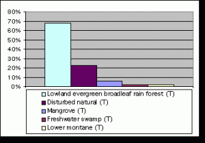
The forests may be ecologically classified under the following five types:
- Mangrove forests found at sea level and characteristically inundated at high tide by brackish water;
- Heath forests found on sandy alluvial soils, usually below 30 m above sea level, but also occasionally on high altitude sandstone ridges in Ulu-Temburong;
- Peat swamp forests found adjacent to the main rivers. These forests merge irregularly into the following types;
- Mixed dipterocarp forests lying immediately above peat swamp forests and extending to above 1 300 m where they give place to montane types;
- Montane forests, which are found only in Ulu-Temburong adjacent to the state border up to 1 800 m.
Species composition and physiognomic characteristics of the forest types closely resemble those of Sarawak and Sabah, summarised below:
Forest Map
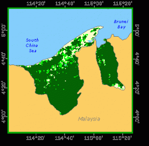
Closed Forests
Broadleaved
Mangrove forest is found only in the more sheltered areas of the coast or in river estuaries. It is of local domestic value for poles, fuelwood and charcoal and is also a source of wood chips. The main commercial species within this type are of the genera Rhizophora and Bruguiera, with seaward fringe species of Avicennia and Sonneratia.
Two types of swamp palm are also included in the mangrove forest type, nipah (Nypa fructicans) and nibong (Oncosperma horrida). Nipah is a general utility species providing local products such as housing thatch, cigarette paper, sugar, alcohol, vinegar and salt. This species frequently occurs in pure stands. Nibong occurs in the drier zone of the mangrove forest.
Beach and fresh water swamps. Beach forests are restricted to sandy coastal soils where they occupy strips seldom more than a hundred meters in width. The main species is Casuarina equisetifolia. Fresh water swamps occur on areas liable to flood during the rain season. These are usually rich in Dipterocarpus warburgii. Shorea gysbertsiana and Dipterocarpus exalatus are prevalent in forests on alluvial soils near rivers. Dipterocarpus oblongifolius is common along streams in hilly country.
Peat swamps cover relatively small areas. Main constituent species are ramin (Gonystylus bancanus), jongkong (Dactylocladus stenostachys), Dryobalanops rappa, Shorea platycarpa, S. scabrida, S. teysmanniana and Hopea pentanervia. Some of these species also occur on poor padang (kerangas) soils. Dryobalanops beccarii often replaces Dryobalanops rappa and Shorea scabrida replaces Shorea platycarpa. These swamps have similarities with dipterocarp forests on high-level alluvium, where common species are Dryobalanops beccarii, Shorea parvifolia, S. leprosula and Hopea beccarii. Neither Dryobalanops lanceolata nor any species of Parashorea are found in these swamp forests.
Mixed dipterocarp forest occupies most of the area from the inland limit of the freshwater peat swamps to the lower limit of the montane forests. In its primary state, this forest generally consists of emergent trees some 60 m in height, a dominant and co-dominant strata having a height of about 45 m, an intermediate layer of trees with canopies between 23 to 30 m, and suppressed vegetation. In some instances, where emergent trees are rare, the forest becomes a three-stratum stand. Ground vegetation is of moderate density and does not seriously impede walking.
The family Dipterocarpaceae, as its name implies, dominates the mixed dipterocarp forest. This genus accounts for 65 to 80 percent of the total stemwood volume of trees having diameters in excess of 30 cm. Non-dipterocarps do not occur with sufficient frequency to be considered important commercial species
Montane dipterocarp forests. The main species are Shorea platyclados, S. venulosa (on ultra basic rocks), S. monticola, S. laevis, Hopea montana, H. dyeri, Dipterocarpus ochraceus, Vatica dulitentis, and V. umbonata.
Keranga forest is generally included as a part of “hill forests” and contains trees of poor form and small size. These forests are generally located on white soils or beach terraces at all elevations or on weathered steep ridges at the higher elevations. The main species are Casuarina, Agathis alba, Dacrydium, Tristania and, infrequently, Shorea albida.
Riverine forest, sometimes described as a distinct forest type, should be more appropriately considered a subtype of the mixed dipterocarp forest. Its area is insignificant.
Other wooded land
Shrubs
The area is insignificant and mainly occurs on rocky outcrops or degraded lands with exhausted soils.
References
Fox, J. E. D. (1978). The natural vegetation of Sabah, Malaysia 1: The physical environment and classification. Tropical Ecology 19(2).