Forest Resource
Overview
Benin is moderately forested with around 42 percent forest cover and most of the remainder of the country classified as “other wooded land”. The vegetation has been heavily influenced by man and significant areas of high forest have been cleared. The majority of remnant closed forest in Benin is in the south-east near Ketou, and comprises semi-deciduous and deciduous forest. Characteristic species include Triplochiton scleroxylon, Antiaris africana and Chlorophora excelsa. The majority of the country is savannah: either regenerating from cleared forest or natural Sudanian woodland. The former is characterised by Anogeissus leiocarpus and Butyrospermum paradoxum, the latter, by Isoberlinia doka.
Benin has a modest plantation estate with Tectona grandis the largest component species. More than 2 percent of the country’s total land area is protected in two national parks (including the trans-national W Park) and a handful of other formally protected areas.
Forest Types

Geographic Description
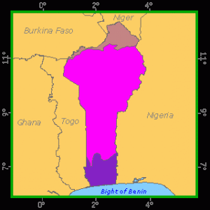
The Republic of Benin borders the Gulf of Guinea in West Africa, lying between latitudes 6° 15´and 12° 25´ N and longitudes 0° 40´and 3° 45´ E. Burkina Faso and Niger border it on the north, while on the east and west it is bordered by Nigeria and Togo, respectively. The country is about 640 km from north to south, while its width ranges from 320 km in the north to 110 km in the south. Its total area is estimated at 112 622 km2.
The coast is flat, low-lying and sandy with inland lagoons and marshes. An area of fertile lowlands called the barre country occurs farther inland, much of which is intensively cultivated. In the far north the land rises to a plateau, with the highest elevation in the country at about 610 m in the rugged Atacora Mountains in the north-west.
Benin’s climatic features reflect those of West Africa in general, with a humid coastal zone along the Atlantic coast, then a transitional continental zone further inland and finally a dry continental zone. Rainfall ranges from about 3 000 mm along the coast to 300 mm or less adjacent to the desert areas. There are generally two wet seasons in the south, from March to July and from October to November, while in the northern part of the country a single wet season lasts from March to November. Temperatures are tropical, ranging from 20° to 34° C over the course of a year. Variations in woody vegetation are primarily a result of climatic influences.
Ecological Zones

Forest Cover
Introduction
Some type of arboreal vegetation covers about 65% of the country. Productivity of most such stands – essentially savannah scattered sparsely with trees – is low. Significant forests, including gallery forests, cover only a small part of the country’s area. However, there are large stretches of relatively closed mixed forest and grassland (“open forest” and “savannah woodland”), which at present constitute the largest reserves of arable land and wood.
Closed Forest
Broadleaved
1, Closed semi-deciduous or deciduous forest
In the coastal zone of Benin, this type of vegetation is represented by the Lama forest, one of the few intact forests surviving in the south of the country and the only one still of any significant size. It lies in the depression of the same name, which is flat and poorly drained, flooding during the rainy season and cracking in the dry season (FAO, 1980). It is a multi-storeyed forest of average height. The upper storey is very open (>30 m high) and dominates an intermediate storey (15 to 25 m high) with a closed canopy. Triplochiton scleroxylon, Antiaris africana, Chlorophora excelsa, Afzelia africana, Ceiba pentandra, Diospyros mespiliformis and Dialium guineense are found here. The understorey is 7 to 10 m high, and the same species occur here, plus large numbers of Drypetes floribunda. The undergrowth is very thick and varied (FAO; 1978, 1980). This forest suffers considerable pressure from the population of surrounding areas.
Between Savalou and Djougou in central-western Benin, a region receiving an average annual rainfall of over 1 300 mm, there are many small stands, usually on slightly higher ridges and often sheltering a village. These are closed multi-storeyed stands with a closed cover and are often degraded as a result of encroaching cultivation and the fires that penetrate them a little further each year. Large numbers of Antiaris africana, Celtis zenkeri, Holoptelea grandis, Chlorophora excelsa and Cola gigantea are found here, and sometimes Triplochiton scleroxylon and Ceiba pentandra. These forest islands have areas of between 50 and 150 ha, and their composition is generally similar to that of the Lama forest, although Afzelia africana is fairly rare in the dominant storey (FAO, 1980).
2. Gallery forests
Gallery forests are found throughout the country right up to the northern border and are fairly regularly spread along permanent watercourses. Their composition is very similar to that of the semi-deciduous forests, and they are also three-storeyed forests in which species with large diameters such as Ceiba pentandra, Chlorophora excelsa, Khaya senegalensis, Diospyros mespiliformis, Vitex domiana and the Elaeis guineensis palm are predominant (FAO; 1979, 1980).
Forest Industry
Open forests
Broadleaved
1. Open forest and savannah woodland
Generally small in area, islands of open forest (in which the crowns provide a 50% to 80% cover) are most often found in savannah woodland on secondary ridges, a location that provides them with some protection from bush fires. Such fires are indeed the origin of open forest, which is a degraded form of the original dry closed forest. These open forests average 7 to 20 m in height with a dominant storey very similar to that of the closed forest. They are found in the central zone, where the average annual rainfall is between 1 000 and 1 400 mm. They contain several species that occur in varying densities throughout the region – Anogeissus leiocarpus, Butyrospermum paradoxum, Daniellia oliveri, Isoberlinia doka and Parkia biglobosa – and have an understorey of tangled shrubs and grassy vegetation (FAO; 1979, 1980).
The term “savannah woodland” is used for formations that are more open than the open forest found throughout the country but which have the same physical appearance, even though their composition, which varies depending chiefly on climate, is somewhat different. Crown cover ranges from 20% to 50% (FAO, 1980). Some of the species found in open forests are also present, although they are more scattered here. Ceiba pentandra and Chlorophora excelsa also occur. The grassy layer, which is more or less unbroken, burns frequently, but not necessarily every year.
2. Tree savannah
Tree savannah consists of an unbroken grassy layer at least 80 cm high that burns each year. It is dotted with trees and shrubs rarely over 7 m in height, forming a broken cover of under 20% (FAO, 1979). Savannah is found scattered throughout the country, though it is less frequent in the coastal zone. Anogeissus leiocarpus, Butyrospermum paradoxum, Daniellia oliveri and Combretum spp. are typical of such vegetation.
3. Periodically flooded open forests
Located in bottomlands, in depressions along watercourses and on the edges of ponds and lakes, these formations are flooded for part of the year. They very often cover small areas.
In the coastal zone, riparian forests are found mainly along the lower reaches of the Ouémé, Zou, Kouffo and Mono Rivers – as is the case of the vestiges of degraded semi-deciduous forest in the Mono and Ouémé valleys. Certain species such as Pterocarpus santaloides and Dialium guineense are common. Small areas of shrub savannah featuring Mitragyna inermis belong in this group, as well as swamp vegetation and occasional mangroves in salty environments (Avicennia africana).
Low floodplains covered with woodland and tree savannah lie along certain watercourses, for example the Pendjari and Niger Rivers, in the dry and central zones. Acacia sieberiana in its arborescent form (12 m tall) and Acacia seyal (with a height of 3 to 9 m) are found here, often in groups that form almost pure islands. Terminalia spp., Mitragyna inermis, Tamerindus indica, Balanites aegyptiaca and Borassus aethiopum are also found (FAO, 1980).
4. Stands altered by humans (FAO, 1980)
The crop-and-fallow complexes in the coastal zone contain large numbers of oil palms (Elaeis guineensis) under which farmers grow their food crops. The palms are often mixed with other trees such as Chlorophora excelsa and Lophira lanceolata, dominating a thick low grassy shrub layer.
Further north, there are fewer palm groves and farmland is scattered with isolated species or small thickets, the remains of the original forests. The most frequent species are Ceiba pentandra and Chlorophora excelsa.
Tree and shrub savannah with large inroads by agriculture is typical of most of the central zone. Crops and fallow areas are dotted with trees from the surrounding savannah left by the farmers, especially those supplying edible fruit such as Parkia biglobosa and Butyrospermum paradoxum, which have given rise to a flourishing trade.
Forest Map

Other wooded land
Shrubs
Shrub savannah is formed of an unbroken grassy carpet with shrubs – usually in large numbers – and some scattered trees. Fire affects these areas most years. Lophira lanceolata and Acacia spp. are the most common shrub species here (FAO, 1979).
References
FAO. 1978. Inventaire d’aménagement de la forêt de Lama. Basé sur le travail de H. Marach. Document de terrain no. 3, FO:DP/BEN/73/014. Rome
FAO. 1979. Inventaire de reconnaissance du centre-nord. Basé sur le travail de H. Marach. Document de terrain no. 4, FO:DP/BEN/73/014. Rome
FAO. 1980 Cartographie du couvert végétal et étude de ses modifications. Système mondial de surveillance continue de l’environnement, Projet pilote sur la surveillance continue de la couverture forestière tropicale basé sur les travaux de R. Baltaxe, J. Guellec et L. Oko. Rapport technique No. 1 UN 32/6 (1102-75-005). Rome.