Forest Resource
Overview
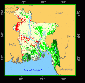
Bangladesh is one of the world´s most densely populated countries and, as a consequence, its forests are subject to heavy demand pressures in terms of both wood production and competing land-uses. Bangladesh has a relatively low proportion of forest cover. A significant area of additional land [to that shown in the chart] is classified as forest land, but is presently without forest cover. Bangladesh´s forests are of three broad types. Mangrove forests in the coastal delta, hill forests in the interior, and a smaller area of inland sal (Shorea robusta) forest. Significant areas of both hill forest plantations and mangrove plantations have been established. A number of protected areas are under the jurisdiction of the Forestry Department, though most of these have been degraded by illegal logging and forest clearing.
Forest Types
Geographic Description
The People´s Republic of Bangladesh covers an area of approximately 144 000 km2 between latitudes 21° and 27° N and longitudes 88° and 93° E at the confluence of two major rivers, the Ganga and the Brahamaputra. It is surrounded by India on the western, northern and eastern sides, by Myanmar on the south-east and the Bay of Bengal on the south. It can be divided into three main geographic zones:
- The hills cover about ten percent of the total area in the east, at the border with Assam, and the south-east. The Chittagong Hill Tracts consist of a series of parallel ridges in a NNW-SSE direction. The ridges rise to an elevation of over 1 000 m. The land between the ridges exhibits sharp-edged, irregular lower hills (250 m elevation). The major river, the Karnafuli, cuts across the main ridges but all its principal tributaries follow the inter-ridge valleys;
- The delta formed by the confluence of the Ganga and Brahamaputra rivers at the Bay of Bengal occupies the southern and south-western parts of the country. The zone extends about 80 km inland from the Bay of Bengal at the mouth of the River Ganga, west to the Hooghly River and across the Indian frontier. The maximum ground elevation is 1.5 m and the land is flooded during the monsoon tides (mid-June to mid-September). The land on either side of the main rivers is laced with a network of channels which vary in width from a few meters to over a kilometer;
- The plains occupy most of the country, consisting of generally level alluvium. This is the most fertile and heavily populated area.
The climate of the whole country is tropical. Average annual rainfall varies from 1 500 mm to 5 000 mm of which a large part falls during the monsoon season. In the hills it varies from 2 150 to 5 000 mm whereas in the delta it is from 1 650 to 1 800 mm. Bangladesh is warm throughout the year. Humidity is high during the monsoon months while the period from November to February is usually dry and relatively cool. In Dhaka the temperature averages about 19° C in January and about 29° C in May. In addition to the normal monsoonal rainfall, Bangladesh is subject to devastating cyclones, resulting in disastrous flooding.
The soil of the Chittagong Hill Tracts is generally coarse, acidic and non-saline, varying in depth and texture. In the delta the soil is a clayey loam lying over alternate layers of clay and sand. In the plain it consists of sandy loam over a thousand meters deep.
Forest Industry
Resources Forest cover Vegetation
Natural Woody Vegetation Description
Closed Forests
Broadleaved
Nearly all remaining forests belong to this category. The following types are distinguished:
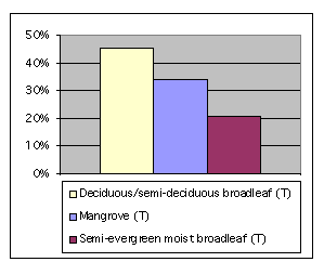
Evergreen and semi-evergreen forests
These forests are located in the Chittagong Hill Tracts (Chittagong and Sylhet districts of the Chittagong division). They are also referred to as “hill forests”. They are closed multistoreyed high forests with trees of diameters up 1.5 m and heights varying from 30 to 60 m. The species considered to be merchantable are garjan (Dipterocarpus spp.), civit (Swintonia floribunda), chundul (Tetrameles nudiflora), narikeli (Sterculia alata), boilam (Anisoptera glabra), tilsul (Hopea odorata), etc. Garjan is an excellent construction timber and civit is good for pulpwood, packaging and plywood. Garjan oil is in demand for lighting, paint and protection of boat bottoms. Several other species are favoured for boat building, house posts and other special uses. Bamboos, mainly muli (Melocanna bambusoides) occur as undergrowth. Other bamboos of commercial importance are mitenga (Bambusa tulda), dallo (Teinostachyium dulloa) and orah (Dendrocalamus longispathus).
Moist deciduous forests
Also known as “inland sal forests”, these cover relatively small areas distributed over the inland plain area. They are predominantly composed of sal (Shorea robusta) occurring in pure patches, sometimes associated with korai (Albitia spp.) in the canopy and kumbhi (Careya arborea) in the lower storey. These forests have their main distribution in the Mymensingh forestry division and the Dacca division, the rest being scattered throughout the northern area of the country. They have been subjected to considerable cutting and encroachment due to their location in densely populated areas.
Tidal forests
These forests consist mainly of mangroves occurring in the delta zone. Most of them are flooded during the monsoon. The bulk of these forests are located in Sunderbans (south-eastern part of the delta region) around Khulna, the rest being found in the district of Chittagong in the south-east part of the country. The predominant tree species are sundri (Heritiera minor) and gewa (Excoecaria agallocha). Less frequent species are passur (Carapa moluccensis var.gangetica), goran (Ceriops roxburghii), kankra (Bruguiera gymnorhiza), keora (Sonneratia apetala), baen (Avicennia officinalis), etc. They are closed forests with a dense canopy. The trees can reach a maximum height of 25 to 30 m but are usually 8 to 15 m high. Tree diameters range between 10 to 20 cm although 45 cm can be reached under favourable conditions. The wood is used for fuel, and is also in demand by the wood industries. The main means of transportation in these forests are rivers and channels (locally called “khals”).
Open forests
Broadleaved
Open deciduous forests
occur on dry exposed southern slopes in the Chittagong Hill Tracts and consist of large trees scattered in a dense undergrowth of evergreen species. Their total area is very small.
References
Douglas, J. J. (1980). Government forest resources and management in Bangladesh. UNDP/FAO Forestry consumption and sector planning project (BDGH/78/010), Planning Commission, Forestry Section, Dacca.
Khattak, G. M. (1979). History of forest management in Bangladesh. The Pakistan Journal of Forestry, July 1979.
Ray, R. G. (1971). Six forest inventories in the Tropics: Nos. 3 and 4, Pakistan. In collaboration with the Canadian International Development Agency, Ottawa.