Forest Resource
Overview
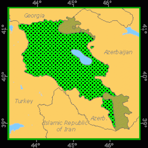
Armenia is a small, landlocked country in the southern Caucasus. Forest and other wooded land makes up only one seventh of the land area, and is located mainly to the north and south of the country. In terms of forest and other wooded land per capita, Armenia is rather poorly endowed. Broadleaved species predominate, accounting for more than nine tenths of the total growing stock. The main species are oaks, beech and hornbeam, with ash, elm, lime and maple also common. Remnants of coniferous forest contain species of pine, yew and juniper. Altogether, there are about 200 species of trees and shrubs. Most of the forest is classified as undisturbed by man and not available for wood supply, more for economic reasons than for conservation and protection reasons. The Forest Code of Armenia (1994) and the law on Specially Protected Territories (1991) provide the main legislative framework for the protection and management of the forest resource. Commercial forestry activities, including wood harvesting, are limited in Armenia, but the collection of fuelwood, fruits, aromatic and medicinal herbs and fodder are important to the population. All forest is State owned.
Forest Types

Geographic Description
The Republic of Armenia is bordered by Georgia on the north, Azerbaijan on the east, Iran on the south, the Azerbaijani exclave of Nakhichevan on the south-west, and Turkey on the west. It lies in the Caucasus Mountains between the Black and Caspian Seas. The land area is about 29 740 km2, mostly in very mountainous uplands with an average elevation of about 1 800 m, extending as high as 4 090 m on Mount Aragats, the highest point in the republic.
Armenia is landlocked but contains about 100 mountain lakes, the largest of which is Lake Sevan, located in the north-east. It covers about five percent of the country and is a popular resort area. Many of the country’s rivers flow into Lake Sevan. The main outlet is the Hrazdan River, which flows south to join the Aras (known in Armenia as the Arax) River, Armenia’s largest and longest river, which separates Armenia from Turkey.
The climate of Armenia varies by altitude but is predominantly dry and continental, with hot summers and moderate winters. January temperatures usually range from -12 to -5 °C and can fall below -30 °C. July temperatures average about 10 °C in the mountains and about 25 °C elsewhere. Precipitation varies by location and is heaviest in autumn. Armenia receives a yearly rainfall of about 200 to 800 mm, rising with elevation. Mountainous areas receive the most precipitation, both in the form of rain and snow. The most arid region of the country is along the Aras River.
Ecological Zones
Forest Industry
Resources
Management
The Forest Code of Armenia (1994) and the law on Specially Protected Territories (1991) provide the main legislative framework for the protection and management of forest resources. All forests in Armenia are state owned, and about one third of the total forest area is in the protected areas. Although there are only limited commercial forestry operations in Armenia, they are still impoverishing the genetic basis through the selection and cutting of the best trees.
Forest Map
