Forest Resource
Overview
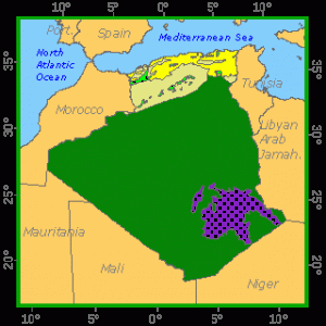
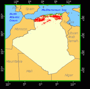
Algeria is lightly forested with less than 2 percent of its area covered by either forest or other wooded land. All of the country´s forest and arable land is in a broad coastal strip, around 400 kilometres wide. The rest of Algeria is Saharan with vegetation comprising sparse Acacia spp. and desert grasses. Northern Algeria has been extensively deforested, with around half the country´s forest area being cleared between 1935 and 1962. The country´s high forests comprise remnant stands of mainly Pinus, Quercus and Cedrus species, mainly on the slopes of the Tell Atlas and the Saharan Atlas. Other forested areas include large tracts of Marquis scrub. Algeria has established an extensive tract of plantation forests as part of its “Green Dam” project to protect against desertification. The plan requires the eventual establishment of a 3 million hectare band of plantations as a barrier to the Sahara. Pinus halipensis is presently the most common species planted. Algeria has an extensive protected area system including 10 national parks. Around 4 percent of the country´s forests are inside protected areas.
Geographic Description
The People’s Democratic Republic of Algeria is bounded on the north by the Mediterranean Sea; on the east by Tunisia and the Libyan Arab Jamahiriya; on the south by Niger, Mali, and Mauritania; and on the west by Morocco. It has a total area of 2 381 741 km2.
Algeria has three major land regions. The northernmost region, the Tell, extends about 1,200 km along the Mediterranean coast and is from about 130 to 320 km wide. It consists chiefly of coastal plains and gently rolling hills, although rugged mountains cover most of the eastern Tell. The Tell Atlas Mountains rise along the region’s southern edge. The country’s principal river, the Chelif (725 km long), rises in the Tell Atlas and flows to the Mediterranean Sea; no permanent streams are found south of the Tell.
The Tell region has a typical Mediterranean climate, with warm, dry summers and mild, rainy winters. Near the sea, temperatures average 25° C in summer and 11° C in winter. Annual rainfall averages 400 mm in the west and 700 mm in the east.
The High Plateau lies south of the Tell Atlas Mountains and ranges from about 400 to 1 300 m above sea level. During rainy periods, large shallow salt lakes called chotts or shotts form on the plateaus, drying to form salt flats. On the southern edge of the Plateau lie the mountains of the Saharan Atlas.
Average temperatures on the High Plateaus range from 27° C in summer to 5° C in winter and rainfall seldom exceeds 400 mm per year.
The Saharan Atlas Mountains are the northern border of the Sahara Desert in Algeria, which comprises more than 90 per cent of the country. Vast areas of sand dunes cover much of the north, while other regions consist of bare rock, boulders, and stones. In the south-east, however, the Ahaggar Mountains tower above the desert floor, cumulating in Mount Tahat, Algeria’s highest point at 3 003 m above sea level.
Daytime temperatures in the Algerian Sahara sometimes soar above 49° C, with annual rainfall less than 130 mm. During the summer, a very hot, dusty wind called the sirocco (also known as the Chehili) blows northward across the region. The desiccating sirocco affects the High Plateau about 40 days each summer and the Tell about 20 days.
Forest cover Vegetation
Introduction
The People’s Democratic Republic of Algeria is composed of two distinct geographical parts: the Atlas mountain system in the north, and the Sahara in the south.
Thus, in the north there is the Tell mountain massif, cut up by valleys and plateaux and separated from the Mediterranean by narrow plains. The High Plateau south of the Tell is an area of steppes between 700 and 1 000 m in altitude, encompassing a number of chotts, shallow salt lakes set in wide depressions. The Saharan Atlas borders the south of the High Plateau, joining up with the Tell in the east of the country.
The Sahara stretches south from the Saharan Atlas at heights of under 500 m. This huge desert area is made up for the most part of ergs (dune systems, such as the Great Eastern Erg and Great Western Erg) and regs (stony deserts). Some mountainous areas (the Tassili Plateau, Hoggar Massif and Eglab Plateau) are found in the far south of the country.
Although Algeria’s geographical position means that it holds a wide range of biotopes, six relatively homogeneous forested regions can be distinguished on the basis of bioclimate, soil type and altitude:
the Algerian-Tunisian High Plateau region in the east, with a semi-arid to arid bioclimate (annual rainfall of 300-700 mm), dominated by Aleppo pine (Pinus halepensis) mixed to varying degrees with holm oak (Quercus ilex). Atlas cedar (Cedrus atlantica) is not found in this zone;
the Kabylie cork oak (Quercus suber) region in the northeast, with humid and subhumid bioclimates (annual rainfall of 700 to over 1 000 mm), stretching to the Tunisian border in the east, and containing most of the country’s cork oak forests as well as the main stands of zeen oak (Quercus faginea), afares oak (Quercus afares) and maritime pine (Pinus pinaster); Atlas cedar is found in a few places (Djurdjura and Babors);
the Constantine and Aurès Plateaux region to the south of the previous region, with a predominantly semi-arid bioclimate (annual rainfall of 500-700 mm), ranging to subhumid or humid in higher places. Aleppo pine is the main species, while holm oak is found on degraded land;
the region comprising Ouarsenis, the central Tell and the Algiers area on the Mediterranean coast, bordered on the south by the High Plateaux and with a subhumid climate (annual rainfall of 500-700 mm). Aleppo pine, holm oak and cork oak are the main forest species here;
the region around Oran, west of the previous region, with a semi-arid bioclimate, containing mainly Aleppo pine in association with thuja (Tetraclinis articulata) and Phoenician juniper (Juniperus phoenicea);
the Saharan Atlas region, constituting the higher land bordering the northern Sahara, with an arid climate (annual rainfall of 300-500 mm), where Aleppo pine, holm oak and Phoenician juniper are found.
The bulk of the forests are found in the first three regions, or the eastern third of the country. They are Mediterranean in type, with the xerophytic nature of the species becoming more marked nearer the Sahara. They are very varied in character as a result of the wide range of natural environments and the many depredations caused by human occupation.
Algeria’s various forests are generally made up of pure stands of one species, and occasionally of mixtures of two or three main species (apart from cork oak-zeen oak or cork oak-maritime pine associations), although there are a number of associations with many secondary species. Conifers, especially Aleppo pine, cover by far the largest area. Cork oak is easily the commonest broadleaved species, followed by holm oak. A huge steppe of alfa (Stipa tenacissima) stretches to the south of the forested regions.
Thus, apart from forests, there are also shrubland, maquis, garrigue, and alfa, esparto (Lygeum spartum) or sagebrush (Artemisia herba alba) steppes, depending on soil type. These are generally degraded forests and cover large areas. Garrigue is found on degraded land on calcareous soil, while shrubland and maquis are found on siliceous soil. Some species are dying out as a result of degradation by humans and animals; for example, Cupressus depreziana is now found only in the Tassili mountains.
The rest of Algeria consists of desert regions (annual rainfall of under 300 mm), with the only tree and shrub formations being found basically in wadi beds and in Saharan mountains above 1 800 m. They consist of small trees and isolated shrubs (e.g. Tamarix) on the edge of wadis, while shrubs and bushes (Tamarix, Acacia, Pistacia atlantica, etc.) are more common in the Saharan mountain zones.
Forest Industry
Closed Forests
Broadleaved
1. Oak forests
Predominantly cork oak forests (Quercus suber) are generally pure stands, mixed here and there with holm oak, and more often with zeen oak at higher altitudes and maritime pine in the northeast (the Kabylie region). Cork oak is the most common broadleaved species in Algeria, especially in the northeast.
Reaching heights of 6 to 12 m, cork oak has two different forms, depending on the bioclimatic zone in which these stands are found. In subhumid and humid zones, forests are very closed, with an extremely bushy undergrowth 2 to 4 m high, and the presence of many species (Quercus faginea, Q. afares, Prunus avium, Pistacia atlantica, Cistus spp., Cytisus spp., etc.). In semi-arid zones, on the other hand, forests are open, poor in woody undergrowth (Cytisus linifolius, Sarothamnus baeticus, Ulex spectabilis, etc.), and with a well-developed seasonal herbaceous layer.
Predominantly holm oak forests (Quercus ilex) are found in mountain zones (400-2 400 m) and in every type of bioclimate, although this species is particularly common in the northwest of the country. It is the second most widespread broadleaved species in Algeria and reaches its maximum height (about 15 m) in humid zones.
Holm oak forests have two forms, depending on climatic zone. In arid areas (Saharan Atlas and south of Oran), they form an open, low canopy with many species in the dominant storey (Juniperus phoenicea, Juniperus oxycedrus, Pistacia terebinthus, P. atlantica, etc.), while in subhumid and humid areas they form a high, very closed canopy, with such species as Pinus halepensis, Olea europea, Quercus faginea, Juniperus oxycedrus, Taxus baccata and Sorbus terminalis, and an undergrowth made up mainly of mastic (Pistacia lentiscus), Cistus sp. and Crataegus monogyna.
Forests with a predominance of other species of oak (zeen oak/Quercus faginea and afares oak/Quercus afares) are usually thick and closed, with a poorly developed undergrowth. They are found in the coolest parts of cork oak stands, and also at higher altitudes.
In the tree layer, zeen oak is often combined with other species such as Quercus suber, Quercus ilex, Sorbus terminalis and Acer campestre. Afares oak is closely related to zeen oak and is found only in Algeria, mainly on relatively dry mountain slopes. It forms a thick cover, and its undergrowth is made up of the same species as that in zeen oak forests.
Coniferous
Predominantly Aleppo pine forests (Pinus halepensis) occur at low altitudes, primarily on sedimentary soils in semi-arid zones, although they are also found in all the forested regions of the country. Aleppo pine is generally mixed with holm oak and Phoenician juniper, and such stands take three different forms, depending on geographical zone. On the driest soils in the coastal and subcoastal zones (humid and subhumid climates), it is found in association with Phoenician juniper, mastic, kermes oak (Quercus coccifera), wild olive, Cistus sp., etc. In the Tell mountains, it occurs with Quercus ilex, Pistacia terebinthus, Juniperus oxycedrus, etc. In the drier mountain zones (Saharan Atlas), the undergrowth is abundant and other species are added to those of the preceding type (phillyrea [Phillyrea angustifolia], Crataegus monogyna, etc.).
Predominantly maritime pine forests (Pinus pinaster) are natural forests found in the northeast of the country (the Kabylie region). Maritime pine colonizes degraded cork oak stands, and its undergrowth is in fact identical with that of cork oak forests.
Predominantly Atlas cedar forests (Cedrus atlantica) occur as scattered islands at higher altitudes (the central Tell, Kabylie and Aurès regions) in humid to subhumid zones, and may have two forms, depending on conditions. The humid form is closed, with an undergrowth of holm oak, and the associated species are mainly Juniperus oxycedrus, Fraximus dimorpha, Ilex aquifolium, Quercus faginea and Cytisus sp. Other species -mountain juniper (Juniperus thurifera), Sorbus aria, yew, Montpellier maple (Acer monspessulanum), etc.- appear in relatively arid zones.
Open forests
Coniferous
Predominantly thuja forests (Tetraclinis articulata) reach heights of about 15 m and are very open because of the characteristic slimness of the species’ crowns. The undergrowth is therefore abundant and rich in species (Pistacia lentiscus, Pistacia atlantica, Quercus coccifera, Phillyrea media, Withania frutescens, heather [Erica multiflora], Rosmarinus sp., etc.). The herbaceous layer is also very well-developed and contains a wide range of species.
Predominantly Phoenician juniper forests are found on the coastal dunes of the Oran region, but also on the High Plateaux and the dry slopes of Algeria’s mountains. They are open and low, and have often suffered severe degradation from human depredations. On dunes, Phoenician juniper is found in association with Olea europa, Pistacia lentiscus, Withania frutescens, Jasminum fruticans, etc., whereas in mountain regions these forests are more open, and the main secondary species are prickly cedar, rosemary (Rosmarinus officinalis) and Globularia alypum.
Mountain juniper is less common and is found in cooler climates at higher altitudes.
Other wooded land
Shrubs
Shrubland (or matorral), maquis and garrigue are low formations, distinguished from one another by the height of their dominant layers. Shrubland and maquis occur on siliceous soil, while garrigue is found only on calcareous soil. They are generally degraded forms of closed or relatively closed forests, and although some do appear to be climax formations, they are most often the result of human activities (overgrazing, firewood collection, repeated burning, etc.). For example, when a cork oak forest in a humid or subhumid zone is degraded, it will turn into a maquis of tree heath (Erica arborea), Phillyrea sp., etc., which is replaced at a more advanced stage of degradation by a bushy formation of Pistacia lentiscus, Cistus sp., Retama sp., etc.; the final stage of degradation in this case is a heath of Cistus sp., Pteris sp. and Amplodesma.
These types of formation usually contain scattered trees (mainly holm oak, wild olive, etc.) among the shrubs and bushes. However, the floristic composition of these scrub formations varies widely and is thus hard to classify.
Steppes in the arid zones are also for the most part of secondary origin, resulting from depredations of Aleppo pine forests by humans and animals. They are low, broken formations with perennial grasses.
Although secondary steppes look the same as climax steppes, they are distinguished by the presence of such species as rosemary and Fumana.
References
F.A.O. (1990). Rapport du programme de coopération F.A.O./Banque mondiale. Algérie, projet forestier, aménagement des bassins versants. F.A.O., Rome, Italie.
Goodall D.W. (1986). Ecosystems of the world 12B. Hot deserts and shrublands, B. Elsevier Ed. Amsterdam, Oxford, New York, Tokyo. 451 p.
Le Houérou H. N. (1995). Considérations biogéographiques sur les steppes arides du nord de l’Afrique. Sécheresse. 6(2):167-182.
Seigue A. (1985). La forêt circumméditerranénne et ses problèmes. Techniques agricoles et méditerranéennes. G. P. Maisonneuve & Larose Ed. et A.C.C.T., Paris, France. 502 p.
Souleres G. (1993). Aménagement des forêts – Algérie. F.A.O., Rome, Italie, 79 p.