Forest Resource
Overview
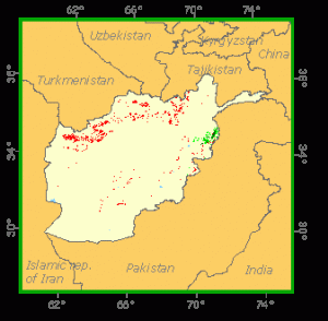
Afghanistan is sparsely forested. The most important areas of forest are east of Kabul in the western Hindu Kush and along the Pakistani border. Forests are primarily submontane or montane and comprise a mix of mainly Pinus, Quercus and Cedrus species. Areas of riverine forest occur along watercourses in the west of the country and in valleys such as Bamyian and Faizabad. Forests, which historically covered a significant proportion of the country, have largely been superseded by steppe land. Woodlands occur in montane areas and as patches of scrub. During the Afghan civil war forests have been heavily cut and timber smuggling is a significant problem for Afghanistan. The country has one national park, Band-e Amir, and 5 other protected areas, though none of these provide forest protection as a primary goal.
Geographic Description
The Islamic State of Afghanistan is bounded by Turkmenistan, Uzbekistan, and Tajikistan on the north, China on the far north-east, Pakistan on the east and south, and Iran on the west. It covers an area of 652 090 km2. Its maximum length from east to west is about 1 200 km; from north to south about 1 000 km. The north-western, western, and southern border areas are primarily deserts. The centre of the country is dominated by the massive, glacier-covered peaks of the Hindu Kush, a western extension of the Himalayas. The Amu Darya and Panj Rivers form the northern border.
Much of the land is mountainous, with about one-half over 2 000 m in elevation, raising to a maximum elevation of 7 485 m. The Hindu Kush range extends across the country in a north-east to south-west direction and other mountain ranges radiate from it. Some of these include the Pamirs in the upper north-east, the Badakhshân Ranges in the north-east, the Paropamisus Range in the north, and the Safed Koh Range, which forms part of the frontier between Afghanistan and Pakistan. Lowlands are found in the south and west.
Afghanistan has clearly defined seasons with hot summers and cold winters. Temperatures vary greatly during the day, and can range from freezing conditions at dawn to the upper 30°s C by afternoon. Most of the precipitation falls between the months of October and April, but in the mountains and a few of the eastern valleys, monsoons may bring moisture in the summer. The average annual precipitation ranges from 50 mm in desert areas to over 1 000 mm in the mountains. Temperatures in the northern plains average about 3° C in January and approximately 32° C in July. The average annual precipitation in the region totals about 180 mm. The central highlands have an average temperature of about -4° C in January and about 24° C in July. The region receives about 380 mm of precipitation yearly. Temperatures in the lowlands average about 2° C in January and about 29° C in July.
Forest Industry
Resources Forest cover Vegetation
Natural Woody Vegetation Description
Introduction
Forests once covered a large part of Afghanistan. Due to human impact, parts of these forests have been removed. The forests and timberlands of Afghanistan are divided into:
The timber forests: These are normally situated between elevations of 1 500 and 3 600 m above sea level in the southeastern and eastern parts of the country, in the Provinces of Paktia, Nangarhar, Kunar, Laghman, and Parwan.
Pistachio forests: These are mainly located in the provinces of Heart, Bedghis, Fariab, Balkh, Samangan, Juzjan and Kunduz.
Shrubby vegetation: This consists mainly of xerophytic bushes, widely distributed to the west of Kabul.
Closed Forests
Broadleaved
Between 1 200 and 2 000 m altitude the Himalayan deciduous forest of oak (Quercus baloot) dominates. Trees grow up to 15 m high with a rich undergrowth. Oak trees are accompanied by several other tree species including almonds (Amygdalis kuramica) and pistachios (Pistacia khinjuk). The Q. baloot forest in the Pansjir valley northeast of Kabul forms the western most extension of the Himalayan forest belt.
In very humid places with high summer rainfall Q. baloot is replaced by Q. dilatata. Between 2 400 m and 2 900 m altitude it is replaced by Q. semecarpifolia associated with Juglans regia, Acer turkestanicum and Pyrus pashia.
Coniferous
In the temperate coniferous forest belt in eastern Afghanistan, at 2 500 to 3 100 m altitude, Cedrus deodora forest is found. Depending on soil and humidity, these cedar trees may reach a height of up to 50 m and form a very dense forest. Large areas of these forests have been exploited and replaced by a stable Artemisia community.
In the humid areas of the upper forest belt, up to an altitude of 3 300 m, a Picea smithiana – Abies webbiana forest reaching 20 to 25 m in height is found. In the dry areas a forest dominated by Juniperus seravschanica up to 10 m high occurs. Mature stands are rare. The herbaceous ground cover, especially along the streams, is heavily overgrazed.
Mixed
In the temperate forest belt of eastern Afghanistan, at 2 200 to 2 500 m altitude, Pinus gerardiana woodland 5 to 12 m high with local stands of Betula spp. grows. A thorny Cotoneaster – Sophora – Rosa scrubland colonizes these areas after felling of the pine.
Open forests
Broadleaved
To the north of the Hindu Kush, on the extensive plains at altitudes of 600 to 1 600 m, woodlands of Pistacia vera associated with Amygdalis bucharica occur. In the northeast Cercis griffithii is characteristic.
Mixed
In the upper part of the forest belt on the northern slopes of the Hindu Kush an open mixed woodland dominated by Juniperus excelsa and Pistacia vera is found. The forest is heavily exploited for charcoal production.
Other wooded land
Shrubs
The active sand dune areas and dunes in the desert of northern and southern Afghanistan (Registan) are fixed by an open vegetation. The main plants are Haloxylon persicum, Calligonum spp. and perennial Aristida spp. In lower-lying saline areas, Chenopodiaceae are dominant and in the salt plains of Seistan the very open vegetation is characterized by Haloxylon salicornicum, Salsola spp., Ephedra scoparia and Tamarix spp.
The low-lying steppes in the west and south are dominated by an open vegetation of Artemisia herba-alba and other Artermisia species, Zygophyllum spp., Acantholimon spp., Acanthophyllum spp., Atriplex spp., Alhagi camelorum and Cousinia spp. Along the dry riverbeds there are thorny belts of Stocksia brahuica, Amygdalis communis and Convolvulus spinosus. The floral composition is very variable and depends on humidity, length of winter, sand composition, wind force and grazing pressure. More humid places have denser vegetation with a richer species composition. In areas west of Heart province with cold winters, Artemisia spp. and Ferula spp. dominate along with geophytes such asIris songarica and Allium spp.
The semi-desert areas of the higher mountains around Bamyan are dominated by Salsola spp. High level steppes benefit from higher precipitation as well as lower evaporation. Overgrazing favours the less palatable Artemisia scrubs and annuals at the cost of the palatable perennials.
In the regularly flooded areas taiga vegetation is found. It is dominated by Tamarix spp., willows (Salix spp.) and reeds (Phragmites australis). Depending on the frequency of inundation, species such as Populus, Myricaria, Berberis, Crataegus and Hippophaea grow. Herbaceous plants are well represented. The original forests of the major river valleys have been replaced by irrigated croplands.
Along the riverbeds in well-drained areas with deep soils, many wild fruit trees occur. They include apple (Pomus spp.) and almond (Amygdalis spp.). Forest trees including Fraxinus spp., Acer spp. and Plantanus spp. also occur.
Amygdalis scrub lands grow between the steppes of the south and west and the woodlands of the Hindu Kush. An Amygdalis brahuica community is found between 1 000 and 2 000 m altitude in the dry valleys of the east.
On the higher slopes of the Hindu Kush open Pistacia woodlands are replaced by the Amygdalis community. These woodlands are heavily exploited. The southern slopes of the Hindu Kush are characterized by 4 to 6 m high Pistacia atlantica and are rich in herb species such as Gagea, Anemone and Allgum. Pistacia khinjuk and Cercis griffithii are found in the Kabul Logar valley. Above this zone, between 2 000 and 3 000 m altitude and in areas with annual precipitation of more than 400 mm, a 2.5 to 6 m high Amygdalis community is dominant. Many scrub species and geophytes such as Eremurus spp., Corydalis spp., Gagea spp., Tulipa spp. and Allium spp. also occur.
Perennial grasses, thorny evergreen shrubs and small trees predominate in the lower Kabul valley under hot summers and moderate winters. Heavy grazing and fuelwood collection have reduced the shrubs and led to an increase of annuals. A Zizyphus nummularia community occupies the lower regions (up to 750 m altitude). At higher levels it is replaced with a Salvia-Pistacia community. In the dry higher valleys Acacia modesta invades the vegetation. At 700 to 1 300 m altitude there is sometimes a Reptonia buxifolia and Olea ferruginea woodland up to 25 m in height, which is heavily utilized for fodder.
Above 3 300 m in the east, in areas with summer rains, dense 0.5 to 1 m tall subalpine vegetation of Juniperus squamata, Rosa spp., Ribes spp. and Rhododendron spp. develops. On deep soils, Salix spp. may dominate this community.
In the Hindu Kush, a subalpine Juniperus nana community with many thorny dwarf shrubs occurs. Between 3 600 and 4 000 m, in the central and northern Hindu Kush, there is a cushion scrubland of Acantholimon spp., Artemisia spp., Astragalus spp., Cousinia spp., Ephedra spp. and Onobrychis spp. as sub-dominants. At higher altitudes open alpine vegetation, poor in species, occurs. The higher peaks and ridges are dominated by alpine heaths and low frost-resistant herbaceous and woody vegetation.
References
Tandon, J. C. 1988. Forests and forestry in Afghanistan. Sector review .FAO project AFG/86/011. Kabul. Pp71.