Forest Resource
Overview
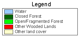
Angola is moderately forested with around 18 percent forest cover and an additional 43 percent of other wooded land. Angola´s closed forests are predominantly lowland, semi-deciduous forests and occur mainly in the north of the country, particularly in the Mayombe forest in the enclave of Cabinda. Common commercial species include Chlorophora excelsa, Terminalia superba and Albizia spp.. Large areas of mangrove forests, and areas of semi-deciduous high forest, occur around Luanda. To the south and west, the forests give way to open savannah forest with both miombo (Brachystegia-Isoberlinia-Julbernardia associations) and mopane (Calospermum mopane) woodlands occurring according to the relative dryness of terrain. The southern coast of the country stretches into the Namibian Desert. Angola has established a significant area of plantation forests based on Eucalyptus spp.. The country has more than a dozen protected areas encompassing around 3 percent of the country´s forests.
Forest Types
Geographic Description
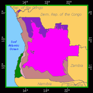
The Republic of Angola covers an area of 1 246 700 km2, lying between latitudes 4° 22´ and 18° 02´ S and longitudes 11° 41´ and 24° 05´ E. With the exception of Cabinda, the country forms a square with sides about 1 250 km long, touching the Atlantic Ocean on the west (giving a total coastline of about 1 600 km) and bordering the Democratic Republic of the Congo on the north and north-east, Zambia on the east, and Namibia on the south. The Cabinda enclave covers 7 200 km2 north of the mouth of the Congo (or Zaïre) River.
The following four major geographic regions can be distinguished:
- The coastal plain, also found in the west of Cabinda, with a width varying from 25 km in the south to 100 to 200 km in the north.
- The central highlands with an average height between 1 000 and 1 300 m, covering almost two-thirds of the country. They are dominated by several mountain chains forming a crescent lying in a roughly south-west to north-east direction and including the Serra Moco, the highest point in the country (2 620 m). This region is one of the main sources of water for southern Africa.
- The northern foothills of the highlands toward the Congo basin, north of latitude 10° S, where most of the country´s closed forests are found, the remainder being located in eastern Cabinda.
- The eastern and southern foothills of the highlands towards the central depression of southern Africa and the Kalahari basin.
Most of Angola´s rivers rise in the central mountains and drain either to the Atlantic Ocean or the Congo River, but those in the south-east drain to the Okavango swamps in Botswana.
The climate is generally tropical in type, tempered by sea and altitude, but it does vary considerably depending on latitude, as well as the effects of the cold Benguela current along the coast. Rainfall reaches 1 800 mm and more in inland Cabinda and decreases rapidly along the coast, dropping to under 100 mm in the south (Moçâmedes province). It is over 1 500 mm in the highest parts of the highlands, especially in Huambo, Lunda and Uige provinces. A dry season lasts from September to April. Temperatures in the coastal plain region average about 21 °C in January and about 16 °C in June. The central plateau is cooler.
Forest Cover Vegetation
Closed Forests
Broadleaved
Angola´s closed forests are concentrated in two major masses, one in the Dembos region, between latitudes 6° 30´ and 9° 30´ S and longitudes 14° and 15° 30´ E, in Uige and particularly Cuanza Norte provinces, the other in the northern half of the Cabinda enclave (or Angolan Mayombe). There are also numerous scattered gallery forests, mainly in the northern half of the country.
These stands are generally low- to medium-altitude semi-deciduous moist closed forests with several storeys reaching as much as 60 m in height. The Dembos forest, situated between 400 and 700 m, has been seriously degraded by coffee plantations that retain some forest cover, “consisting of a small number of species chosen for their capacity to provide shade” (“secondary coffee forest” with Celtis, Albizia, Morus, Ficus, etc., in Grandvaux Barbosa´s classification). A number of prized wood-producing species have been extracted, for example trade iroko (Chlorophora excelsa), Pteleopsis diptera, trade white mahogany (Khaya anthotheca), trade padouk (Pterocarpus tinctorius), Entandrophragma spp., Diospyros mespiliformis and Albizia spp.
The semi-deciduous closed forest of Mayombe is similar to that of neighbouring countries (the Democratic Republic of the Congo and the Republic of the Congo). The most exploited timber species have been trade tola (Gossweilerodendron balsamiferum), trade limba (Terminalia superba), trade tchitola (Oxystigma oxyphyllum), Entandrophragma spp. and trade iroko (Chlorophora excelsa).
Vestiges of mountain forest situated in ravines and depressions along watercourses cover very small areas in the highlands of Benguela and Huila provinces (“montane dry conifer forest”). Muxito pine (Podocarpus milanjianus), the only Angolan conifer, is predominant here, accompanied by broadleaved species such as Parinari spp., Faurea saligna, Chrysophyllum spp. and Syzygium huillense.
Gallery or riparian forests cover a fairly large area. North of the Cuanza basin (north of latitude 9° S) as well as further inland, they are distinguished by trade kapok (Ceiba pentandra) and Lonchocarpus erinaceus, associated with introduced species such as mango (Mangifera indica), Elaeis guineensis and Spondia mombin. Semi-deciduous and even evergreen forest species such as trade ilomba (Pycnanthus angolensis, trade bilinga (Nauclea diderrichii), iroko and white mahogany are found here because of favourable edaphic conditions. Moving southward, these forests steadily become smaller and poorer in species until they are reduced to lines of small trees or shrubs, in particular Syzygium. South of latitude 15° S they cannot be picked out on satellite images, if indeed they still exist.
Grandvaux Barbosa distinguishes evergreen dry closed forests in the upper Zambezi region (east of Moxico province), with a rainfall of 1 100 to 1 200 mm, dominated by Cryptosepalum exfoliatum and covering over 150 000 ha in the neighbourhood of Macondo. Although the dominant storey is sometimes sparse as a result of repeated fires, these forests have been classified as closed broadleaved forests, as in Zambia, because of the almost total absence of a grassy layer.
Mangroves are found at the mouths of all the large rivers, becoming more shrub-like further south and disappearing completely south of Benguela. Rhizophora mangle is the main species, followed by R. racemosa, Avicennia nitida, Chrysobalanus ellipticus, Annona palustris, Pandanus spp., Erythroxylon emarginatum and Conocarpus erectus.
Swamp forests or periodically flooded forests cover considerable areas, for example between the marshes and savannah near the Congo, on the edge of the Congo mangroves, or as small stands in swamps and on the edge of lakes at sea level. Mitragyna stipulosa, Homalium stipulaceum, Anthothesma aubryanum, Xylopia spp., Alstonia gilletii, Nauclea diderrichii, Symphonia globulifera, Uapaca guineensis, Raphia spp., etc., are the most common species. Most of these forests are found in Cabinda and Zaïre provinces in the far north of the coastal zone.
Bamboo Palms
Palms (Hyphaena spp.) are very common near the coast, sometimes forming almost pure stands, and an introduced species, Anacardium occidentale, is also spreading naturally.
Borassus palm (Borassus aethiopium) stands, which are found especially in the north of Uige, Malanje and Lunda provinces, are a type of tree savannah.
Forest Industry
Open forests
Broadleaved
Coastal forests stretch from Cabinda roughly to latitude 13° S in the coastal region. Baobab (Adansonia digitata) is found in association with Colophospermum mopane, Spirostachys africana, various Leguminosae (Acacia spp., Burkea and Faidherbia albida), Combretaceae (Terminalia and Combretum) and Rubiaceae (Adina) between altitudes of 500 and 1 400 m. Colophospermum mopane tends to dominate on poorly drained soils, forming almost pure stands. From 1 400 to about 2 000 m various species of Brachystegia dominate, while the previous species disappear. Coastal stands are very degraded as a result of excessive cutting for firewood and wood charcoal by local inhabitants.
Open forests, essentially of the miombo type, stretch over almost all the inland highlands of Malanje, Benguela and Huila. They are typically dominated by species of the Brachystegia, Isoberlinia and Julbernardia genera, notably B. spiciformis and J. paniculata. Baikiea plurijuga and Ricinodendron rautanenii (Pereira Coelho, 1966) form varying closed and pure stands that are of commercial value respectively for industrial wood and oil products. Other common arborescent genera are Berlinia, Daniellia, Erythrophleum, Marquesia, Parinari, Pterocarpus and Uapaca.
Tree savannah often represents a degraded form of closed or open forest resulting from large very large trees left when land is cleared for farming. The most common tree species are listed in the previous paragraphs.
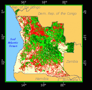
Forest Map
Other wooded land
Shrubs
Various types of thicket are found in different parts of Angola, the largest concentrations being those located as follows:
- In the chanas da borracha in the north-east of the country, in the north of Lunda province, made up partly of shrubby thickets;
- In the high areas of the central highlands (between 1 900 and 2 200 m) in the form of stunted miombo;
- In the coastal zone, between latitudes 9° and 12° S in the form of xerophilous thickets, with Euphorbia conspicua, Strychnos henningsii, Combretum camporum, Acacia welwitschii, etc.;
- In Malanje province (Baixa de Cassange region), in the form of shrub savannah, with Sterculia quinqueloba, Terminalia sericea, Erythrophleum africanum, Hymenocardia acida, Bauhinia spp., etc.
References
Grandvaux Barbosa, L.A. (1970). Carta Fitogeográfica de Angola. Luanda.
Pereira Coelho, H. V. (1966). Manchas florestais de Ricinodendron rautnenii Shinz (mongongo) no distrito do Cuando Cubango (estudo previo). In: Agronomia Angolana No. 24, Luanda.
Romero Monteiro, R. F. (1961). Panorama forestier de l’Angola. In: Bois et Forêts des Tropiques No. 75, Nogent-sur-Marne, France.
Romero Monteiro, R. F. (1970). Estudo da flora e da vegetação das florestas abertas do planalto do Bié. Luanda