Forest Resource
Overview
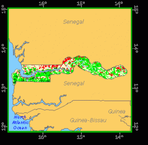
The Gambia is moderately forested with around 9 percent forest cover and an additional 19 percent of other wooded land. The country’s closed forests are mainly riparian and comprise mangrove species in the estuarine section of the Gambia River (up to 150 km inland) and limited sections of gallery forests in the freshwater section. Common mangrove species are Rhizophora racemosa and Avicenna africana, while the gallery forests include commercial species such as Khaya senegalensis and Chlorophora regia. Most woody vegetation is away from the river, in open savannah. Located in the southern Sahel, Gambia’s savannah is essentially of Sudanian-type. Characteristic species include Parkia biglobosa, Daniellia oliveri and Acacia species. Gambia has a modest network of protected areas, including 3 national parks. Almost two percent of the country’s land area is in protected areas.
Forest Types
Geographic Description
The Republic of the Gambia, located on the western coast of Africa, extends inland along the river of same name. It runs in an east-west direction at an average latitude 13′ 30 N, cutting across Senegal for over 330 km, but is only about 50 km wide at its widest point. The country covers a total area of 11 295 km2. It is very level with an altitude not exceeding 50 m.
The river and seacoast are lined with mangrove swamps. Further inland, the land is seasonally flooded by the river. Sandy plateaus extend along the sides of the river to the borders with Senegal.
Average annual rainfall ranges between 900 and 1 100 mm except in the south-western part (western division and Banjul and Kambo districts) where it can reach 1 400 mm in some localities. There is one single intense wet season of five months (June-October) juxtaposed with a seven-month hot, dry season.
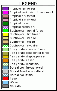
Ecological Zones
Forest Industry
Forest cover Vegetation
Closed Forests
Broadleaved
The only closed forests present in The Gambia correspond to special edaphic conditions.
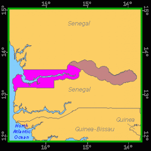
The mangroves penetrate deep along the Gambia River and its tributaries. The typical succession is described in Dunsmore (1976) as follows: “each saline water course is characteristically bordered up to the limits of daily tidal flooding by a gallery of tall Rhizophora racemosa. Inside the gallery up to the mean limits of inundation by spring tides are found woodlands of Avicennia africana. Rhizophora harrisonii and R. mangle occur at the boundary between the R. racemosa and A. africana stands”. R. racemosa appears to be the pioneer species and being replaced later on by A. africana until the soil raised becomes too arid to support vegetation during the dry season and constitutes salty barren flats (called “tanns” in Senegal). Both types of mangroves are used by villagers for fencing poles, in house construction and for fuelwood either for local consumption or for sale in Banjul.
Gallery forests-“riparian woodland” according to Dunsmore (1976)-are found along the streams above the limit of tidal waters and contain most of the useful commercial timber species, particularly mahogany (Khaya senegalensis), Chlorophora regia (trade name: iroko) and other tree species such as Parinari excelsa and Leguminosae like Detarium senegalense, Dialum guineense and Erythropheum guineense.
Bamboo/Palms
Most common palm species are Elaeis guineensis and Borassus aethiopium (rhun palm).
Open forests
Broadleaved
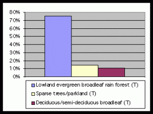
Practically all the woody vegetation of the country is a mixture or more or less degraded mixed forest-grassland formations of varying heights and densities. These can be characterised as:
- “Parkland” or “woodland savanna” in frequently farmed areas with Parkia biglobosa, Daniellia oliveri (in the west), Bombax buonopusense, and without shrubs;
- “Disturbed woodland with shrub understorey” with Combretaceae (Combretum micranthum, Guiera senegalensis, Anogeissus leiocarpus, and Terminalia spp.) and Leguminosae species (Cordyla pinnata, Cassia siberiana, Swartzia madagascariensis, Prosopis africana and Acacia spp.) and a bamboo (Oxytenanthera abyssinica);
- “Mitragyna-scattered Acacia tree savanna”.
Other wooded land
Shrubs
Formations with shrubs as the main woody elements are termed differently by various authors. Dunsmore (1976) distinguishes shrub communities in drainage depressions and alluvial areas with Mitragyna inermis and Acacia seyal and coastal vegetation with Parinari macrophylla.
References
Dunsmore, J. R. et al (1976). The agricultural development of The Gambia: An agricultural, environmental and socioeconomic analysis. Land Resources Study 22, Land Resources Division, Surbiton (U.K.).
Openshaw, K. (1973). The Gambia: A wood consumption survey and timber trend study, 1973-2000. Report to the ODA/LRD Gambia Land Resources Development Project. Midlothian (U.K.).
Forest Map