Forest Resource
Overview
Jamaica has relatively modest forest cover with around 15 percent of the total land area under forest. Originally, Jamaica was almost entirely covered with forest, however, virgin natural forest remains only in less accessible areas. The majority of remnant rainforest is tropical montane forest, with mountain mist forests, on the upper slopes of the Blue Mountains, the least disturbed. The mist forest canopy is predominantly Podocarpus spp.. The lower mountain and sclerophyll forests have been largely cleared for agriculture. Lowland vegetation tends to be dominated by scrubforest “ruinate”, with emergent trees being Cedrela spp. and Terminalia spp.. Jamaica has a modest area of plantation forest, based on Pinus caribaea. Jamaica has two National Parks, with the Blue Mountain/John Crow Mountain National Park, being the more important from a forest perspective.
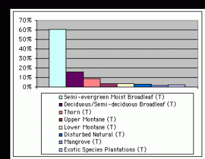
Forest Types
Geographic Description
Jamaica, one of the Greater Antilles, is located in the Caribbean Sea. It covers a total area of 10 990 km2. It is an island with more than half the land over 20 degrees of slope. The Blue Mountains dominate the eastern end, rising sharply from sea level to their highest point at 2 256 m on Blue Mountain Peak. The Blue Mountains are mostly made up of metamorphic rocks with long steep slopes and soils liable to rapid surface erosion.
In contrast, the major part of the central and western area of the island is made up of a hard white limestone of rugged karst topography, with an altitude generally below 1 000 meters. The Cockpit country in the west (named for the many deep depressions) has very broken karst topography with elevations generally over 1 200 m. A major feature in the central area is an elevated area of schist. Again, the slopes are very steep with soils liable to rapid surface erosion. Plains of alluvium and raised coral reefs, with good access, occur in various places along the coast.
The island has a number of excellent natural harbors, including those at Kingston, Saint Ann’s Bay, Montego Bay, and Port Maria.
Jamaica falls within the “tropical region” of the Holdridge Life Zone classification. All land above 380 m is classified as being in the pre-mountain elevation belt of the tropical region. The hot, humid climate is moderated by ocean winds.
Temperatures average 24° C in the winter and 27° C in the summer, although temperatures in the mountains can drop to 4° C. There are two rainy seasons, May through June and September through November. The rainiest months are May and October. The yearly rainfall varies from about 760 mm along the coast to about 5 100 mm in the mountains. The country is subject to hurricanes in late summer and early autumn.
Forest Industry
Resources Forest cover Vegetation
Natural Woody Vegetation Description
Introduction
The terminology of Asprey and Robbins (1953) is used below in the presentation of woody vegetation types of Jamaica. Because of the secondary character of most of the vegetation types and of the rugged topography, the distinction between closed and open formations and between forest and other wooded land is somewhat artificial.
Closed Forests
Broadleaved
Wet limestone forests
This community develops on limestone rock in inland areas where the rainfall is over 1 900 mm and up to 3 800 mm, mainly between 300 and 750 m elevation. The largest area occurs in the Cockpit country, so called because of the circular depressions (dolinas) caused by karst phenomena. Other areas are located at Mt. Diablo (1 080 m) and Dolphin Head (540 m). Burning and cultivation have affected many areas. The forest is made up of two types-that on the bare limestone rock and that on the valley floor. The canopy of the forest is more or less uniform and closed, though never dense, with a height of 15 to 18 m, except in the “cockpits” where emergent trees of Terminalia latifolia and Cedrela odorata are 25 to 30 m high. A dense sub-storey of small trees, 13 m high on average, may be distinguished. Undergrowth is generally lacking. Climbers, Bromeliaceae, Piperaceae and tree ferns are present. The trees are generally evergreen. The true climax in the small deep valleys is the Terminalia–Cedrela association. Other large trees that are common are Santa Maria (Calophyllum jacquinii), Pithecellobium alexandri, breadnut (Brosimum alicastrum), sweetwoods (Nectandrasp.) and bulletwoods (Dipholis sp.).
Dry limestone scrub forests
Along the southern coast of Jamaica there are a series of rocky limestone hills and ranges, mostly under 250 m elevation, with an annual rainfall of less than 1 000 mm distributed in two rainy seasons. Dry limestone scrub forest is a sparse cover of low forest and tall scrub growing on bare limestone rock. Species composition may change rapidly from area to area, depending on local conditions. Red birch (Bursera simaruba) is ubiquitous as a scattered emergent deciduous tree. It has been suggested that its prevalence is due to fire resistance and selective cutting, as the wood is regarded as useless for lumber. A host of small xerophytic trees and shrubs make up the mass of the vegetation. In the undisturbed parts, emergent trees other than red birch are Swietenia mahogany, Spondias mombin and Plumiera sp., all deciduous. Many other species lose a part of their leaves in the dry season.
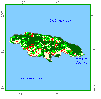
Forest Map
Lower mountain rain forests
On the Blue Mountains, much of the original forest occupy the more inaccessible parts. The main canopy is 20 to 22 m high, apart from a few scattered emergents of species such as Psidium montanum, Symphonia globulifera and Ficus suffocans, reaching up to 40 m. The canopy is often dense where there is a single dominant, such as Santa Maria, but more open in the mixed forest. The lower tree layer is similarly variable in density and between 9 to 15 m tall, with well-defined stratification. The shrub layer is usually sparse, and represented by spindly shrubs of Rubiaceae and Melastomataceae, together with Eugenia, Piper and Heliconia sp. Lianas are not abundant, and epiphytes (bromeliads) confined to the higher tree branches.
Mountain sclerophyll forests
At about 750 m on the leeward slopes of the Blue Mountain Range the vegetation changes quite suddenly to a sclerophyll zone that continues up to 1 200 m. At lower elevations it consists of a low open shrubby community under the periodic influence of shifting cultivation. Above this is a less disturbed thicket of small trees and shrubs that extends up to the mist forest. Two very characteristic shrubs in the lower zone are Baccharis scoparia (mountain broom) and Dodonaea viscosa. In the higher zone many of the species belong to the Ericaceae and Myrtaceae. Probably the lower sclerophyll belt is a second growth community that, if left undisturbed, might eventually lead to sclerophyllous thicket or, on the wetter slopes, to lower mountain forest. As a result of repeated burning there are large patches with an almost pure ground cover of grass (Melinis minutiflora) or fern (Gleichenia pectinata).
Mountain mist forest
This is one of the few remnants of original vegetation, and occurs on the upper slopes of the Blue Mountains. The forest is low-canopied. Mist, which cuts down the light and increases humidity, is a far more important factor than rainfall. Emergent trees are few and the canopy is 12 to 14 m high, uneven and somewhat open. A sub-canopy of varying density can be recognised at about 10 m. The shrub layer at 3 m is scattered. Dominant trees of the canopy are Podocarpus urbanii, Cyrilla racemiflora and Alchornea latifolia. Tree ferns are frequent while palms are absent.
Mangrove woodland
Four habitats can be distinguished: silt, sand, peat and coral reefs. The four American species, red mangrove (Rhizopora mangle), Laguncularia racemosa, Avicennia nitida and Conocarpus erecta, are all represented.
Open forests
Broadleaved
Elfin woodland
Elfin woodland is found on the exposed summits and northern ridges of theBlue Mountains, at 1 500 m and over. It is open woodland of gnarled and twistedtrees, often short, windblown and laden with mosses, lichens, fern andepiphytes. The canopy is reduced to 6 m and is uneven, due to the brokentopography. Dominants are Clusia clarendonensis and Clethra occidentalis. There is but a single woody stratum.
Other wooded land
Shrubs
Arid coastal dry limestone scrub forest
For a distance of over 30 km along the south coast from Morant Bay to Portland Ridge there is a rim of this vegetation in an area with total rainfall below 800 mm/year and a 6- to 10-month dry season. The xerophytic vegetation is tolerant of salt spray and sweeping winds. It is littoral woodland on coastal limestone made up of hard-leaved dry limestone shrubs together with cacti, halophytes and salt-resistant trees. Dildo (Cercus sp.) forms stems up to 7 m high.
Thorn scrub
There are extensive low-lying coastal plains along the dry southern coast. The plant communities are all modified secondary types. Among them exists a thorn scrub, usually open or sparse. Prosopis juliflora makes up three-quarters of the trees, the remainder being otherLeguminosae.
A common form of secondary community, called “ruinate,” is a thorn thicket, or, under moderate cutting and grazing, a thorn savanna. After invasion of pioneer weeds on denuded land, secondary invaders come in and, finally, shrub and tree seedlings. Such ruinate may eventually become a thorn thicket or thorn savanna dominated by Acacia lutea. Most of the ruinate forests are located in the white limestone mountains of central and western Jamaica.
References
Asprey, G. F. and R. G. Robbins (1953). The vegetation of Jamaica. Ecological Monographs, Vol. 23. Durham, N. C. (U. S. A.)