Forest Resource
Overview
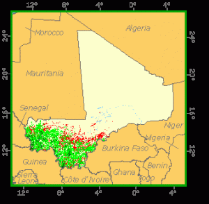
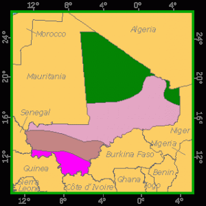
Mali is lightly forested with around 9 percent forest cover and an additional 14 percent of other wooded land. Mali’s vegetation types extend from Sudanian-Guinean in the south, through Sudanian and Sahelian zones, to Saharan desert occupying most of the northern half of the country. An extended drought and desertification are major problems in Mali. Closed forests are almost exclusively patches of gallery forest in riparian areas and comprise a mix of mainly semi-deciduous forest and savannah species including Isoberlinia doka, Afzelia africana and Khaya senegalensis. Mali’s wooded areas are dominated by savannah, with Isoberlinia doka characterising the Guinean-type savannah, Parkia biglobosa representative of Sudanian-type, and Acacia spp. scrub representative of Sahelian vegetation. Mali has established modest areas of plantation forest with the most common species being Eucalyptus spp. and Gmelina arborea. Mali has extensive land areas in parks and reserves. The most important, from a forest perspective, is probably Boucle du Baoule National Park.
Forest Types

eographic Description
The Republic of Mali, located in north-western Africa, is bounded on the north-east by Algeria, on the east by Niger, on the south by Burkina Faso, Côte d’Ivoire, and Guinea, and on the west by Senegal and Mauritania. Its area is 1 240 192 km2. Situated between latitudes 10° and 24° N, it is a landlocked country with frontiers not corresponding to any natural feature. Access to the sea is through Dakar to the west, by the Océan-Niger railway; through Abidjan to the south, linked by road to the capital; through Conakry to the south-east, by the Conakry-Niger railway; and by tracks running from Kankan, the Guinean rail-head, to Bamako and western Mali.
The topography is mostly low plateaux and basins with occasional rocky hills. The plateaux never exceed 300 or 400 m. Sloping both northward toward the Niger basin and southward, they cover large areas and have lateritic soils.
The only irregularities are the gorges of the Niger valley and the striking precipices resulting from erosion (the Bandiagara cliffs). Adrar des Iforas in the north-east is a crystalline massif sculpted by desert erosion, while in the south-west the Guinean Fouta Djallon massif extends into Mali in the form of a plateau sloping north-eastwards.
The Niger flows sluggishly through a huge depression with very little gradient, spreading out in the Macina, an enormous network of lakes and swamps between Mopoti and Tombouctou. The northern third of the country lies within the Sahara. In the west is a part of the Sahel, a semiarid transitional zone between areas of savannah and the Sahara desert. Rolling grasslands cover the south.
The climate is of the warm tropical type with average temperatures ranging from about 24° to 32° C and can be subdivided as follows:
- A Sudano-Guinean zone in the south and centre of the country where annual rainfall is over 1 300 mm, with seven rainy months;
- A Sudanian zone a little further north where rainfall ranges from 700 to 1 300 mm;
- A Sahelian zone marking the transition between the savannah and desert zones with rainfall between 200 and 700 mm;
- A Saharan zone in the north of the country where the sparse rainfall is under 200 mm per year. Here, temperatures often exceed 38 °C and may rise to more than 43 °C during the day. At night, however, temperatures may reach as low as 4 °C.
Ecological Zones
Forest Industry
Forest cover Vegetation
The vegetation corresponds to climatic zones:
- Guinean savannah – either tree or bush – in the south, covering about 6% of the country. There are also areas of dry closed forest and gallery forest.
- Sudanian savannah, covering 27% of the country. It comprises savannah park (750 to 1 200 mm rainfall) and grass savannah (500 to 750 mm rainfall), and is the country’s farming zone.
- Sahelian shrub steppe, covering 16% of the country, a livestock-raising zone.
- Subdesert tropical steppe with rainfall of 50 to 200 mm, covering 21% of the country.
- Desert, covering 30% of the country.
Closed Forests Broadleaved
There are gallery or riparian forests with almost closed cover in the Sudano-Guinean zone. Remnants of closed dry semi-deciduous forest are found within the tree savannah in the same zone, with tree species such as Khaya senegalensis, Isoberlinia doka, Afzelia africana, Pterocarpus erinaceus, Daniellia oliveri, Cordyla pinnata, Burkea africana, Prosopis africana, Butyrospermum parkii, Parkia biglobosa, Anogeissus leiocarpus, Lophira lanceolata, Bombax costatum, Carapa procera, Erythrophleum guineense, Ekebergia senegalensis and Pseudocedrela kotschyi.
Open forests Broadleaved
These are basically the open forest, savannah woodland and tree savannah of the Sudano-Guinean and Sudano-Sahelian zones, comprising:
- Guinean savannah woodland of Isoberlinia doka, Uapaca somon, Erythrophleum guineense and Lophira alata;
- Savannah park, which is typical Sudanian savannah marked by the presence of Butyrospermum parkii, Parkia biglobosa, Acacia faidherbia, Tamarindus indica, Khaya senegalensis, Terminalia spp., Adansonia digitata and Bombax buonopozense;
- Tree and bush savannah north of the savannah park and south of the sub-Sahelian zone. Woody species occurring here are Combretaceae, Guiera senegalensis, Ziziphus and Acacia spp. There are stands of Acacia sieberiana and borassus palm (Borassus aethiopium) in periodically flooded areas.
Other wooded land Shrubs
These are the tree and shrub steppes of the Sahelian zone, with Acacia tortilis, A. stenocarpa, A. verek, A. arabica, Ziziphus jujuba, Calotropis procera and Hyphaene thebaica as typical trees and shrubs
Forest Map