Forest Resource
Overview
Nepal has around 35 percent forest cover, although at least a quarter of the forest area is heavily degraded. Although most of Nepal lies within the sub-tropical monsoon climatic region, the wide range of topographic conditions allow for a wide variety of forest types. The distribution of natural forests generally follows altitudinal zones. The most common, below 1000 metres, are tropical sal forests, predominantly of Shorea robusta. Sub-tropical forests occur between 1,000-2,000 metres, and may be coniferous or broadleaved. The principal coniferous species is chir pine (Pinus roxburghii). The broadleaved forest is a mix of mainly chestnuts, alders and chilaune (Schima wallichii). Temperate forests, between 2,000-3,000 metres, include a mix of oak, pine and rhododendron. Sub-alpine forests are found from around 3,000 metres up to 4,200 metres with a mix of firs, beech, rhododendron and juniper. Nepal has a modest area of plantation forest. Almost 15 percent of the country´s land area is in National parks, wildlife reserves or conservation areas.
Forest Types
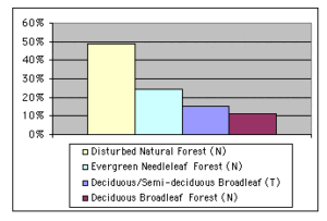
+27,911 ac Semi-Evergreen Moist Broadleaf (T)
Geographic Description
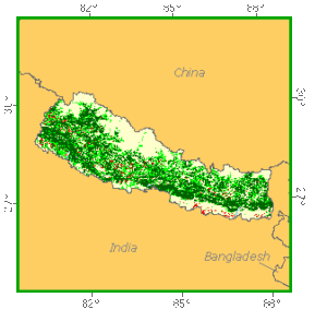
The Kingdom of Nepal covers an area of 147 180 km2 between latitudes 26° 20´ and 30° 10´ N and longitudes 80° 15´ and 88° 15´ E. Almost rectangular in shape, it extends over 850 km in length from east to west and 180 km in width from north to south.
The country is completely landlocked, surrounded by India on three sides, except on the north, where it borders China. The altitude varies from less than 300 m to that of the world´s highest mountain, Mount Everest, at 8 850 m. The country can be divided into three roughly parallel strips, each running east/west:
- The Terai is the southernmost strip, about 25 km wide, covering almost 17 percent of the total area. An extension of the Gangetic plain of northern India, it consists of generally level alluvial terrain blending into forested hills.
The strip runs across the entire length of the country at the foothills with varying width except at Dang and Chitwan where it is intercepted by the Someswar range. As a result, the Terai can be conveniently divided into eastern Terai, located in the east of Chitwan; mid-western Terai, streching between Chitwan and Dang-Deokhuri and far-western Terai, located in the west of Dang-Deokhuri.
The southern parts of the Terai are densely populated and most of the area is under agriculture. The northern part of the Terai, known as the Bhabher, has a lower population density. Lying adjacent to hills, its soils contain a higher proportion of boulders, gravel and sand that have been washed down from the hills and mountains during monsoon rains. Most of this area is forested and is noted for its fine forests of sal, Shorea robusta and its associates, known as Charkoshi-Jhari, “the 8 mile forests”;
- The Churia range, or Siwalik Hills, is the southernmost range of mountains of Nepal. It consists of several rugged folds, knife-like ridges and steep, sharply dissected slopes. The Churia range extends east to west at an average height of 760 m and merges into the Indian border through its extension at Dang, in the Dundwa range and at Chitwan, in the Someswar range. Large valleys, called duns, separate it from the Mahabharat range in the north.
Some of the larger inner Terai valleys are associated with the West Rapti and Babai rivers (Dang Deokhuri), Narayani and East Rapti rivers (Chitwan), Marinknola (Sindhuli-Makwanpur), Kamla (Sindhuli-Udayapur).
Although the inner Terai may be considered as part of the hills the vegetation of its valleys is similar to the Terai;
- The Mahabharat range, the areas between the Mahabharat and the Himalayas proper, the Himalayas and the inner Himalayan valleys are all mountainous. The Mahabharat range extends almost over the entire length of the country and most of it is below 3 300 m. The mountains therefore can be divided into the lower hills, reaching less than 1 300 m, and the upper hills or mountains, upper Mahabharat and great Himalayas. The terrain in this region is steep and rugged.
Climatically the entire country lies in the subtropical zone but a wide range of climatic conditions exist due to variation in elevation and topography. The Terai, being low in elevation, is hot and humid during the summer months. Temperatures at low elevations of 40° C are common during May and early June before the monsoon rains start. Average temperature decreases with elevation to a alpine or polar climate in the high mountains.
Most of the rainfall occurs from June to September. A few scattered rains occur during the winter months. Rainfall decreases from about 2 500 mm in the east to about 1 500 mm in the west. In the mountains, each hill area has its own microclimate depending on the elevation, cloud cover, steepness and direction of slope, etc.
Soils in Nepal are generally light and permeable because of the steep river gradients. The Bhabar zone consists of relatively coarse-textured soils, usually with less than 20 percent clay, often occurring as distinct sandy and gravelly fans at the foothills of the Siwaliks. These soils are very permeable, highly susceptible to erosion and the least fertile. In the southern Terai, the soils, though quite permeable, are more fertile thanks to the flat terrain and a higher water table. Most of the soils in the hill valleys are also relatively coarse textured. The hill slopes generally have more clay and silt.
The climate of the lower hills is conducive to the luxuriant growth of vegetation. In the upper hills, at subalpine elevations, from 2 700 to 4 000 m, winters are more severe and summers are cool. Above the tree line, 4 500 m approximately, alpine tundra with shrubs and lichens prevails. The area between 4 500 to 8 850 m, with its perpetual snow covered panorama, is about 35 km wide and accounts for 15 percent of the total land area
Forest Industry
Resources Forest cover Vegetation
Natural Woody Vegetation Description
Introduction
The entire country lies within the latitude of the subtropical region but variation in elevation, slope rainfall, temperature and, to a large extent, soil and drainage determines the location of major forest types. The vegetation varies from tropical moist forests to alpine scrub.
Closed Forests
Broadleaved
Sal forests, corresponding to the north Indian moist deciduous forest classification of Champion and Seth (1968), consist of forest stands where sal (Shorea robusta) is the predominant species (50 percent or more of the total basal area). The best stands grow on moist, well-drained, deep sandy loam soils with good subsoil drainage. On good sites, sal may reach 45 m, but it generally ranges between 25 and 40 m. It is considered a climax (climatic, edaphic or bioedaphic) formation and constitutes one of the most important forest types of Nepal, occurring in the northern Terai and valleys of the Churia hills. The type extends up to about 1 000 m in the Churia hills and in the mountains where it meets with the subtropical pine forests. Due to its resistance to fire, its coppicing ability and its adaptability to various soil and site conditions, it continues to retain its hold as a major species despite human influence. Sal is much used in Nepal, chiefly for construction. Common associates include asna (Terminalia tomentosa), jamun (Syzygium cuminii), banjhi (Anogeissus latifolia) and botdhainro (Lagerstroemia spp.). On higher reaches chir pine (Pinus roxburghii) is a common associate.
The Terai hardwood forests are mixed broadleaved stands growing in the Terai that may or may not contain sal. Other commercial timber species such as asna, jamun, botdhainro, karma or haldu (Adina cordifolia), gutel (Trewia nudiflora) and semal (Bombax ceiba) singly, or in combination, have a greater basal area than sal. They are closed forests of good height and development with a lower storey of smaller trees and shrubby undergrowth. Several subgroups in which one species achieves dominance are represented in this type. Asna stands are among the most important subtypes and corresponds to the edaphic variant of the “moist deciduous forests” type of Champion and Seth. These broadleaved forests occur throughout the Terai and valleys of the Churia hills where soil is heavy, moisture retentive or wet and on clayey patches. Asna is used as a construction timber. Banjhi stands form another important subtype and are almost pure in the western Terai where they occupy drier sites. These stands are generally well stocked, but the trees are of small size.
The khair-sissoo forests, corresponding to the general seral types of “Tropical dry deciduous forests” of Champion and Seth occur as the first coloniser on new sandy or gravelly alluvium along large rivers in the Terai. Sissoo (Dalbergia sissoo) generally predominates. Although this type occurs throughout the Terai, it occupies significant areas only in the Biratnagar, Banka, Bardia and Kanchanpur divisions. The stand canopy is light but usually fairly complete with 18- to 25-m-high trees. Khair (Acacia catechu) is usually present but often inconspicuous in the mixture. It may sometimes occur in pure stands. The older forests have a more or less definite understorey composed of young trees that will replace the khair-sissoo forests as succession takes place. Tamarix dioica, Calotropis procera and Holoptelea integrifolia are often present.
The lower slope mixed hardwoods occur in the eastern and central Himalayas in moist localities between 650 m and 1 500 m. In western Nepal the type is represented in moist hollows and depressions between 1 000 and 2 000 m elevation. These forests correspond to the type “northern montane subtropical forests” of Champion and Seth. They are characterised by the prevalence of chestnuts (Castanopsis sp.) and chilaune (Schima wallichii), which are almost always present, and also Quercus. Shorea robusta may be found but its presence is usually ascribable to edaphic peculiarities of the site. Pines are absent or confined to drier, sandy soils or well-drained ridges. The forests are of good height and stocking. The dominant species are mostly evergreens although some large, briefly deciduous trees occur, sometimes in pure consociations such as Betula. The tree canopy reaches a height of 20 to 35 m under normal conditions. A middle storey of evergreen trees can generally be found.
Oak forests of Nepal are found in the Mahabharat range, extending up into the subalpine region. These forests correspond to “northern montane wet temperate forests” and “Himalayan moist temperate forests” of Champion and Seth.
The wet forests are closed evergreen high forests of large girth but medium height, rarely exceeding 25 m. The type occurs from 1 800 to 3 000 m, mostly in eastern Nepal where rainfall is more than 2 000 mm. Deciduous species occur, particularly at the higher altitudes, but they form a relatively small proportion of the stand. Although the type is essentially a mixed one there is a marked tendency for a few species to predominate, such as oaks and Lauraceae species. Quercus lamellosa, Q. pachyphylla, Castanopsis tribuloides, Acer campbellii, Machilus spp. and Michelia spp. are the most common species.
The moist type consists of three common oaks providing a simple and convenient basis for subdivision into three elevation zones, each with its typical coniferous counterpart. Ban oak (Quercus incana) occupies the lowest belt of the temperate zone, particularly in the outer ranges and southern aspects. The intermediate zone is occupied by moru oak (Quercus dilatata) whereas kharsoo oak (Quercus semecarpifolia) characterises the highest temperate belt.
The upland mixed hardwoods correspond to “lower and upper western Himalayan temperate forests” of Champion and Seth. They are deciduous forests 20 to 30 m high. Trees can reach large diameters, but are usually branchy. The species occur mixed, singly or in groups of varying extent. The type is commonly found from 1 800 to 3 000 m in moist hollows and depressions, often as strips along the streams or on the gentler slopes. In western Nepal, typical species and genera are Aesculus indica, Juglans regia, Alnus nepalensis, Acer, Cornus, Corylus, etc.
Forest Map
Coniferous
Coniferous forests may be conveniently divided into lower level forests, primarily of chir pine (Pinus roxburghii), and high level ones of blue pine (Pinus wallichiana), fir (Abies pindrow), spruce (Picea smithiana) and hemlock (Tsuga spp.).
Chir pine forests correspond to “subtropical pine forests” of Champion and Seth. This type occurs mainly in the Churia hills and on the lower slopes of the Mahabharat range between 1 000 and 1 800 m, extending from ridges down to 600 m and up to 2 300 m on southern exposures. At lower altitudes it occurs mixed with sal (Shorea robusta), whereas at the upper limits it is mixed with ban oak (Quercus incana). The type consists of a practically pure association of chir pine with almost no understorey. Even shrubs are few on the slopes of the Mahabharat range. The top of the canopy is usually 20 to 35 m high but is rarely complete. These forests occur in a wide range of climatic conditions with rainfall from 900 mm to more than 2 000 mm, but are generally confined to western Nepal. In the central and eastern parts of the country they are present only on dry sites. On the Churia hills, chir pine occurs in pure stands or in mixture with scattered deciduous trees in the lower storey. The deciduous species, besides sal, are Terminalia tomentosa, Anogeissus latifolia, Syzygium cumini, Cedrela toona, etc. Chir forests are rarely found on flat terrain as only a few such places have escaped clearing for cultivation. Above 2 000 m the vegetation becomes completely temperate and chir pine is replaced by blue pine (Pinus wallichiana), although it may go up to 2 400 m in places.
In moist temperate climatic conditions, coniferous stands are the majority and correspond to “Himalayan moist temperate forests” of Champion and Seth. These forests, on the southern side of the Himalayas, occur at an elevation of over 2 450 m and are composed of fir (Abies pindrow), hemlock (Tsuga dumosa), spruce (Picea smithiana), cypress (Cupressus torulosa), blue pine (Pinus wallichiana) and deodar (Cedrus deodara). They are generally inaccessible. They are an important source of timber and fuelwood to villagers living in the mountain valleys. They are also important in protecting the upper parts of mountain watersheds. They are often overmature.
Open forests
Broadleaved
The high savanna forests corresponding to the general seral type “tropical moist deciduous forests” of Champion and Seth are commonly found in the southern part of the Terai. Scattered trees of the early succession on new riverine soils, belonging almost exclusively to fire hardy species, are often of good height and stand over a very dense and tall grass layer. Among the grasses Themeda spp., Erianthus spp. and Saccharum spp. are characteristic. Common tree species are semal (Bombax ceiba), siris (Albizia procera), gamhari (Gmelina arborea) and gutel (Trewia nudiflora).
Alder forests are almost pure stands, 20 to 30 m high, occurring as strips of varying width interspersed by cultivation along stream sides. The type corresponds to the seral type “Himalayan moist temperate forests” of Champion and Seth. An understorey may or may not be present. Alnus nepalensis and Trema orientalis are characteristic species.
Birch/fir forests, corresponding to “sub-alpine forests” of Champion and Seth, occur above 3 000 m. Small crooked trees or large shrubs with patches of dominant coniferous trees (generally Abies, sometimes Pinus wallichiana) represent the type. The trees tend to be low, branchy and densely leaved. Birch (Betula utilis) is the only typical broadleaved tree to develop a fairly clean bole, all the others have crooked and branchy stems. The conifers rarely reach 30 m height except in sheltered spots and the broadleaved trees are usually 6 to 10 m high. In addition to birch and fir, many species of Rhododendron are often present.
Other wooded land
Shrubs
The typical scrub formations in Nepal are those corresponding to Champion and Seth’s classification of “subtropical evergreen scrub” and “moist and dry alpine scrub”. In addition to these typical formations, there are various degradation stages of climax high forests resulting from excessive human interference. Such formations are limited in extent and occur only on areas with difficult climatic and edaphic conditions.
Subtropical evergreen scrub is a low forest of small broadleaved evergreen trees and shrubs, including thorny species. These stands are distributed on the Bhabar tract, the Churia hills and the foothills of the western Mahabharat range. Typical species are Acacia modesta and Olea cuspidata along with Dodonea viscosa, Carissa spp. and Euphorbia spp.
Alpine scrub is a low, almost evergreen forest of Rhododendron mixed with some birch and other deciduous species. Trunks are short and branchy. The type occurs near 4 000 m, extending gradually to lower altitude westwards. The main characteristic is ample snowfall, the snow lying till the daily air temperature is quite warm. A thick layer of black humus is present and the soil is generally wet. In addition to Rhododendron and birch, Juniperus recurva is commonly found.
References
Champion, H. G. and S. K. Seth (1968b). A revised survey of the forest types of India. Publication Division, Government of India, Delhi.