Forest Resource
Overview
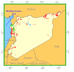
Syria is lightly forested with less than 3 percent of the country covered by forest or other wooded land. The country is divided by the Jebel an-Nusariyah mountain range, with the east comprising inland steppes, which give way to the Syrian Desert. West of the mountains is a fertile coastal strip, where the predominant vegetation is maquis scrub dominated by Quercus spp.. In biblical times, Syria had extensive montane forests. These have largely been cleared or degraded and only remnants of mixed-coniferous forest remain. The predominant species include Abies cilicica, Pinus halipensis, and P. brutia. Syria has established a moderately large area of plantations based on Cupressus, Pinus and Eucalyptus species. Syria has a modest network of protected areas with State Forest Protection Zones providing the most substantive forest conservation measures.
Forest Types
Geographic Description
The Syrian Arab Republic, located in south-western Asia, is bounded on the north by Turkey, on the east by Iraq, on the south by Jordan and Israel and on the west by Lebanon and the Mediterranean Sea. It has an area of 185 180 km2.
The coast is a narrow plain that extends along the Mediterranean Sea from Turkey to Lebanon. Paralleling the coast are mountains running mostly north and south. These include the Jabal an Nusayriyah range east of the coast; the Anti-Lebanon Mountains along the border with Lebanon; and the Jabal ad Duruz, a mountain south-east of the Anti-Lebanon range. Mount Hermon, in the Anti-Lebanon Range, is the highest point in the country at 2814 m.
Much of the rest of the country consists of a plateau that is bisected in the north-east by the valley of the Euphrates (known in Syria as Al Furât) River. The plateau area north of the Euphrates is called the plain of Al Jazîrah. The semicircular plateau area in the south-east is part of the Syrian Desert.
The Euphrates, the longest river in Syria, flows diagonally across the country from Turkey in the north to Iraq on the east. The second longest river, the Orontes, originates in the Lebanese portion of the Anti-Lebanon Mountains and flows north through western Syria to Turkey.
Moist sea winds give the coastal region a mild, humid Mediterranean climate. Temperatures average about 9° C in January and about 27° C in July. About 1 000 mm of rain falls there yearly. The mountains to the east are cooler, averaging about 5° C less in both summer and winter. Little rain falls in the valleys and plains east of the mountains. Temperatures there average about 5° C in January and about 31° C in July.
Forest Industry
Forest Map