Forest Resource
Overview
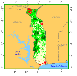
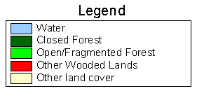
Compared with other Gulf of Guinea countries, Togo is relatively lightly forested. Togo has around 23 percent forest cover with an additional 59 percent of other wooded land. The majority of the forest and woodland is savannah, which extends from the Guinean into the Sudanian vegetative zone. In the plateau region, a dense savannah is characterised by species such as Daniellia oliveri and Butyrospermum paradoxum. Further north, Sudanian-type species, such as Khaya senegalensis and Prosopis africana predominate, along with Black rhun palm (Borassus aethiopium). Stands of closed forest in Togo are mainly semi-deciduous montane forests in the Akwapim Togo ranges, with Antiaris africana and Chlorophora excelsa among the characteristic species. Togo has established modest areas of Eucalyptus and Tectona grandis plantations. The country has a relatively extensive network of protected areas including 3 national parks. Around 4 percent of the country’s forests are inside protected areas.
Forest Types
Geographic Description
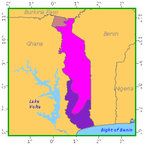
The Togolese Republic lies on the edge of the Gulf of Guinea between latitudes 6° 10´ and 11° 10´ N and longitudes 0° and 1° 40´ E. It has an Atlantic seaboard of 56 km, then stretches inland to the north for 540 km, covering a total area of 56 785 km2. It is bounded on the north by Burkina Faso, on the east by Benin, on the south by the Gulf of Guinea (an arm of the Atlantic Ocean) and on the west by Ghana.
In the south of Togo is a narrow, low-lying coastal belt containing a series of inland lagoons. To the north lies a plateau region that increases in elevation from about 60 m in the south to about 425 m and becoming more rugged in the north-east. The Precambrian Atakorian chain (the Togo Mountains, the Atakora massifs and the Fasao chains) stretch from south-west to north-east and cover much of western Togo. Mont Agou (Pic Baumann) in the south-west (986 meters) is Togo’s highest point. To the north of the hills lies a plateau drained by the Oti River. The Mono River and its tributaries drain much of the southern part of the country.
Although Togo is situated near the centre of the southern coast of West Africa, it has a very particular climate. Although it is tropical, with temperatures averaging 27° C, the cooling effect of cold ocean currents severely reduces convection, which in turn has a major effect on the water cycle of the region. The configuration of the mountains also has a marked effect on annual rainfall, which varies from 850 mm (in the coastal zone) to 1 500 mm (at Bafilou and Badou). Temperatures are fairly constant, but seasonal variations, which are very low in the coastal zone (with high humidity), increase farther north (the continental aspect of the climate). Daily variations of 15° to 20° C can occur in the north during the harmattan season. Two zones can be distinguished on the basis of geography and relief, a sub-equatorial zone with two rainy seasons (March to July and October to November), confined to the coastal area, and a tropical zone with one rainy season of varying length (usually from April to July), covering most of Togo.
Forest cover Vegetation
Introduction
The following descriptions are based on the ecological map of Togo with its eco-floristic divisions and corresponding descriptions (FAO/PNUE, 1980). Apart from bioclimatic and physiographic criteria, the main floristic elements (solely the arborescent woody species) were taken into account in defining the various zones on this map. In this classification, “closed forest” indicates a higher than 80% woody cover, “open forest” a 50 to 80% cover, “savannah woodland” a 20 to 50% cover, and “tree savannah” or “shrub savannah” a 2 to 20% cover.
Closed Forests
Broadleaved
- Semi-deciduous and deciduous forest in the region of the upper basin of the Mono and Ogou, generally under 300 m, belonging to the lowland “dry continental” eco-floristic zone. This archipelago of forest islands and gallery forests, none with an area of over 500 or 600 ha, lies in the east of the country between latitudes 8° 15´ and 9° N (the Abdoulaye region) in the midst of Guinean savannah. Many of the islands are found in the Abdoulaye reserved forest.
The dominant storey is of medium height (15 to 25 m) in deciduous and dry stands, and higher (25 m) in semi-deciduous and gallery forests. It is interesting that the species frequency is the same in deciduous and semi-deciduous forests, with the most common species being Antiaris africana, A. welwitschii, Ceiba pentandra, Khaya senegalensis, Chlorophora excelsa, Triplochiton scleroxylon and Afzelia africana. Other species found in both semi-deciduous and deciduous forests are Khaya grandifolia, Anogeissus leiocarpus, Berlinia acuminata, Bombax buonopozense, Cola cordifolia, Diospyros mespiliformis and Erythrophleum guineense.
- A mosaic of semi-deciduous and dry deciduous forests on the slopes of the Danyi plateau and Mounts Togo, Haito and Agou, belonging to the sub-humid medium-altitude (300 to 900 m) eco-floristic zone. This is a mosaic of montane forests and mountain-slope forests on the slopes of plateaux in south-west Gogo (Danyi, Akposso) and mountains east of these plateaux. These forests rise from the peneplain (250 m) and up the sides of mountains reaching 986 m (Mount Agou) and plateaux reaching 800 to 900 m. The slopes of the plateaux are generally very steep, making them hard for farmers to cultivate, so that several good slope forests have survived.
Fires and permanent crops are the most destructive factors for these forests, which thus hold out longest in the damper places (valleys and wooded slopes). However, people are encroaching here as well, and slowly but surely cutting away at the valley forests, which are then replaced by savannah. And degradation is also qualitative since farmers have been occupying most of these forests for many years, growing coffee and cocoa (and also maize, cassava, etc.) wherever the forest is open enough.
Large trees, often exceeding 25 m (75% of the total for forests over cocoa and coffee, and 35% for others) form the dominant storey in these stands and the cover is usually open, as a result both of growers’ removing some of the trees to allow a little light to reach their coffee and cocoa and of logging in the case of stands with no under-cropping. Nevertheless, although this forest still has plenty of large trees, it contains very few species, mainly Chlorophora excelsa, Khaya grandifolia, Pycnanthus kombo, P. angolensis, Antiaris africana, Triplochiton scleroxylon, Ceiba pentandra, Mitragyna ciliata and M. stipulosa.
- Semi-degraded forest with widespread cropping, belonging to the lowland “dry coastal” eco-floristic zone. This type occurs in the south-west part of the country and forms a broken strip between Palimé and Keve, then extends from Keve-Assahoun to the north-east (Tsagba-Asrama) and ends with the last remnants of the Tetetou and Togodo forests. The zone has relatively high rainfall (between 1 100 and 1 400 mm) and an equatorial climate. It is very flat, with a slight slope from Palimé, at about 200 m, to the coast.
Most of these semi-deciduous forests have been invaded by shifting cultivation or cash crops (coffee, cocoa) so that their cover is rarely closed. Both forest and dry-savannah species are found, the most common being Ficus spp., Sterculia tracagantha, Phyllanthus discoideus, Daniellia oliveri, Butyrospermum paradoxum, Bridelia spp., Antiaris africana, Albizia zygia and the Elaeis guineensis palm.
Forest Industry
Broadleaved
- Mainly tree savannah, but also savannah woodland, shrub savannah and cultivated savannah in the centre of Togo, belonging to the lowland “continental” eco-floristic zone (an annual rainfall of 1 100 to 1 300 mm, with three to five dry months). These stands cover a major part of Togo, running from latitude 6° 45´ to 11° N – a very extensive ecological zone. Total rainfall varies relatively little throughout the zone, and floristic composition varies according to the length of the ecologically dry season. Population density is very high in some areas so that human impact through fire, cutting and cultivation is widespread, often resulting in a very impoverished and degraded pyroclimax forest.
This savannah, including the parts where plant cover has been degraded through human action, covers about 60% of the country. The same typical woody species are found everywhere, the differences between formations (tree savannah, savannah woodland or shrub savannah) arising solely from the presence or abundance of secondary species. The most common species are Daniellia oliveri and Butyrospermum paradoxum, while Afrormosia laxiflora, Annona senegalensis, Burkea africana, Gardenia ternifolia, Nauclea lancifolia, Pterocarpus erinaceus, Stereospermum kunthianum and Strichnos spinosa are also frequent.
- Riparian formations in the Oti valley – open forest, palm savannah and seasonally flooded grasslands – belonging to the lowland “dry continental” eco-floristic zone. The periodically flooded Oti valley lies in the north-east and is moderately populated (10 to 15 people per km2), mainly by growers of millet, sorghum, bean, groundnut and rice. Its vegetation tends to be highly varied. The patches of forest are not gallery forests in the usual sense of the term, in that they do not necessarily grow along water courses, but tend to be small edaphic formations found on sites with very specific characteristics, particularly deep soils, sometimes flooded, alongside water or with a water table close to the surface. The most common species in these patches of open forest are Khaya senegalensis, Mitragyna inermis, Acacia sieberiana, Parinari excelsa, Prosopis africana, Tamarindus indica, Anogeissus leiocarpus, Balanites aegyptiaca, Mimosa pigra and Terminalia laxiflora. There are large stands of Borassus aethiopium and many small trees (Mitragyna inermis) and shrubs (Mimosa pigra) on wide grasslands that are sometimes flooded with stagnant rain water.
- Mainly tree savannah, but also savannah woodland and shrub savannah in southern Togo, belonging to the lowland “dry coastal” eco-floristic zone (an annual rainfall of 800 to 1 100 mm, with three to four dry months). This type is found in the same zone as the previous type. Apart from the degraded forest islands already described, the vegetation is very mixed (with a woody layer and a grassy layer). The savannah of southern Togo has a different composition from that of the centre, with a large amount of Butyrospermum paradoxum and Combretaceae. Some remarkable gallery forests are found within this Sudanian-type savannah, containing a large number of closed-forest species such as Antiaris africana and Cola cordifolia alongside Butyrospermum paradoxum and Acacia campylacantha. However, large parts of these bottomlands suffer considerable pressure from farmers because of their fertile soil, and in many instances the gallery forests are now very degraded. Savannah along roads has suffered degradation, but the human presence is less in the interior. The Sudanian nature of these formations is indicated by the presence of Maytenus senegalensis, Piliostigma thonningii and Stereospermum kunthianum.
- Riparian formations in the Mono, Haho and Sio valleys, belonging to the lowland “dry coastal” eco-floristic zone. These are the lower valleys of the three rivers of southern Togo, all periodically flooded to varying degrees. A large part of the natural forest cover of these riparian zones has been replaced either by crops, fallow, secondary plant cover or by degraded forest. Some islands of closed intact forest are still left, with edges marked by a band of lianas and shrubby vegetation. Pterocarpus santalinoides, Dialium guineense and Cola laurifolia are the main species within them, and there is practically no undergrowth. Outside these closed stands there are seasonally flooded plains, with thickets of trees and shrubs (Ceiba pentandra, Albizia spp., Spondias mombin, Cola cordifolia, Afzelia africana, Lonchocarpus spp., Triplochiton scleroxylon, Chlorophora excelsa and Mitragyna inermis) situated within grasslands.
- “Lions’ den” open forest, belonging to the lowland “very dry continental” eco-floristic zone (an annual rainfall of 900 to 1 100 mm, with five to six dry months). The “lions’ den” is an alluvial plain in northern Togo, situated at the foot of the cliffs of Dapaong in the north and Nano and Boumbouaka in the south. The “den” is in fact only a part of the plain, but since it was the only part of this zone declared reserved in 1954, it contains a rich and varied plant cover. However, this vegetation is threatened with serious degradation as a result of illicit farming activities, indiscriminate felling of live trees and the permanent presence of a herd of elephants. Its 1 250 ha are crossed by several channels that carry water only during the rainy season. A number of large ponds are also filled with stagnant water on clay soils.
Ficus spp., Syzygium guineense, Daniellia oliveri, Afzelia africana, Lannea welwitschii, Terminalia macroptera and Tamarindus indica are found in the drier parts. Gallery forests are often well developed and contain Khaya senegalensis, Manilkara lacera, Cassia sieberiana, Pentadesma bitira, Raphi spp., Diospyros mespiliformis, Anthocleista nobilis and Vitex spp. Flood-prone and hydromorphic areas especially have a grassy cover of Andropogonae.
- A complex of medium-altitude open forest, semi-deciduous forest, savannah woodland, tree savannah and shrub savannah, as well as savannah now heavily under cultivation, belonging to the dry to subhumid medium-altitude eco-floristic zone (300 to 800 m). This type of vegetation more or less covers the Fazao Mountains and the Atakora range (Mounts Siambénou, Defalo, Amato, etc.), as well as a number of mountains north of Lama Kara. These areas tend to have a good rainfall (1 300 to 1 500 mm). However, there is a marked decrease north of the Bafilo Mountains, where the dry season also becomes longer as the effects of the harmattan are felt. This means that the vegetation gets very dry and fires have a more serious impact. The terrain is varied, with plateaux, steep cliffs, depressions and moist ravines. Population density is also varies greatly. The Fazao mountain region is the most sparsely populated in Togo (with less than 6 persons per km2), with vast, uninhabited, almost inaccessible areas, whereas the Atakora region, the Lama chain and some parts of the Bafilo Pewa Mountains are densely populated, and hence denuded and degraded, with consequent major erosion.
The zone is covered by a mosaic of different formations, ranging from patches of semi-deciduous forest in the Bafilo, Malfakassa and Fazao Mountains, which account for only a small part of the plant cover, to scattered grassy cover. Open forest predominates, with Afzelia africana, Anogeissus leiocarpus and Isoberlinia doka. Semi-deciduous forest, mainly in the form of gallery forests, contains Dialium guineense, Antiaris africana and Berlinia grandiflora. Medium-altitude savannah (woodland, tree or shrub) contains Monotes kerstingii, Isoberlinia doka and Uapaca somon.
Other wooded land
Shrubs
- Saxicoline shrub formations, belonging to the lowland “very dry continental” eco-floristic zone. This type of vegetation is found in the far north of the country, covering the sandstone cliffs of the Nano, Pana, Boumbaka and Dapaong region. The two massifs run more or less east-northeast to west-southwest and vary in altitude between 300 and 520 m, rising from the south toward the north and then falling in almost vertical cliffs to the plains of the far north, where the average altitude is 250 m. They cover only about 230 km2, i.e. 0.4% of the country. The climate of the region is Sudanian tropical in type, with a total average rainfall of 1 050 mm, spread over about 70 days. The harmattan has a very strong effect here, and the temperature on this rocky terrain rises very high in the dry season. Small pockets of vegetation protected by the rocks are sheltered from fires, but most of it is burnt off each year. Population density is high, with intensive grazing.
- Given such difficult conditions for natural vegetation, these saxicoline formations are poor both in appearance and in floristic terms. The trees are mostly stunted and twisted, having suffered from fire, browsing herds and cutting. The most common species are Syzygium guineense, Terminalis glaucescens, Combretum glutinosum, Euphorbia spp., Acacia spp., Entada spp. and Sterculia setigera. Anogeissus leiocarpus, Butyrospermum paradoxum, Prosopis africana, Daniellia oliveri, Bridelia ferruginea, Khaya senegalensis, Vitex cuneata, Parinari excelsa and Diospyros mespiliformis are found on deeper soil.
- Tree and shrub savannah with major inroads from cultivation, belonging to the lowland “very dry continental” eco-floristic zone. Situated roughly to the west of the Oti river in northern Togo, this region is the driest in the country, a feature exacerbated by two major factors – the influence of the harmattan and human interference and its consequences. It is a very densely populated region. In addition to the very high occupation of land by crops (millet and cotton), it is also overgrazed by cattle, goats and sheep. The remaining trees are cut for firewood or for forage for goats and sheep. In densely populated areas, almost all the surviving species are protected because of their fruit or other products that can be eaten or otherwise used; these include Butyrospermum paradoxum (fruit and seeds), Tamarindus indica (fruit), Balanites aegyptiaca (fruit), Parkia biglobosa (flour from its pods) and Ficus spp. (fruit).
- The unprotected species (Acacia mellifera, Combretum spp. and Entada africana) often indicate a very degraded environment. The grassy cover tends to be steppe-like (pseudo-steppe), given the height of the grass and the space between clumps.
- Shrub savannah, belonging to the medium-altitude (300 to 900 m) subhumid eco-floristic zone, with an annual rainfall of 1 400 to 1 700 mm. This type of vegetation is found at altitudes between 600 and 950 m, mainly on the Precambrian plateaux of Danyi, Akposso and Akebou in south-western Togo. The region has a moist montane tropical climate, with relatively low temperatures and evaporation, which means that it retains its humidity for the greater part of the year. Population density is fairly high at 20 to 40 persons per km2. The region is important for coffee and cocoa production. Taro and rice are the main food crops.
Two different environments can be distinguished on these plateaux mostly on the basis of soil conditions. The first has poor productive potential because of the shallowness of the soil and is covered by scattered shrub or grass savannah, while the second is post-forest savannah, with a considerable number of forest genera (Chlorophora, Antiaris, etc.), as well as savannah genera (Entada, Bridelia, Trema, etc.). Savannah derived from forest (on deep soil) would quickly develop into forest given the right ecological conditions so long as it is not already too degraded.
Forest fallow
A mosaic of cultivated and fallow areas succeeding semi-deciduous forest on basaltic soil, belonging to the lowland “dry coastal” eco-floristic zone. Situated in the far south of the country, it has the lowest rainfall (770 to 1 100 mm), with very marked annual variation, and its soils belong to the terre de barre group. Altitude ranges from 30 to 120 m. The plateau slopes gently towards the south and is crossed by the Lama depression, which stretches from the region south of Tove towards the north-east (Tabligbo). Since this land has been intensively cultivated for centuries, the climax vegetation has been almost totally replaced by fallow and cropped land. The most important feature of these man-made landscapes today is without doubt the oil palm, Elaeis guineense. The offshore bars along the coast contain groves of coconut palms, Cocos nucifera. Together with natural or man-made palm stands, the intricate patchwork of fallow lands is the dominant feature of the southern Togolese landscape. Practically every intermediate stage between semi-deciduous forest and cultivated fields can be found in these fallow areas. As soon as fallow land is abandoned, closed thickets are the first stage to follow, with the most common species including Dialium guineense, Drypetes floribunda, Vernonia colorata, Lecaniodiscus cupanioides, Morinda lucida, Albizia zygia, Fagara xanthoxyloides and Malacantha warnecki. After being left for several years, these thickets are cut down and the land is turned into fields. Almost the whole coastal region is under this system of rotation between shrubby thickets and crops, especially in view of the very h