
Overview
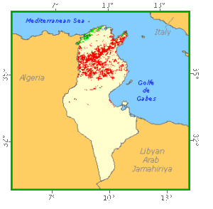
Tunisia is lightly forested with forests covering less than 4 percent of the country’s land area. The majority of vegetation is found in the northern half of the country, the south extends into the Sahara desert. Closed forests in Tunisia are largely confined to the Kroumerie mountains adjacent to the northern coast. These are mixed oak forests with common species being Quercus suber and Q. ilex. Small stands of Pinus halipensis occur around the Cap Bon peninsula. Relict areas of Acacia raddiana savannah are found in Bou Hedma National Park. Tunisia has established extensive areas of plantations, both for production and for sand dune stabilisation. Species utilised include Pinus halipensis, P. pinaster, Eucalyptus spp., Acacia spp., and Casuarina equisetifolia. Tunisia has a modest network of protected areas encompassing around 2 percent of forests.
Forest Types
Geographic Description
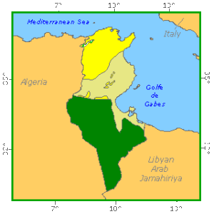
The Republic of Tunisia, located in northern Africa, is bounded on the north and east by the Mediterranean Sea, on the south by Libya and on the west by Algeria. Its total area is 163 610 km2.
Two low-lying branches of the Atlas mountain range extend into Tunisia. In Tunisia, the northern branch is called the Atlas Mountains and the southern branch the Tabassah Mountains. But the mountains are mostly less than 600 m. The highest, Mount Chambi, is just 1 544 m above sea level. Hills, grassland and fertile valleys lie between the mountain ranges. From the Tabassah range, the land descends across a plateau to the Sahara in the south and to a coastal plain in the east. The fertile coastal plain extends along the east coast from Sfax to Tunis.
The country’s only major river, the Majardah, crosses the region from west to east, emptying into the Gulf of Tunis.
In general, a mild Mediterranean climate prevails in the north while toward the south the climate becomes progressively hotter and drier. In the north, temperatures average 11° C in winter and 25° C in summer. The northern regions have a rainy season that lasts from October to May, with an average annual rainfall of about 610 mm but varying greatly from year to year. Annual rainfall decreases to the south and only 200 mm or less falls in the Sahara.
Forest cover Vegetation
Introduction
The Republic of Tunisia can be divided into five bioclimatic zones, increasing in dryness from north to south, with soil cover showing a similar succession. Thus, the humid zone (annual rainfall of over 1 000 mm) has brown soils rich in organic matter and is home to cork and zeen oak; the subhumid zone (annual rainfall of 700-1 000 mm) has clayey soils (vertisols); the semi-arid zone (annual rainfall of 500-700 mm) has calcareous soils for the most part; the arid zone (annual rainfall of 300-500 mm) has saline soils (Kairouan), brown steppe soils and skeletal soils (regosols and lithosols); and the Saharan zone (annual rainfall of under 300 mm) has soil paved with calcareous slabs and gypseous crusts.
Tunisia has five main natural regions. The Tell, with a humid climate in the north, is the extension of two Atlas ranges; this region is made up of ranges and valleys, with a maximum altitude of 1 500 m. Southeast of these mountains, the central steppes form an intermediate platform of high hills and plateaux with a semi-arid climate. This region ends in the coastal region of the Sahel in the east of the country. Chotts, shallow salt lakes, lie between these steppes and the southern part of the country; these depressions lie at very low altitudes and stretch as far as the sea. South of the chotts, the country ends in the Sahara Desert.
The natural vegetation is closely linked to bioclimatic zone and soil type, varying in composition, structure, density and height from north to south. The thickest and floristically richest forests are found in the north (Kroumirie and Mogod), becoming more open and lower in the centre, while in the south they are rare, very fragile, and scattered.
The main species in natural forests, confined basically to the humid and subhumid zones, are cork oak (Quercus suber), zeen oak (Q. faginea) and maritime pine (Pinus pinaster) in the north, and Aleppo pine (P. halepensis) in the central region. However, there are other forest communities made up of secondary species: thuja (Tetraclinis articulata), holm oak (Quercus ilex), kermes oak (Q. coccifera), etc. All these species are found both in pure stands and also mixed with two or more other species. The edaphic and climatic requirements of the various species mean that broadleaved species and maritime pine are confined to the northern and Cap-Bon regions, while Aleppo pine is found mainly in the central and central western natural regions of the country.
Steppes predominate in the arid zone, especially alfa (Stipa tenacissima), sagebrush (Artemisia herba alba) and jujube (Ziziphus lotus) steppes. The subdesert zone contains bushy and herbaceous vegetation adapted to this very dry climate, while the desert region contains only very sparse non-woody vegetation.
Human interference also plays a major role and has considerably transformed the appearance of the vegetation, so that certain plant formations have replaced forests destroyed by clearing, fires and overgrazingCmaquis in the north, garrigue in the centre, and steppes in the centre and south of the country. Except for zeen oak forests, Tunisian oak forests suffer similar degradation, so that they are changed into shrubland with a certain number of trees (a few metres in height), then into low garrigue (a few metres in height), and finally into bush steppe.
Closed Forests
Broadleaved
1. Oak forests
Predominantly cork oak (Quercus suber) forests are basically found in the north and northwest of the country, between Bizerte and the Algerian border, and here and there in more humid regions (Cap-Bon and the Dorsale). This is by far the commonest species of oak in Tunisia, growing at altitudes up to 1 200 m on soils lacking calcium. It requires light, humidity and warmth, and is thus found on the southern slopes of mountains.
With a height between 6 and 15 m depending on local conditions, cork oak usually has a bushy undergrowth 2 to 4 m in height. Plant associations may differ slightly depending on climate, altitude and soil type. Mastic (Pistacia lentiscus), wild olive (Olea europa) or Chamaerops humilis are found at low altitudes, while cytisus (Cytisus salvifolius) predominates towards 450 m. In open stands, strawberry tree (Arbutus unedo) and tree heath (Erica arborea) grow alongside cork oak. In humid regions it is combined with Quercus faginea, Alnus glutinusa and Prunus avium. When degraded, these formations are replaced by maquis.
Predominantly zeen oak (Quercus faginea) forests are found in the most humid regions of Kroumirie at altitudes above 700 m and on cool, shady slopes. In a few places they grow right to the edge of the sea, but are in these cases confined to shady slopes, cool, damp ravines and permanent wadis.
These are pure stands, although zeen oak can also grow together with cork oak. The species can reach a height of 20 m, with various associated shrubs and bushes, depending on soil type and altitude, for example, Cytisus triflorus and Daphne gridium on calcareous soil, and Cistus laurifolius and Viburnum tinus on non-calcareous soil. In general this type of forest has suffered little degradation.
2. Forest with a predominance of other oak species
Holm oak is found in pure stands only in small areas on the Dorsale, above 1 000 m, but is more often mixed with Aleppo pine in low coppices, covering large areas in the semi-arid, subhumid and arid zones. It is the most adaptable oak in terms of climate and soil. It can grow very tall (up to 15 m) on mountain tops. In optimum conditions, it forms a closed forest with a thick cover, but can also be found, depending on local conditions, in more open formations with shrub and herbaceous layers.
Kermes oak is found in regions with maritime influences along the coast of northern Tunisia, on sandstone soil between sea-level and 600 m. A subhumid climate with a mild winter provides optimum conditions for its growth, although it is also found in humid and semi-arid zones. It can grow to 2 or 3 m, but reaches only 1 m on calcareous soil. It is sometimes found in association with Phoenician juniper (Juniperus phoenicea), mastic, etc.
Afares oak (Quercus afares) forests are found basically as residual stands, above 900 m.
Forest Industry
Coniferous
Predominantly Aleppo pine (Pinus halepensis) forests are scattered throughout the country, from sea-level to 1 400 m, but most stands are found in the central-west regions (Kef and Kasserine). This forest tree covers the largest areas in Tunisia, even though it has suffered major human pressure for a long time. Degraded areas constitute rosemary (Rosmarinus officinalis) garrigues in the centre west, and sometimes alfa or sagebrush steppes in the south.
Along the northern coast, Aleppo pine is found in association with maritime pine and kermes oak, but these associations vary, depending on the distance inland from the coast. Aleppo pine is found in association with thuja, heather (Erica multiflora), prickly cedar (Juniperus oxycedrus), etc., in different places.
Predominantly maritime pine (Pinus pinaster) forests are found in natural stands only northwest of Kroumirie. A calcifugous species, maritime pine is usually found in association with cork oak, and rarely occurs as pure stands.
Open forests
Coniferous
Predominantly thuja (Tetraclinis articulata) forests are primarily present in zones with a maritime influence and a semi-arid bioclimate (south of Cap-Bon, northeast of the Dorsale). Thuja usually grows on calcareous and siliceous soils from the coast up to 700 m.
Vegetation with a basis of thuja appears as garrigue, with a composition close to Aleppo pine garrigue. It can grow to a height of 12 or 15 m, and the narrowness of its crowns allows many sun-loving species to flourish: Cistus villosus, Lavandula multifida, etc. When degraded, thuja stands give way to heather or rosemary.
Formations with a basis of Phoenician juniper (Juniperus phoenicea) are found in the central and southern mountains in the semi-arid zone, and also on the coast. They can be found on very dry slopes, especially in the south.
Phoenician juniper is sometimes found in association with prickly cedar which grows abundantly in degraded Aleppo pine forests. It often grows in association with Aleppo pine in the driest zones (especially on the edge of dry steppes), where it gradually replaces it. These are very open formations less than 7 m in height
Forest Map
Other wooded land
Shrubs
Tree maquis and tree garrigue (with broadleaved species and/or conifers) are formations containing patches of certain forest species such as pines and oaks, while shrubs and bushes (mastic, strawberry tree, kermes oak, holm oak, thuja, etc.) are found in the lower storey. These formations are degraded versions of natural forests of cork oak (maquis) and Aleppo pine (garrigue).
Garrigue is a low, sparse woody formation on bare soil or soil with a grassy cover. It is found on calcareous soil in arid and semi-arid zones (from the Dorsale to Cap-Bon, following a northeasterly line). It is a scanty formation (with a cover of less than 50%), replacing a former Aleppo pine forest, as one phase in the degradation of the latter. Its botanical composition varies according to soil and human pressure (fire, overgrazing, etc.), and different types of garrigue are thus defined according to their composition (e.g. rosemary garrigue). However, juniper (Juniperus sp.), holm oak, rosemary and Ampelodesma mauritanica are particularly frequent.
Maquis is found on siliceous soil (sandstone or sandstone-clay) in humid and subhumid zones. Its ecological range in Tunisia is directly linked to the nature of the substratum and to hydromorphic conditions. It is a thick, vigorous woody formation, taller than garrigue (over 1.10 m). It contains a whole range of shrub species, with a predominance of strawberry tree, heather (Erica spp.), myrtle (Myrthus communis), mastic and phillyrea (Phillyrea angustifolia).
References
Institut des régions arides (1994). Végétation forestière et préforestière de la Tunisie. Typologie et éléments pour la gestion. Revue des régions arides. 6/94. Medenine, Tunisie, 299 p.
Ministère de l´Agriculture (1986). SILVA. Conférence internationale sur l´arbre et la forêt. L´arbre et la forêt en Tunisie. Paris, 5-7 février 1986.
Ministère de l´Agriculture, Direction Générale des Forêts (1995). Résultats du premier inventaire forestier national en Tunisie. 88 p.
Ministère de l´Agriculture, Direction Générale des Forêts (1995). Résultats du premier inventaire pastoral national en Tunisie. 154 p.
Ministère de l´Agriculture, Direction Générale des Forêts (1996). Plan de développement des ressources forestières et pastorales en Tunisie. 1- Analyse et problématique générale du secteur forestier (version provisoire).
Seigue A. (1985). La forêt circumméditerranéenne et ses problèmes. Techniques agricoles et méditerranéennes. G. P. Maisonneuve & Larose Ed. et A.C.C.T., Paris, France. 502 p.