Forest Resource
Overview
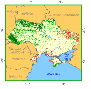
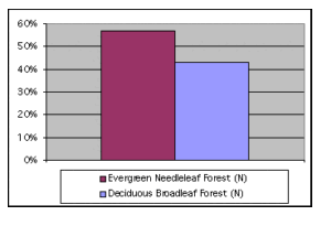
Ukraine is located on a vast plain to the north of the Black and Azov Seas. Forest and other wooded land, mainly mixed and steppe forests, accounts for one sixth of the land area, which is predominantly devoted to agriculture. Nearly two thirds of the forest is available for wood supply; the remainder is not available mostly for conservation and protection reasons. About half the forest is classed as semi-natural and most of the rest as plantations; there are only small areas of forest undisturbed by man. Broadleaved species make up roughly half the growing stock, with oaks, beech, birch and poplars among the most common. Pines, Norway spruce and firs are the main coniferous species. A larger proportion of forest stands than ´normal´ are in the young and middle-aged age classes, many of them planted since the Second World War. A particularly important function is soil protection from wind and water erosion. Partly because of the young age-class structure, fellings are less than half the net increment, resulting in a strong expansion in growing stock in recent decades. All forests are State owned. Collection of non-wood forest products is an important activity of the local population.
Forest Types
Geographic Description
Ukraine, located in eastern Europe, is bordered on the west by Poland, Slovakia, and Hungary; on the south-west by Romania and Moldova; on the south by the Black Sea and Sea of Azov; on the east and north-east by Russia; and on the north by Belarus. The country measures 1 316 km east to west and 893 km north to south, with a total area of 603 550 km2.
The lowlands of the Dnepr River and the bogs and swamps of the Pripyat Marshes lie in northern Ukraine. The Northern Ukrainian Upland consists of a low plateau in north-eastern Ukraine. Most of the central part of the country is a fertile central plateau, part of the plain that covers much of eastern Europe. The Donets Basin, often called the Donbas, lies in the eastern part of this plateau. The Dnepr River flows through the centre of the plain.
The eastern parts of the Carpathian Mountains rise in western Ukraine. Ukraine’s highest peak, Mount Goverla (also spelled Hoverla), soars 2 061 meters.
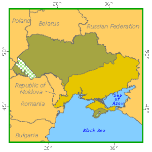
Ecological Zones
Forest Industry
A coastal plain extends along the coasts of the Black Sea and the Sea of Azov and includes most of the Crimean Peninsula. Its coastline has cliffs and many shallow lagoons. The Crimean Mountains rise in the southern part of the Crimean Peninsula. The mountains climb gradually from the north but slope steeply to the Black Sea in the south. The highest point in the Crimean Mountains, Roman-Kosh, stands 1 545 meters above sea level.
The Dnieper flows through central Ukraine and forms the country’s main river network. Other major rivers are the Dniester (Dnister), the Bug (Buh), and the Southern Bug (Pivdennyy Buh) in the west, and the Donets in the east. The Danube (Dunay) forms part of Ukraine’s border with Romania in the extreme south-west
Most of Ukraine has a continental climate with cold winters and warm summers. Temperatures in Kharkov in eastern Ukraine average about -7° C in January and 20° C in July. Precipitation ranges from about 750 mm a year in the north to about 250 mm in the south. Rainfall is highest in June and July. The weather is colder and wetter at higher elevations in the Carpathian and Crimean Mountains.