
Forest Resource
Overview
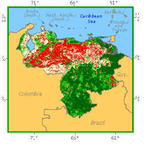
Venezuela is extensively forested with around 50 percent forest cover. The majority of forests are in the south and east of the country, an extension of the Amazon region. These are humid tropical forests comprising an association of hardwood trees and palms. Important commercial species include ceiba (Ceiba petandra), taparo chuco (Couroupita guianensis) and carapa (Carapa guianensis). Areas of montane forest also occur on, for example, the tepui mesas of the Guiana Highlands in the south, and are particularly significant in the Cordillera de Merida. Common montane species are Gyranthera caribensis, Sloanea spp., and members of the Lauraceae family. The Orinoco Delta is home to extensive swamp and mangrove forests, while areas of dry forest occur in the Maracaibo Basin and some coastal areas. Venezuela has extensive forest plantations based mainly on Pinus species. Venezuela also has an extensive network of more than 80 protected areas encompassing more than 20 percent of the country´s territory.
Forest Types
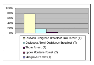 +426,569 ac Exotic Species Plantations (T)
Geographic Description
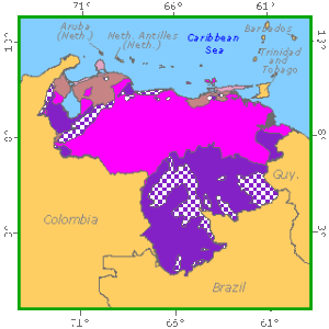
The Republic of Venezuela, located in northern South America, is bounded on the north by the Caribbean Sea and the Atlantic Ocean, on the east by Guyana, on the south by Brazil, and on the south-west and west by Colombia. The total area is 912 050 km2.
The country can be divided into four major geomorphologic zones:
- The mountain ranges of the north-west, consisting of a branch of the Andes and the coastal mountain range, with elevations from 500 to 5 000 m. The highlands extend from south-west of the Maracaibo Basin across northern Venezuela. The Merida Range consists of mountain ranges and high plateaus. Pico Bolivar, the highest point in Venezuela, rises 5,007 meters above sea level. The central highlands consist of two parallel mountain ranges along the Caribbean coast with fertile valleys between them. The north-eastern highlands consist of low mountains and hilly land.
- The Llano, an immense plain of tertiary rocks and alluvial deposits lying between the Andean Highlands and the Guiana Highlands. Much of it is under 50 m elevation. The Orinoco River, which begins in the Guiana Highlands, flows from west to east along the southern border of the Llanos, flooding huge areas during the wet season. The river and its tributaries drain most of Venezuela. The Orinoco extends 2,066 km and is the longest river in the country.
- The Guiana Highlands of Precambrian rocks lying to the south of the Llanos and the Orinoco river, with elevations less than 3 500 m. The highlands cover nearly half of Venezuela and extend into Brazil and Guyana. The chief ranges are the Sierra Parima and Sierra Pacaraima, which form part of the boundary with Brazil. Swift-flowing rivers have deeply eroded the region’s high plateaus and tropical forests cover much of the southern part of the region.
- The delta of the Orinoco is formed from recent alluvial deposits and is subject to periodic flooding. It is associate geomorphologically with the Maracaibo Basin lying in north-western Venezuela and consisting of Lake Maracaibo and the lowlands around it. Lake Maracaibo is the largest lake in South America, covering 13 512 km2.
The climate of Venezuela is tropical on the Llanos and along the coast, and temperate in the mountainous regions. The average daily temperature range in January in Caracas is 13° to 24° C and 23° to 32° C in Maracaibo; in July the range is 16° to 26° C in Caracas and 24° to 34° C in Maracaibo. Annual rainfall averages about 3 000 mm in the Perija Mountains, which are west of Lake Maracaibo, and in the southern Guiana Highlands, although some areas in the highlands receive 8 000 mm yearly. In contrast, much of the Caribbean coast is dry, and some areas receive only 120 to 400 mm of rainfall yearly. Most of the rest of the country has a wet season from May through November. In the eastern Llanos, annual rainfall averages about 1 000 mm.
Ecological Zones
Forest Industry
Resources Forest cover Vegetation
Natural Woody Vegetation Description
Introduction
In general terms physical factors in Venezuela change from south-east to north-west, with a decrease in humidity and an increase in temperature, length of dry season and sandy texture of soils. The vegetation reflects these changes.
Closed Forests
Broadleaved
Mangrove forests are found in the Orinoco delta and along the banks of Lake Maracaibo, the former stands being larger. The Orinoco delta encompasses a vast branching system of channels around the estuary of the river. In the north it adjoins the tropical rainforest, which is to a large extent very swampy, and there are also dry or moist savannah areas. In the south there is a fairly low swamp forest. Mangrove forests spread a long way inland (40 km) along the banks of waterways and are made up mainly of Rhizophora mangle, Laguncularia racemosa, Avicennia tomentosa, A. officinalis and Conocarpus erecta. Where they are less exposed to the tides, they are mixed with Pterocarpus officinalis, Bravaisia integerrima and Clusia sp. There is no shrub or grass layer. Further inland in the delta, in places not affected by seawater, there is a strip of swamp vegetation on the banks, with a strip of Combretum frangulaefolium shrubs behind this (Grandtner, 1971).
Moist forests (Grandtner, 1971) include all the evergreen rainforest in the area of the Orinoco delta, the Guyanese region, and south-west and south of Lake Maracaibo. It stretches from sea-level up to 400 m, and occasionally to 1 000 m on poorly drained flat or rolling land. The forest is rich in epiphytes, parasites and reeds. There are three or four storeys. The most common species are Couroupita guianensis, Ceiba pentandra, Coumarouna punctata and Carapa guianensis. The upper storey contains Calophyllum brasiliense, Guarea trichilioides, Penteclethra macroloba, Swartzia sp. and palms of the Bactris, Iriartea, Scheelea and Socratea genera, while the lower storey contains species of the Brownea, Grislea, Inga, Luehea, Protium and Trichilia genera. The floristic composition changes depending on region and edaphic conditions, for example cashew (Anacardium excelsum), a major commercial species, is found principally on alluvial soil at the foot of the Andes.
In Venezuelan Guyana, high tropical rainforest is interrupted in drier places by lower types of forest or savannah, for example the Gran Sabana and other smaller areas. There is high, dry savannah on the sandy plateaux of central Guyana. According to Rollet (1967), there is a strong predominance of the following genera in the Guyana region: Eschweilera, Licania, Protium, Pouteria and in some places Alexa. Erisma uncinatum is also very common.
Montane forest is found east of the Tachira depression, essentially in three mountain zones: the Merida range, the coastal range by the Caribbean, and the eastern massif in Sucre and Monagas states. On the other hand, the Perija Mountains, which are a branch of the intermediate mountain range running northwards west of the Tachira depression, are still relatively untouched.
Cloud forest (Grandtner, 1971)) corresponds to the misty climate of the Andes between 500 and 1 700 m. There warm air rises and condenses to form clouds, which then hide the sun, lowering the temperature (by about 5°) and increasing humidity. Temperatures range from 18° to 24° C and annual rainfall from 2 000 to 4 000 mm. This is a broadleaved evergreen forest. Trees are more widely spaced, allowing greater development of intermediate species and a less defined floristic stratification. There are less reeds and more epiphytes and tree ferns.The floristic composition is marked by the large number of arboreal species. The dominant storey (over 45 m in height) is made up of Gyranthera caribensis and the Sloanea, Pterocarpus, Ficus, Lonchocarpus, Calophyllum, Protium and Tabebuia genera, as well as many Lauraceae and palms of the Socratea and Iriartea genera. Valuable species found here include Cedrela mexicana, Guarea sp. Roupala montana, Terminalia sp, Virola sebifera, Rollinia fendleri and Calophyllum brasiliense.
Veillon and Lamprecht classify the forests of the Merida mountains as follows:Low- and medium-altitude Andean montane forest up to 1 800 or 2 000 m with annual rainfall of 3 000 to 4 000 mm. The main families are the Lauraceae, Moraceae, Mirtaceae, Bignoniaceae, Euphorbiaceae and Araliaceae, with a profusion of reeds and epiphytes. (see also Close mixed forest text).
Polylepis forest consists of high-altitude Andean scrub from 4 to 6 m in height, which appears above the continuous tree line and in which Polylepis sericea is the dominant species. It starts in isolated patches at 3 000 m and is found up to about 4 200 m. Loccated exclusively in areas close to Merida. Rainfall ranges from 500 to 700 mm, with frequent frosts.
Deciduous forest (Grandtner, 1971). Where there is a dry season of four to six months with average annual temperatures of 22° to 29° C and rainfall of 1 000 to 1 800 mm, deciduous forest replaces gallery forest on well-drained soil. This is especially seen in the north-west of the country, generally on level terrain. This type of forest is marked by the presence of species that drop their leaves in the dry season, with flat and well-spaced crowns. There are three storeys (the highest reaching 20 or 30 m) containing many species: Swietenia macrophylla, Tabebuia pentaphylla, Astronium graveolens, Calycophyllum candidissimum, etc., and palms such as Copernicia, Attalea, Acrocomia, Oredoxa and Roystonea; Copaifera officinalis, Enterolobium cyclocarpum Spondias mombin, Ceiba pentandra and various cacti are also found here. This type of forest is found especially around Lake Maracaibo (the western zone), south of the Andes and plains region (Llanos). An area of deciduous forest adjoining the moist forest is also found south of the Orinoco in the eastern region and Guyana.
This type of vegetation can be classified as “trade windforests” (bosques alisios) and divided into the following types:
- Forests in the foothills of the Andes on the high plains (llanos altos) with the best soils and good drainage;
- Forests in the low-lying plains (llanos bajos) on periodically flooded and thus poorly aerated soils;
- Gallery and swamp forests on poorly drained soils;
- Periodically flooded or dry rangeland and savannah, which break into the previous types and which become the typical landscape in the treeless plains (llanos sin arboles) of the Orinoco basin;
- Scrubland with shrubs 3 to 4 m high.
Forest Map
Mixed
Veillon and Lamprecht classify the forests of the Merida mountains (see also Closed broadleave text) as follows:
High-altitude cloud forest and the upper limit of Andean cloud forest. The high-altitude cloud forest has Podocarpus montanus and P. oleifolius as its most common species, with thick, short, ill-formed trunks, mixed with other species. Its upper limit is between 3 000 and 3 200 m. Above the tree line in the Merida mountains there is generally a broad belt of scrub about 1 to 2 m in height.
Low-altitude cloud forest (“mixed forest” and “Podocarpus rospigliosii forest”) from 2 300 to 2 600 m with annual rainfall of 2 000 to 2 500 mm.
Mixed type, an evergreen forest with a height of 25 to 30 m. Poorly developed crowns and twisted trunks are common. There is no dominant species.
Podocarpus rospigliosii forest, a mixed forest dominated by this species with heights of 40 to 45 m. The trunks are straight, clean and cylindrical. Alnus jorullensis is also common at this level.
Gallery forests (Grandtner, 1971) are found along rivers, especially the Orinoco and its tributaries, in the plains region and in the Guyana region. Frequent flooding encourages the growth of evergreen species, reeds and epiphytes. Gallery forests range from 5 or 10 m to as much as several kilometres in breadth. The upper storey (over 20 m high) is dominated by Pterocarpus and Podocarpus sp. , accompanied by Guazuma ulmifolia, Lecythis ollaria, Centrolobium orinocense and Ceiba pentandra; the lower storey also includes Capparis coccolobifolia, Acacia glomerosa and Casearia hirsuta, as well as Copernicia tectorum where there is an opening in the upper storey. Further east, gallery forests are dominated by Mauritia minor, accompanied in the shrub storey by Jussiaea lithospermifolia, Cuphea gracilis and Hyptis conferta-excelsa, with grasses below these.
Open forests
Broadleaved
Savannah (Smith, 1972). Opinions vary as to the origin of savannah in Venezuela, with some people holding that it was originally deciduous forest, and others that forest has never been found in these areas. Whatever the case, it corresponds to a very warm climate with very heavy rainfall concentrated in one period of the year. Soils are drier and shallower, or almost non-existent where there has been erosion.
The two main elements of the vegetation are herbaceous plants with surface roots and woody plants with the capacity to penetrate the hard lateritic layer of the soil. The woody elements are shrubs and trees 3 to 8 m tall, such as Curatella americana, Bowdichia virgiloides, Byrsonima crassifolia and the Copernicia tectorum palm. Another palm, Mauritia minor, grows in periodically flooded depressions, forming pure or almost pure stands. In the west the most common palm is Acrocomia, in the east Mauritia minor, and in the centre Copernicia tectorum. Grassy species belong to the Trachypogon, Andropogon and Aristida genera.
Dry forests are found mainly in the coastal regions along the border with Colombia as far as Cumaná, especially in the area of Lake Maracaibo and on the Guajira and Paraguaná peninsulas (Aubreville, 1956; Grandtner, 1971)). The islands off the coast (for example Margarita) also fall within this dry zone, having a very low and irregular rainfall (an annual average of 400 to 600 mm) with a dry season of nine months.
Where dry forest penetrates mountainous areas, hills of over 800 m are covered to the top with xerophytic formations (e.g. Santa Ana on the Paraguaná peninsula). On the other hand, there are moist forests at the same altitude in the mountains on the island of Margarita. One reason could be that the higher altitude of the island causes more clouds and rainfall that falls on the slopes.
Other wooded land
Shrubs
Thorn scrub is a low formation (6 to 10 m in general) made up mainly of small-leaved thorny Leguminosae which drop their leaves for six or more months of the year. Honey or velvet mesquite (Prosopis juliflora) is always present, while Acacia tortuosa, A. flexuosa, Caesalpinia coriara and species of Mimosa, Pithecolobium and Cassia are also common. In more favourable places, some taller trees rise above the forest canopy: Erythrina tamayensis and other species of the Erythrina, Lonchocarpus, Hymenaea and Tabebuia genera, etc. During the rainy season there is a broken grassy ground cover.
Cactus scrub is found in drier areas than the previous type (with an annual rainfall of under 500 mm). Candelabra forms of Cephalocereus moritzianus and Lemaireocereus griseus predominate in the tree layer, reaching heights of 8 m. Honey mesquite is also found here. Below this is a layer of shorter cacti of the Bastardia and Croton genera, reaching heights of 1 or 2 m. Opuntia wentiana and O. caribaea, shorter species of Cereus and others are also common.
Dry scrub is also found in the inner Andean valleys, despite the lower temperatures and the higher rainfall. Here the dryness is a result of the rapid runoff of water from the slopes. The main species are honey mesquite, Jamaica birch (Bursera simaruba), Pilocereussp., Lemaireocereus sp., Opuntia caribaea, Acacia sp. and Croton sp.
References
Aubreville, A. (1956). Le Vénézuela forestier. Bois et Forêts des Tropiques, No. 45. Nogent-sur-Marne, France.
Grandtner, M.M. (1971). Tropical forest formations of Venezuela.
Presented to the Pre-congress of the 12th Pacific Science Congress, tjipajimg, Indonesia
Rollet, B. Inventaire forestier en Guyane Vénezuélienne. CTFT,
Colloque sur le rôle des recherches techniques dans le développement de l?emploi des bois tropicaux en Europe. Nogent-sur-Marne, France.
Smith, R. F. La vegetation actual de la región centro occidental:
Falcón, Lara, Portuguesa y Yaracuy de Venezuela. Un resumenecológico de acuerdo a la foto-interpretación.
UNESCO (1973). Clasificación internacional y cartografía de la vegetación. Série: Ecologie et Conservation.