Forest Resource
Overview
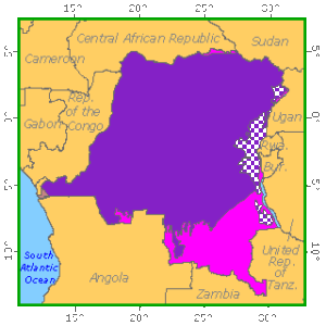
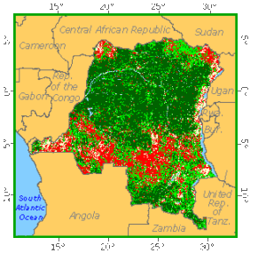
The Democratic Republic of the Congo is heavily forested with 49 percent forest cover and an additional 23 percent of other wooded land. The country has the largest forest area of any African country and contains almost half of Africa’s tropical moist forests. The country has a broad range of forest types with moist evergreen and semi-deciduous forests occupying much of the central and western regions. Large areas of edaphic forest occur in the north-west around the Congo River and its tributaries. Areas of sub-montane and montane forest occupy the eastern highlands and the slopes of the Mitumba mountains. The country has an enormous diversity of tree species. Among the most important commercial timbers are Etandrophragma cylindricum, Khaya ivorensis and Pericopsis elata. The rainforests open out into “miombo” woodlands (Brachystegia-Julbernardia-Isoberlinia association) in the south, along the Zambian border. The country has a modest network of protected areas, with 7 national parks encompassing around 6 percent of the country’s forests.
Forest Types
Geographic Description
The Democratic Republic of the Congo lies between latitudes 5° 20´ N and 13° 28´ S and longitudes 12° 10´ and 31° 15´ E and has a total area of 2 344 860 km2, over 77 000 km2 of which are covered in water. The country is more or less square, stretching 2 139 km from east to west at its widest point, and 2 094 km from north to south. It is almost totally landlocked, having an Atlantic seaboard of only 40 km on the left bank of the Congo (Zaïre) River between the Angolan province of Cabinda and the rest of Angola. It is bounded on the north by the Central African Republic and the Republic of the Sudan; on the east by Uganda, Rwanda, Burundi, and Lake Tanganyika (which separates the country from Tanzania); on the south by Zambia and Angola; and on the west by the Republic of the Congo and the Angolan exclave of Cabinda. The equator crosses the northern part of the country.
The whole of the country lies within the basin of the river from which it takes its name, a huge and often swampy area with an average altitude of only 400 m, the lowest points being found in the north-west in the region of Lakes Tumba and Mayi-Ndombe (previously Leopold II), toward which the main left-bank tributaries converge. The central depression is open only to the west, but is enclosed by a higher rim in all other directions. In the north, flat plateaux between 600 and 800 m in height lie between the Congo and Obangui Rivers. In the south, huge, tiered plateaux rise steadily towards the south-east, reaching 1 000 to 2 000 m in Shaba province. In the east the old hard pan protrudes around the major depressions of the western Rift Valley. Peaks reach 4 500 m in the Virunga volcanic massif on the border with Rwanda, and exceed 5 000 m in the Ruwenzori Mountains on the border with Uganda. They reach 2 000 m in the Blue Mountains, west of Lake Albert and in the Kivu Mountains, west of the lake bearing the same name (according to the Jeune Afrique atlas). A total of 77% of the country is at an altitude of over 1 000 m, but only 0.8% is over 2 000 m.
The Congo (Zaïre) River dominates the country. At 4 374 km, the Congo is the second longest river in Africa and the seventh longest in the world. The Ubangi River is the Congo’s chief northern tributary, while the Kasai is its main southern tributary. Other rivers feeding the Congo are the Luvua, Aruwimi, and Lomami.
Except in the high elevations, the country’s climate is very hot and humid. The following climatic zones can be distinguished:
- A permanently hot and humid equatorial climate near the equator, with 140 to 160 days’ rain a year, with maximums in April and October and minimums in January and July. The average annual temperature in the low central area is about 27° C. Temperatures are considerably higher in February, the hottest month. In low-lying areas (the river basin), annual rainfall is between 1 800 and 2 200 mm.
- A tropical climate beyond latitudes 3° N and 3° S, with a dry season that increases in length with the distance from the equator (4 months at Kinshasa, 5 months at Kamina and 6 months at Lumumbashi);
- Variations depending on altitude in the mountainous regions in the eastern Kivu and Shaba provinces, where rainfall can be as high as 3 000 mm and average temperatures drop by 1° C for each 180 m rise in altitude.
The driest parts are on the Atlantic coast in Bas-Zaïre (810 mm of rain at Banana, where the effect of the cold Benguela current is felt) and the lower parts of Shaba, where rainfall can be less than 1 000 mm.
Virtually impenetrable equatorial forests occupy the north-east part of the country. The largest, known variously as the Ituri, Great Congo, Pygmy, and Stanley Forest, covers about 65,000 km2. In the southern Congo Basin, forest gives way to savannah; drier grasslands interspersed with trees. Although the agricultural pressure on vegetation is acute in some places, it is on the whole slight. Huge areas of forest remain free of clearing, particularly because people tend to group themselves along the main roads or waterways. Where shifting cultivation has made inroads into the forest, the length of the fallow period is not being significantly shortened.
Ecological Zones
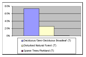
Forest cover Vegetation
Closed Forests
Broadleaved
Low- and medium-altitude evergreen rainforests on firm ground (Lebrun and Gilbert’s “equatorial rainforests”) account for about a third of the country’s closed forests on firm ground (35 to 40 million ha). In particular, they form a large ring around the central basin (which holds a high proportion of edaphic forests in swampy and flood-prone low-lying zones). They constitute the climax core from which a part of the semi-deciduous forests are derived, and are the far extremity of the extensive belt of Guinean equatorial rainforest that stretches east from Liberia. Typical tree species include Caesalpiniaceae such as Brachystegia laurentii, Gilbertiodendron dewevrei, G. ogoouense and Julbernadia seretii, Ebenaceae (Diospyros spp.), Olacaceae (Diogoa zenkeri and Heisteria parvifolia), Annonaceae (Isolona thonneri and Polyalthia suaveolens) and Myristicaceae such as Staudtia stipitata (trade niové). The first two species, like other Caesalpiniaceae in closed African forests (for example Monopetalanthus durandii stands in Gabon), are found in very large pure or nearly pure stands (Germain and Evrard, 1956). Gilbertiodendron dewevrei stands are also found in the Republic of the Congo and near the borders of Cameroon and the Central African Republic.
Low- and medium-altitude semi-deciduous moist closed forests on firm ground (Lebrun and Gilbert’s “semi-deciduous mesophile forests”) can be divided into three groups:
- “Subequatorial and Guinean semi-deciduous forests” are found in or on the edges of the equatorial evergreen forest and constitute the “syngenetic stages preceding climax” (“degraded semi-deciduous moist closed forests” in Devred’s classification). Typical species include Leguminosae such as Pericopsis elata (afrormosia, assamela or trade kokrodua), Copaifera soyauxii, Dialium spp., Gossweilerodendron balsamiferum (trade tola,), Oxystima oxyphyllum (trade tchitola) and Scorodophloeus zenkeri; Celtis spp. and Meliaceae such as Entandrophragma angolense (trade tiama), Guarea cedrata and G. thompsonii (trade bossé).
- “Subequatorial and periguinean semi-deciduous forests” are climax or edaphic forests in the peripheral areas of the central basin, located in Guinean savannah areas. Typical species are Albizia zygia, Bombax flammeum, Celtis kraussiana, Cordia chrysocarpa, Lovoa trichiliodes (trade dibetou), Milletia spp. (trade wenge), Parkia spp. and Pygeum africanum. Devred distinguishes, in particular, “subequatorial and Guinean semi-deciduous moist closed Cynometra alexandri forests” covering over half a million hectares on the eastern borders of Haut-Zaïre and Kivu provinces.
- “Zambezian semi-tropical semi-deciduous forests” constitute areas of closed forest in the midst of open forests and savannah woodlands in the south of the country. Known as muhulu, they contain a very large number of deciduous arborescent species which, together with their relatively low height (15 to 25 m), give them the appearance of dry closed forests. Typical species are Baphia bangweolensis, Brachystegia spiciformis var. schmitzii, Entandrophragma delevoyi and Manilkara spp.
Submontane and montane closed forests probably total no more than half a million hectares today and are confined to the eastern border of Kivu province. The following can be distinguished:
- “Montane rainforests” (the Ituri ridge, the slopes of Ruwenzori, the Virunga volcanoes, the Kivu ridge, and ridges bordering Lakes Kivu and Tanganyika) typically contain conifers (Podocarpus milanjianus, P. usambarensis and Juniperus procera) and broadleaved species such as Alangium chinense, Ekebergia ruppeliana, Ficalhoa laurifolia and Ocotea usumbarensis.
- “Montane sclerophyllous forests” are found between 1 500 and 3 200 m, occurring either as low forests (10 to 12 m) or as varyingly open scrub (which must therefore be classified as scrub formations). Typical species are Agauria salicifolia, Erica arborea, Ilex mitis, Myrica salicifolia, Pittosporum spp. and Rapanea spp.
- Submontane sclerophyllous forests of Grewia spp., Carissa edulis, Euphorbia calycina and E. dawei. These have practically disappeared from Burundi and Rwanda (except for the eastern part of the latter) and often occur as scrub formations.
“Edaphic forests linked to hydromorphic soil” are extensive in the Democratic Republic of the Congo, covering about 20 million ha, primarily in the central basin. Lebrun and Gilbert distinguish the following categories:
- “Riparian colonizing forests”, low forests or shrubs with a substratum permanently or nearly permanently bathed by water without ever being properly drained. In particular, they include forest fringes of Uapaca heudelotii, which mark the transition between pioneer shrub communities and swamp or periodically flooded forests;
- “Riparian or insular forests”, with a substratum subject to alternating heavy flooding and exposure with a short drainage period, containing such species as Cleistopholis patens, Ficus mucuso, Lannea welwitschii, Oxystigma buccholzii, Pseudospondias microcarpa and Spondianthus preussi;
- “Periodically flooded forests” with a relatively long dried-out period, of Guibourtia demeusi (trade bubinga), sometimes in pure stands or accompanied by other Caesalpiniaceae species such as Didelotia unifoliolata and Monopetalanthus pteriodophyllous and other families such as Oubanguia, Pachystela, Parinari and Scytopetalum;
- “Swamp forests” with no marked period of drying out and drainage, with typical species being Alstonia congensis, Berlinia heudelotiana, Entandrophragma palustre, Mitragyna ciliata, M. stipulosa and Uapaca guineensis;
- “Alluvial valley forests” on alluvial banks subject to periodic flooding, with Erythrina excelsa, Khaya nyasica, Pterygota mildbraedii and Sterculia ambacensis;
- Mangrove forests in the Congo delta and lagoons along the Atlantic coast with the most common species being Avicennia nitida, Conocarpus erectus and Rhizophora racemosa.
The succession of types of secondary forest that follow clearing for shifting cultivation is well described in Lebrun and Gilbert (1954), who make the following distinctions:
Forest Industry
Bamboo Palms
In the montane forests of Kivu between 2 350 and 2 550 m, as in Rwanda and Burundi, the “broadleaved-conifer forest” – to use Pierlot’s term (1966) – is often made up of an open coppice-with-standards system of Podocarpus usambarensis over a coppice of Arundinaria alpina. However, the upper storey is often very sparse or even absent, so that almost pure bamboo forests are found.
Oxytenanthera abyssinica bamboo forests are indicated on the 1:5 000 000 vegetation map of Shaba (the Kamina and Lubindi region, south of Kolwezi and north of Pweto, on the border with Zambia) and in the north-east of the country in the Mahagi and Aru region on the border with Uganda.
Open forests
Broadleaved
Open forest and savannah woodland corresponds to Lebrun and Gilbert’s “tropophile forests”, especially forms modified or degraded by clearing and fires. These two authors distinguish:
- “Zambezian tropophile forests”, which are subdivided as follows:
– Berlinia giorgii and Marquesia macroura stands, which act as a transition between semi-deciduous forests and proper tropophile forests, particularly in Bas-Zaïre and Bandundu provinces (“Guinean savannah tinged with Sudano-Zambezian elements to the west of Lake Leopold II”, in Devred’s classification). Typical species in this sector are Brachystegia mimosaefolia, Daniellia alsteeniana, Guibourtia coleosperma, Uapaca nitida and U. sansibarica;
– Balanites quarrei, Boscia caloneura and Fagara homblei stands on the cool soils of Shaba province;
– Brachystegia macrophylla and Monotes spp. stands;
- “Sudanian tropophile forests”, which are not common except on the borders of the Central African Republic and the Sudan (“Sudanian tropophile open forests” in Devred’s classification). Typical species include Butyrospermum parkii, Daniellia oliveri, Detarium senegalense, Erythroxylon manii, Isoberlinia spp. (including I. doka), Lophira lanceolata, Monotes kerstingii, Parinari kerstingii, Parkia biglobosa and Uapaca somon.
Devred’s vegetation map gives a more detailed classification of mixed forest and grass formations which includes the following categories as well as the two given above:
- “Guinean savannah tinged with Sudano-Zambezian elements”;
- “Degraded dry closed forests, replaced by tropophile open forests and islands of Zambezian savannah”;
- “Degraded tropophile open forests”;
- “Zambezian steppe savannah on the Bateke plateaux and in the southern Kwango region”;
- “Zambezian steppe savannah on the high Katangan plateaux”;
- “Savannah woodland on alluvial soil with Acacia sieberiana var. woodii and A. polyacantha var. campylacantha“;
- “Sudanian tropophile open forests”
Forest Map
Other wooded land
Shrubs
Devred distinguishes various categories of shrub savannah on the 1:5 000 000 vegetation map:
- “Transitional Guinean shrub savannah, tinged with Sudano-Zambezian elements” in the southern Kwango region in Bas-Zaïre and Bandundu provinces near the border with Angola;
- “Zambezian shrub savannah” in Shaba between the northern Guinean savannah zone to the north and the Zambezian tropophile open forest to the south;
- “Guinean and Sudano-Zambezian shrub savannah bordering valleys” in the region between the Kwango and Kwilu Rivers in Bandundu province;
- “Eastern shrub savannah tinged with Sudanian elements” on the edge of Lake Albert on the border with Uganda;
- “Transitional Guinean-eastern shrub savannah tinged with Sudanian elements” on the north-eastern borders with the Sudan and Uganda;
- “Sudanian shrub savannah” in the midst of “Sudanian tropophile open forest” north of the previous type.
As already mentioned, some “montane and submontane sclerophyllous forest” (in Lebrun and Gilbert’s classification) occurs as scrub. The same is true of some Sudano-Zambezian-type colonizing riparian forests “forming curtains or narrow galleries along water courses, colonizing marshes that are in the process of being filled in, or replacing reeds or papyrus” with Myrica spp. and Syzygium cordatum, and also of some Euphorbiaceae-based Guinean-type riparian forests with Alchornea cordifolia, Antidesma leptobotyrum and Phyllantus floribundus.
“Coastal sclerophyllous forest” (in Lebrun and Gilbert’s classification) “represents the culmination of plant colonization of coastal sands and appears to have achieved a balance with the coastal climate”. It occurs “mostly as groves or small spinneys” and occupies a negligible area in terms of all the scrub formations in the country.
References
Devred, R. (1960). La cartographie de la végétation au Congo Belge. Extrait du Vol. LI, No. 2 du Bulletin Agricole du Congo Belge et du Rwanda-Urundi. Brussels.
Germain, R. and Evrard, C. (1956). Etude écologique et phytosociologique de la forêt a Brachystegia laurentii. Publications de l’INEAC, Serie scientifique No. 67, Brussels.
Lebrun, J. and Gilbert, G. (1954). Une classification écologique des forêts du Congo. Publications de l’INEAC, Série scientifique No. 63, Brussels.
Pierlot, R. (1966). Structure et composition des forêts d’Afrique Centrale, spécialement celles du Kivu. Académie royale des Sciences d’Outre-mer. Brussels.
- Lowland fallow and regenerated forest “corresponding to the initial shrub or arborescent stages of reconstitution or recolonization in the region of lowland closed forests” and comprising “preforest wasteland and fallow” with Caloncoba welwitschoo, Harungana madagascariensis, Trema orientalis, etc., and forest regeneration, particularly Musanga cecropioides stands;
- Final arborescent stages of reconstitution, typically sheltering or associated with species from the original forest (“old secondary forests”), in particular with Pycnanthus angolensis (trade ilomba), and Fagara spp. in the evergreen forest zone, and Terminalia superba (trade limba